National Register of Historic Places listings in Suffolk County, Massachusetts
This is a list of the National Register of Historic Places listings in Suffolk County, Massachusetts.

This is intended to be a complete list of the properties and districts on the National Register of Historic Places in Suffolk County, Massachusetts, United States. Latitude and longitude coordinates are provided for many National Register properties and districts; these locations may be seen together in a map.[1]
There are 335 properties and districts listed on the National Register in the county, including 58 National Historic Landmarks. The city of Boston is the location of more than 300 of these properties and districts, including 57 National Historic Landmarks; they are listed separately. Properties and districts located in the county's other three municipalities are listed here.
- This National Park Service list is complete through NPS recent listings posted January 29, 2021.[2]
Current listings
For reasons of length, the Boston list has been split into northern and southern listings, divided by the Massachusetts Turnpike. Northern Boston has 147 of these listings, including 39 districts, 48 landmarks, and three National Historic Landmark Districts. Southern Boston, including locations in Boston Harbor, has 163 listings, including 46 districts, 12 landmarks, and one National Historic Landmark District. Two historic districts overlap into both northern and southern Boston: milestones that make up the 1767 Milestones are found in both areas, and the Olmsted Park System extends through much of the city.
Boston
| Area | Image | First Date listed | Last Date listed | Count |
|---|---|---|---|---|
| Northern | 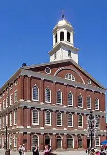 |
October 15, 1966 | August 1, 2017 | 147 |
| Southern | 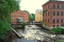 |
October 15, 1966 | November 18, 2020 | 168 |
Other municipalities
| [3] | Name on the Register[4] | Image | Date listed[5] | Location | City or town | Description |
|---|---|---|---|---|---|---|
| 1 | Bellingham Square Historic District | 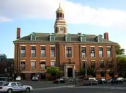 Bellingham Square Historic District |
January 3, 1985 (#85000030) |
Roughly bounded by Broadway, Shawmut, Chestnut, and Shurtleff Sts. 42°23′37″N 71°02′02″W |
Chelsea | |
| 2 | Bellingham-Cary House |  Bellingham-Cary House |
September 6, 1974 (#74000908) |
34 Parker St. 42°23′54″N 71°01′41″W |
Chelsea | |
| 3 | Chelsea Garden Cemetery | 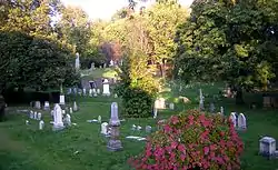 Chelsea Garden Cemetery |
February 9, 2001 (#01000089) |
70 Central Ave. 42°23′25″N 71°02′00″W |
Chelsea | |
| 4 | Church of Christ | 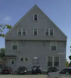 Church of Christ |
November 13, 1984 (#84000430) |
265 Beach St. 42°24′33″N 71°00′26″W |
Revere | |
| 5 | Congregation Agudath Shalom | 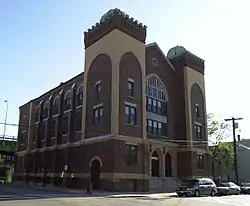 Congregation Agudath Shalom |
April 16, 1993 (#93000283) |
145 Walnut St. 42°23′34″N 71°02′17″W |
Chelsea | |
| 6 | Downtown Chelsea Residential Historic District | 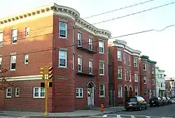 Downtown Chelsea Residential Historic District |
June 22, 1988 (#88000718) |
Roughly bounded by Shurtleff, Marginal, and Division Sts. and Bellingham Sq. 42°23′21″N 71°02′15″W |
Chelsea | |
| 7 | Fort Banks Mortar Battery |  Fort Banks Mortar Battery |
March 12, 2007 (#07000144) |
Kennedy Dr. 42°23′04″N 70°58′49″W |
Winthrop | |
| 8 | Highland School | 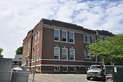 Highland School |
March 18, 2014 (#14000063) |
36 Grovers Ave. 42°23′06″N 70°58′23″W |
Winthrop | |
| 9 | Immaculate Conception Rectory | 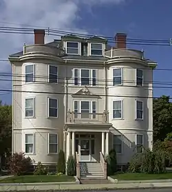 Immaculate Conception Rectory |
February 11, 2002 (#01001559) |
108 Beach St. 42°24′25″N 71°00′42″W |
Revere | |
| 10 | C. Henry Kimball House | 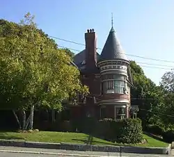 C. Henry Kimball House |
April 15, 1982 (#82004464) |
295 Washington Ave. 42°23′58″N 71°02′06″W |
Chelsea | |
| 11 | Luna (tugboat) | 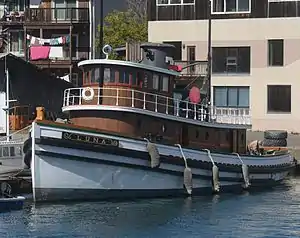 Luna (tugboat) |
October 6, 1983 (#83004099) |
Chelsea, Massachusetts 42°23′11″N 71°02′30″W |
Chelsea | The first diesel-electric ship docking tugboat and now the last full size wood tugboat. |
| 12 | Naval Hospital Boston Historic District | 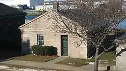 Naval Hospital Boston Historic District |
August 14, 1973 (#73000851) |
1 Broadway 42°23′13″N 71°02′44″W |
Chelsea | |
| 13 | Edward B. Newton School | 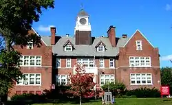 Edward B. Newton School |
August 18, 1997 (#97000878) |
131 Pauline St. 42°22′33″N 70°59′13″W |
Winthrop | |
| 14 | Revere Beach Parkway-Metropolitan Park System of Greater Boston |  Revere Beach Parkway-Metropolitan Park System of Greater Boston |
December 6, 2007 (#07001241) |
Revere Beach Pkwy 42°24′16″N 71°01′49″W |
Chelsea | Extends into Everett and Medford in Middlesex County |
| 15 | Revere Beach Reservation |  Revere Beach Reservation |
May 27, 2003 (#03000642) |
Revere Beach Boulevard, Eliot Circle to Northern Circle 42°25′15″N 70°59′08″W |
Revere | |
| 16 | Revere Beach Reservation Historic District | 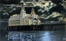 Revere Beach Reservation Historic District |
July 15, 1998 (#98000871) |
Roughly bounded by Eliot Circle, Revere Beach Boulevard, Northern Circle, and the Atlantic Ocean 42°25′15″N 70°59′08″W |
Revere | |
| 17 | Revere City Hall and Police Station | 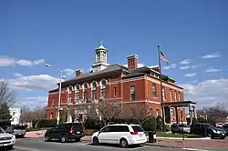 Revere City Hall and Police Station |
March 7, 2012 (#12000070) |
281 Broadway & 23 Pleasant St. 42°24′28″N 71°00′47″W |
Revere | |
| 18 | Mary T. Ronan School |  Mary T. Ronan School |
December 10, 1982 (#82000485) |
154 Bradstreet Ave. 42°23′46″N 70°59′14″W |
Revere | |
| 19 | Rumney Marsh Burying Ground |  Rumney Marsh Burying Ground |
February 11, 2004 (#04000025) |
Butler St. at Elm and Bixby Sts. 42°24′27″N 71°00′23″W |
Revere | |
| 20 | Winthrop Center/Metcalf Square Historic District |  Winthrop Center/Metcalf Square Historic District |
March 23, 2010 (#10000098) |
Roughly bounded by Lincoln, Winthrop Sts., Winthrop Cemetery, Buchanan, Fremont, Pauline, Hermon and Belcher Sts. 42°22′37″N 70°59′04″W |
Winthrop | |
| 21 | Deane Winthrop House |  Deane Winthrop House |
March 9, 1990 (#90000162) |
34 Shirley St. 42°22′57″N 70°58′41″W |
Winthrop | |
| 22 | Winthrop Parkway, Metropolitan Parkway System of Greater Boston | Winthrop Parkway, Metropolitan Parkway System of Greater Boston |
January 21, 2004 (#03001471) |
Winthrop Parkway 42°23′29″N 70°58′55″W |
Revere | |
| 23 | Winthrop Shore Dr., Metropolitan Park System of Greater Boston | Winthrop Shore Dr., Metropolitan Park System of Greater Boston |
January 21, 2004 (#03001469) |
Winthrop Shore Dr. 42°22′11″N 70°58′05″W |
Winthrop |
| Wikimedia Commons has media related to National Register of Historic Places in Suffolk County, Massachusetts. |
References
- The latitude and longitude information provided in this table was derived originally from the National Register Information System, which has been found to be fairly accurate for about 99% of listings. Some locations in this table may have been corrected to current GPS standards.
- "National Register of Historic Places: Weekly List Actions". National Park Service, United States Department of the Interior. Retrieved on January 29, 2021.
- Numbers represent an alphabetical ordering by significant words. Various colorings, defined here, differentiate National Historic Landmarks and historic districts from other NRHP buildings, structures, sites or objects.
- "National Register Information System". National Register of Historic Places. National Park Service. March 13, 2009.
- The eight-digit number below each date is the number assigned to each location in the National Register Information System database, which can be viewed by clicking the number.
| Topics |  | ||||||||||||||||
|---|---|---|---|---|---|---|---|---|---|---|---|---|---|---|---|---|---|
| Lists by county | |||||||||||||||||
| Lists by city |
| ||||||||||||||||
| Other lists | |||||||||||||||||
| |||||||||||||||||