National Register of Historic Places listings in Southbridge, Massachusetts
The following properties in Southbridge, Massachusetts are listed on the National Register of Historic Places.
- This National Park Service list is complete through NPS recent listings posted January 29, 2021.[1]
Southbridge
| [2] | Name on the Register | Image | Date listed[3] | Location | Description |
|---|---|---|---|---|---|
| 1 | Academie Brochu |  Academie Brochu |
June 22, 1989 (#89000568) |
29 Pine St. 42°04′46″N 72°02′17″W |
|
| 2 | William E. Alden House |  William E. Alden House |
June 22, 1989 (#89000562) |
428 Hamilton St. 42°04′55″N 72°02′28″W |
|
| 3 | Alden-Delahanty Block |  Alden-Delahanty Block |
June 22, 1989 (#89000572) |
858 Main St. 42°04′54″N 72°02′46″W |
|
| 4 | Ammidown-Harding Farmhouse |  Ammidown-Harding Farmhouse |
June 22, 1989 (#89000552) |
83 Lebanon Hill Rd. 42°03′35″N 72°02′05″W |
|
| 5 | Ashland Mill Tenement |  Ashland Mill Tenement |
June 22, 1989 (#89000545) |
141–145 Ashland Ave. 42°03′55″N 72°00′37″W |
|
| 6 | Bacon-Morse Historic District |  Bacon-Morse Historic District |
June 22, 1989 (#89000602) |
N. Woodstock Rd. at Tipton Rock Rd. 42°02′09″N 72°00′48″W |
|
| 7 | Beechwood |  Beechwood |
June 22, 1989 (#89000527) |
495 Main St. 42°04′38″N 72°02′18″W |
|
| 8 | Alexis Boyer House |  Alexis Boyer House |
June 22, 1989 (#89000560) |
306 Hamilton 42°04′53″N 72°02′16″W |
|
| 9 | Building at 25–27 River Street |  Building at 25–27 River Street |
June 22, 1989 (#89000574) |
25–27 River St. 42°04′56″N 72°02′21″W |
|
| 10 | Building at 29–31 River Street |  Building at 29–31 River Street |
June 22, 1989 (#89000575) |
29–31 River St. 42°04′56″N 72°02′21″W |
|
| 11 | Building at 38–42 Worcester Street |  Building at 38–42 Worcester Street |
June 22, 1989 (#89000589) |
38–42 Worcester St. 42°04′46″N 72°01′47″W |
|
| 12 | Building at 52 Main Street |  Building at 52 Main Street |
June 22, 1989 (#89000583) |
52 Main St. 42°04′24″N 72°01′39″W |
|
| 13 | Central Mills Historic District |  Central Mills Historic District |
June 22, 1989 (#89000595) |
Roughly bounded by the Quinebaug River, North St., and Central St. 42°04′37″N 72°01′53″W |
|
| 14 | Centre Village Historic District |  Centre Village Historic District |
September 7, 1979 (#79000379) |
Along Main St. 42°04′32″N 72°02′04″W |
|
| 15 | Chamberlain-Bordeau House |  Chamberlain-Bordeau House |
June 22, 1989 (#89000569) |
718 Main St. 42°04′49″N 72°02′35″W |
|
| 16 | Chapin Block | 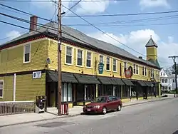 Chapin Block |
June 22, 1989 (#89000558) |
208–222 Hamilton 42°04′48″N 72°02′08″W |
|
| 17 | Alpha M. Cheney House | 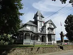 Alpha M. Cheney House |
June 22, 1989 (#89000526) |
61 Chestnut St. 42°04′16″N 72°01′39″W |
|
| 18 | J.M. Cheney Rental House |  J.M. Cheney Rental House |
June 22, 1989 (#89000564) |
32 Edwards St. 42°04′44″N 72°02′10″W |
|
| 19 | Clarke-Glover Farmhouse |  Clarke-Glover Farmhouse |
June 22, 1989 (#89000536) |
201 South St. 42°04′34″N 72°02′45″W |
|
| 20 | Cliff Cottage | 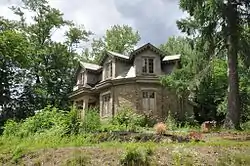 Cliff Cottage |
June 22, 1989 (#89000570) |
787 Mill St. 42°05′01″N 72°02′29″W |
|
| 21 | E. Merritt Cole House |  E. Merritt Cole House |
June 22, 1989 (#89000576) |
386 Main St. 42°04′36″N 72°02′08″W |
|
| 22 | Comins-Wall House |  Comins-Wall House |
June 22, 1989 (#89000555) |
42 Hamilton St. 42°04′35″N 72°02′04″W |
|
| 23 | Congregational Church |  Congregational Church |
June 22, 1989 (#89000591) |
61 Elm St. 42°04′23″N 72°02′06″W |
|
| 24 | E. B. Cummings House |  E. B. Cummings House |
June 22, 1989 (#89000566) |
52 Marcy St. 42°04′43″N 72°02′15″W |
|
| 25 | Dani and Soldani Cabinet Makers and Wood Workers Factory |  Dani and Soldani Cabinet Makers and Wood Workers Factory |
June 22, 1989 (#89000529) |
484 Worcester St. 42°05′26″N 72°01′22″W |
|
| 26 | Dennison School House |  Dennison School House |
June 22, 1989 (#89000551) |
Dennison Ln. 42°03′38″N 72°03′42″W |
|
| 27 | Sylvester Dresser House |  Sylvester Dresser House |
June 22, 1989 (#89000523) |
29 Summer St. 42°04′18″N 72°02′05″W |
|
| 28 | Dunbar-Vinton House | 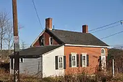 Dunbar-Vinton House |
June 22, 1989 (#89000573) |
Hook and Hamilton Sts. 42°04′38″N 72°02′03″W |
|
| 29 | Henry E. Durfee Farmhouse |  Henry E. Durfee Farmhouse |
June 22, 1989 (#89000547) |
281 Eastford Rd. 42°03′49″N 72°02′33″W |
|
| 30 | Elm Street Fire House | 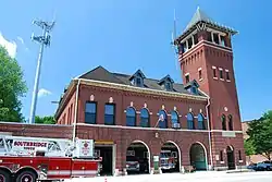 Elm Street Fire House |
June 22, 1989 (#89000530) |
24 Elm St. 42°04′27″N 72°02′06″W |
|
| 31 | Evangelical Free Church |  Evangelical Free Church |
June 22, 1989 (#89000561) |
Hamilton St. 42°04′55″N 72°02′29″W |
|
| 32 | James Gleason Cottage |  James Gleason Cottage |
June 22, 1989 (#89000533) |
31 Sayles St. 42°04′45″N 72°02′37″W |
|
| 33 | Globe Village Fire House |  Globe Village Fire House |
June 22, 1989 (#89000540) |
West St. at Main St. 42°04′47″N 72°02′45″W |
|
| 34 | Glover Street Historic District |  Glover Street Historic District |
June 22, 1989 (#89000601) |
Glover St. between High and Poplar Sts. 42°04′28″N 72°02′49″W |
|
| 35 | Hamilton Mill Brick House |  Hamilton Mill Brick House |
June 22, 1989 (#89000542) |
16 High St. 42°04′48″N 72°02′43″W |
|
| 36 | Hamilton Mill-West Street Factory Housing |  Hamilton Mill-West Street Factory Housing |
June 22, 1989 (#89000541) |
45 West St. 42°04′46″N 72°02′47″W |
|
| 37 | Hamilton Millwright-Agent's House |  Hamilton Millwright-Agent's House |
June 22, 1989 (#89000543) |
757–761 Main St. 42°04′48″N 72°02′40″W |
|
| 38 | Hamilton Woolen Company Historic District | 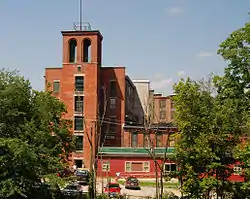 Hamilton Woolen Company Historic District |
June 22, 1989 (#89000594) |
Roughly bounded by McKinstry Brook, the Quinebaug River, and Mill St. 42°04′56″N 72°02′37″W |
|
| 39 | Theodore Harrington House |  Theodore Harrington House |
June 22, 1989 (#89000557) |
77 Hamilton St. 42°04′37″N 72°02′07″W |
|
| 40 | George H. Hartwell House |  George H. Hartwell House |
June 22, 1989 (#89000556) |
105 Hamilton St. 42°04′39″N 72°02′08″W |
|
| 41 | Samuel C. Hartwell House |  Samuel C. Hartwell House |
June 22, 1989 (#89000592) |
79 Elm St. 42°04′22″N 72°02′07″W |
|
| 42 | High-School Streets Historic District |  High-School Streets Historic District |
June 22, 1989 (#89000600) |
High St. at School St. 42°04′40″N 72°02′45″W |
|
| 43 | William Hodgson Two-Family House |  William Hodgson Two-Family House |
June 22, 1989 (#89000578) |
103–105 Sayles St. 42°04′38″N 72°02′38″W |
Probably demolished. |
| 44 | House at 3 Dean Street | 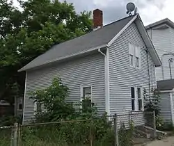 House at 3 Dean Street |
June 22, 1989 (#89000587) |
3 Dean St. 42°04′32″N 72°01′42″W |
|
| 45 | House at 18 Walnut Street |  House at 18 Walnut Street |
June 22, 1989 (#89000580) |
18 Walnut St. 42°04′25″N 72°01′46″W |
|
| 46 | House at 34 Benefit Street |  House at 34 Benefit Street |
June 22, 1989 (#89000585) |
34 Benefit St. 42°04′31″N 72°01′46″W |
|
| 47 | House at 59–63 Crystal Street |  House at 59–63 Crystal Street |
June 22, 1989 (#89000584) |
59–63 Crystal St. 42°04′29″N 72°01′40″W |
|
| 48 | House at 64 Main Street |  House at 64 Main Street |
June 22, 1989 (#89000582) |
64 Main St. 42°04′23″N 72°01′41″W |
|
| 49 | House at 70–72 Main Street |  House at 70–72 Main Street |
June 22, 1989 (#89000581) |
70–72 Main St. 42°04′23″N 72°01′43″W |
|
| 50 | House at 91 Coombs Street |  House at 91 Coombs Street |
June 22, 1989 (#89000525) |
91 Coombs St. 42°04′18″N 72°01′48″W |
Probably demolished. |
| 51 | Judson-Litchfield House |  Judson-Litchfield House |
June 22, 1989 (#89000539) |
313 South St. 42°04′34″N 72°03′01″W |
|
| 52 | A. Kinney House |  A. Kinney House |
June 22, 1989 (#89000565) |
42 Edwards St. 42°04′44″N 72°02′12″W |
|
| 53 | LaCroix-Mosher House |  LaCroix-Mosher House |
June 22, 1989 (#89000524) |
56 Everett St. 42°04′21″N 72°02′02″W |
|
| 54 | Napoleon LaRochelle Two-Family House |  Napoleon LaRochelle Two-Family House |
June 22, 1989 (#89000567) |
30 Pine St. 42°04′51″N 72°03′00″W |
|
| 55 | Maple Street Historic District |  Maple Street Historic District |
June 22, 1989 (#89000597) |
Maple St. 42°04′26″N 72°01′43″W |
|
| 56 | Mrs. R. Marcy House |  Mrs. R. Marcy House |
June 22, 1989 (#89000535) |
64 South St. 42°04′38″N 72°02′28″W |
|
| 57 | William McKinstry Farmhouse |  William McKinstry Farmhouse |
June 22, 1989 (#89000571) |
361 Pleasant St. 42°05′41″N 72°02′35″W |
|
| 58 | William McKinstry Jr. House |  William McKinstry Jr. House |
June 22, 1989 (#89000528) |
915 W. Main St. 42°04′55″N 72°02′52″W |
|
| 59 | H. Morse House |  H. Morse House |
June 22, 1989 (#89000538) |
230 South St. 42°04′34″N 72°02′50″W |
|
| 60 | New York, New Haven & Hartford Passenger Depot | 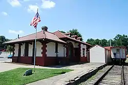 New York, New Haven & Hartford Passenger Depot |
June 22, 1989 (#89000554) |
Depot St. 42°04′37″N 72°02′00″W |
|
| 61 | Notre Dame Catholic Church | 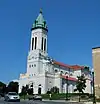 Notre Dame Catholic Church |
June 22, 1989 (#89000563) |
Main St. at Marcy St. 42°04′40″N 72°02′13″W |
|
| 62 | J.J. Oakes House |  J.J. Oakes House |
June 22, 1989 (#89000534) |
14 South St. 42°04′39″N 72°02′20″W |
|
| 63 | E.M. Phillips House |  E.M. Phillips House |
June 22, 1989 (#89000532) |
35 Dresser St. 42°04′25″N 72°02′12″W |
|
| 64 | Simon Plimpton Farmhouse |  Simon Plimpton Farmhouse |
June 22, 1989 (#89000550) |
561 South St. 42°04′29″N 72°03′18″W |
|
| 65 | Stephen Richard House |  Stephen Richard House |
June 22, 1989 (#89000522) |
239–241 Elm St. 42°04′06″N 72°02′11″W |
|
| 66 | Sacred Heart Church Historic District | 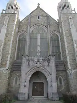 Sacred Heart Church Historic District |
June 22, 1989 (#89000598) |
Charlton St. 42°04′40″N 72°01′44″W |
|
| 67 | Smith-Lyon Farmhouse |  Smith-Lyon Farmhouse |
June 22, 1989 (#89000546) |
400 N. Woodstock Rd. 42°03′18″N 72°01′00″W |
|
| 68 | Southbridge Town Hall | 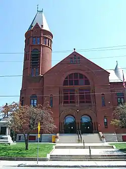 Southbridge Town Hall |
November 20, 1987 (#87001378) |
41 Elm St. 42°04′23″N 72°02′05″W |
|
| 69 | St. George's Greek Orthodox Church |  St. George's Greek Orthodox Church |
June 22, 1989 (#89000579) |
55 North St. 42°04′36″N 72°01′48″W |
|
| 70 | St. Peter's Roman Catholic Church-St. Mary's School |  St. Peter's Roman Catholic Church-St. Mary's School |
June 22, 1989 (#89000559) |
263 Hamilton St. 42°04′51″N 72°02′16″W |
Destroyed by fire in 1999.[4] |
| 71 | Lorenzo R. Stone House |  Lorenzo R. Stone House |
June 22, 1989 (#89000537) |
218 South St. 42°04′35″N 72°02′48″W |
|
| 72 | George Sumner House |  George Sumner House |
June 22, 1989 (#89000577) |
32 Paige Hill Rd. 42°04′44″N 72°01′54″W |
|
| 73 | Eugene Tapin House |  Eugene Tapin House |
June 22, 1989 (#89000549) |
215 Lebanon Hill Rd. 42°03′21″N 72°02′15″W |
|
| 74 | Tiffany-Leonard House |  Tiffany-Leonard House |
June 22, 1989 (#89000590) |
25 Elm St. 42°04′26″N 72°02′04″W |
|
| 75 | Twinehurst American Optical Company Neighborhood | 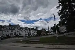 Twinehurst American Optical Company Neighborhood |
June 22, 1989 (#89000593) |
Twinehurst Place 42°04′42″N 72°01′57″W |
Residential district on Twinehurst Place; does not include company factory buildings. |
| 76 | Upper Chapin Street Historic District |  Upper Chapin Street Historic District |
June 22, 1989 (#89000599) |
Chapin St. at Forest Ave. 42°04′20″N 72°02′15″W |
|
| 77 | Vinton-Boardman Farmhouse |  Vinton-Boardman Farmhouse |
June 22, 1989 (#89000586) |
93 Torrey Rd. 42°05′07″N 72°00′33″W |
|
| 78 | Vinton-Torrey House |  Vinton-Torrey House |
June 22, 1989 (#89000588) |
5 Torrey Rd. 42°05′05″N 72°00′32″W |
|
| 79 | George B. and Ruth D. Wells House |  George B. and Ruth D. Wells House |
June 22, 1989 (#89000548) |
Durfee Rd. 42°03′43″N 72°03′01″W |
|
| 80 | H.C. Wells Double House |  H.C. Wells Double House |
June 22, 1989 (#89000531) |
28–30 Dresser St. 42°04′26″N 72°02′10″W |
|
| 81 | John M. Wells House |  John M. Wells House |
June 22, 1989 (#89000553) |
491 Eastford Rd. 42°03′32″N 72°02′55″W |
|
| 82 | Albert H. Wheeler House |  Albert H. Wheeler House |
June 22, 1989 (#89000544) |
219 South St. 42°04′34″N 72°02′47″W |
|
| 83 | Windsor Court Historic District |  Windsor Court Historic District |
June 22, 1989 (#89000596) |
Windsor Ct. at North St. 42°04′33″N 72°01′52″W |
References
| Wikimedia Commons has media related to National Register of Historic Places in Southbridge, Massachusetts. |
- "National Register of Historic Places: Weekly List Actions". National Park Service, United States Department of the Interior. Retrieved on January 29, 2021.
- Numbers represent an alphabetical ordering by significant words. Various colorings, defined here, differentiate National Historic Landmarks and historic districts from other NRHP buildings, structures, sites or objects.
- The eight-digit number below each date is the number assigned to each location in the National Register Information System database, which can be viewed by clicking the number.
- "Cultural Inventory Record for St. Peter's Church". Commonwealth of Massachusetts. Retrieved 2013-10-16.
| Topics |  | ||||||||||||||||
|---|---|---|---|---|---|---|---|---|---|---|---|---|---|---|---|---|---|
| Lists by county | |||||||||||||||||
| Lists by city |
| ||||||||||||||||
| Other lists | |||||||||||||||||
| |||||||||||||||||
This article is issued from Wikipedia. The text is licensed under Creative Commons - Attribution - Sharealike. Additional terms may apply for the media files.