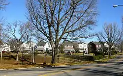
Battery Court Historic District
The Battery Court Historic District is a national historic district located at Richmond, Virginia. The district encompasses 549 contributing buildings and 1 contributing site (Battery Park) located north of downtown Richmond and west of Barton Heights and Brookland Park. The primarily residential area developed starting in the early-20th century as one of the city's early “streetcar suburbs.” The buildings are in a variety of popular late-19th and early-20th century architectural styles including frame bungalows, American Foursquare, Colonial Revival, Tudor Revival, and Mission Revival. Notable non-residential buildings include the Overbrook Presbyterian Church (now All Souls Presbyterian) and Battery Park Christian Church (now Mount Hermon Baptist).[3]
Battery Court Historic District | |
 Battery Court Historic District, January 2012 | |
  | |
| Location | Roughly Dupont C., Edgewood, Fendall, Greenwood, Griffin, Montrose, Moss Side, Noble, North, Edgehill, Graham., Richmond, Virginia |
|---|---|
| Coordinates | 37°34′02″N 77°26′23″W |
| Area | 181 acres (73 ha) |
| Architectural style | Late 19th And 20th Century Revivals, Late 19th And Early 20th Century American Movements |
| MPS | Streetcar Suburbs in Northside Richmond MPS |
| NRHP reference No. | 02000594[1] |
| VLR No. | 127-5897 |
| Significant dates | |
| Added to NRHP | October 9, 2003 |
| Designated VLR | September 30, 2001[2] |
It was added to the National Register of Historic Places in 2003.[1]
References
- "National Register Information System". National Register of Historic Places. National Park Service. July 9, 2010.
- "Virginia Landmarks Register". Virginia Department of Historic Resources. Archived from the original on 2013-09-21. Retrieved 19 March 2013.
- Kimberly Merkel Chen; Mary Harding Sadler; Peter MacDearmon Witt & Jean McRae (June 2003). "National Register of Historic Places Inventory/Nomination: Battery Court Historic District" (PDF). Virginia Department of Historic Resources. Archived from the original (PDF) on 2012-09-27. Retrieved 2014-01-11. and Accompanying photo Archived 2012-09-27 at the Wayback Machine and Accompanying map Archived 2014-01-11 at the Wayback Machine

