National Register of Historic Places listings in Goochland County, Virginia
This is a list of the National Register of Historic Places listings in Goochland County, Virginia.
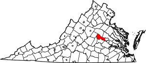
Location of Goochland County in Virginia
This is intended to be a complete list of the properties and districts on the National Register of Historic Places in Goochland County, Virginia, United States. The locations of National Register properties and districts for which the latitude and longitude coordinates are included below, may be seen in an online map.[1]
There are 25 properties and districts listed on the National Register in the county, including 1 National Historic Landmark.
- This National Park Service list is complete through NPS recent listings posted January 29, 2021.[2]
Current listings
| [3] | Name on the Register[4] | Image | Date listed[5] | Location | City or town | Description |
|---|---|---|---|---|---|---|
| 1 | Belvidere |  Belvidere |
August 15, 2016 (#16000529) |
4024 Pace Rd. 37°48′51″N 78°00′20″W |
Hadensville | |
| 2 | Ben Dover |  Ben Dover |
April 14, 2000 (#00000311) |
661 W. State Route 6 37°36′27″N 77°44′16″W |
Manakin-Sabot | |
| 3 | Bolling Hall |  Bolling Hall |
December 27, 1972 (#72001397) |
West of Goochland off Rock Castle Rd. 37°40′55″N 77°57′34″W |
Goochland | |
| 4 | Bolling Island | 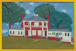 Bolling Island |
December 27, 1990 (#89001926) |
Stokes Station Rd. 37°39′21″N 78°02′23″W |
Goochland | |
| 5 | Brightly |  Brightly |
August 16, 2006 (#06000705) |
2844 W. U.S. Route 322 37°40′34″N 77°53′08″W |
Goochland | |
| 6 | Byrd Presbyterian Church | 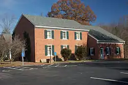 Byrd Presbyterian Church |
November 22, 2000 (#00001438) |
2229 Dogtown Rd. 37°42′51″N 77°56′23″W |
Goochland | |
| 7 | Cartersville Bridge |  Cartersville Bridge |
September 14, 1972 (#72001390) |
State Route 45 over the James River 37°40′17″N 78°05′11″W |
Cartersville | Extends into Cumberland County |
| 8 | Dover Slave Quarter Complex |  Dover Slave Quarter Complex |
September 15, 2002 (#02001005) |
854 Dover Rd. 37°37′46″N 77°46′17″W |
Manakin-Sabot | |
| 9 | Elk Hill | 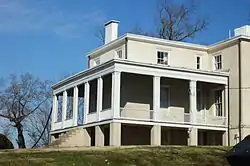 Elk Hill |
February 28, 1979 (#79003042) |
West of Goochland off State Route 6 37°43′01″N 78°05′05″W |
Goochland | |
| 10 | First Union School |  First Union School |
August 12, 2009 (#09000614) |
1522 Old Mill Rd. 37°39′07″N 77°47′37″W |
Crozier | |
| 11 | Goochland County Court Square | .jpg.webp) Goochland County Court Square |
September 15, 1970 (#70000797) |
State Route 6 37°40′57″N 77°53′03″W |
Goochland | |
| 12 | Howard's Neck Plantation | February 23, 1972 (#72001398) |
1 mile (1.6 km) northwest of Pemberton 37°40′51″N 78°05′39″W |
Pemberton | ||
| 13 | Jackson Blacksmith Shop |  Jackson Blacksmith Shop |
December 11, 1997 (#97001511) |
2558 Blacksmith Shop Rd. 37°44′32″N 77°54′19″W |
Goochland | |
| 14 | Lock-Keeper's House | 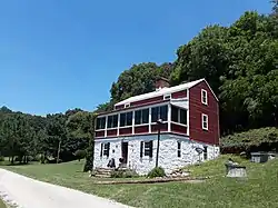 Lock-Keeper's House |
November 21, 1974 (#74002119) |
Off State Route 6 at the James River 37°41′29″N 77°54′32″W |
Cedar Point | |
| 15 | Mount Bernard Complex |  Mount Bernard Complex |
January 20, 2005 (#04001537) |
2371 W. State Route 6 37°39′25″N 77°51′30″W |
Maidens | |
| 16 | Oak Grove |  Oak Grove |
September 16, 2009 (#09000727) |
664 Manakin Rd. 37°36′43″N 77°42′15″W |
Manakin-Sabot | |
| 17 | Powell's Tavern |  Powell's Tavern |
April 2, 1973 (#73002020) |
River Rd. 37°34′57″N 77°39′37″W |
Manakin | |
| 18 | Rochambeau Farm |  Rochambeau Farm |
August 5, 1999 (#99000969) |
1080 Manakin Rd. 37°37′55″N 77°43′09″W |
Manakin-Sabot | |
| 19 | Rock Castle |  Rock Castle |
September 15, 1970 (#70000798) |
Rock Castle Rd. 37°37′45″N 77°58′49″W |
Rock Castle | |
| 20 | Second Union School |  Second Union School |
January 31, 2006 (#05001583) |
2787 Hadensville Fife Rd. 37°45′53″N 78°03′09″W |
Goochland | |
| 21 | Springdale |  Springdale |
December 4, 2002 (#02001490) |
2048 Cardwell Rd. 37°41′27″N 77°47′21″W |
Crozier | |
| 22 | Tanglewood-037-5010 |  Tanglewood-037-5010 |
July 11, 2002 (#02000775) |
2200-2210 W. State Route 6 37°39′08″N 77°50′45″W |
Maidens | |
| 23 | Tinsley Tavern |  Tinsley Tavern |
April 4, 2007 (#07000276) |
2791 Elk Island Rd. 37°45′44″N 78°06′01″W |
Columbia | |
| 24 | Tuckahoe | 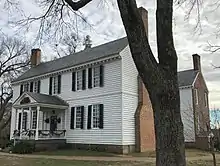 Tuckahoe |
November 22, 1968 (#68000049) |
Southeast of Manakin near the junction of River Rd. and Pagebrook Dr. 37°34′12″N 77°39′10″W |
Manakin | |
| 25 | Woodlawn | 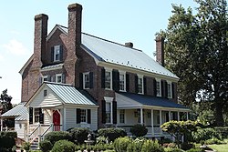 Woodlawn |
December 16, 1971 (#71000978) |
Southeast of Oilville at the junction of U.S. Route 250 and Threechopt Rd. 37°41′06″N 77°44′11″W |
Oilville |
See also
| Wikimedia Commons has media related to National Register of Historic Places in Goochland County, Virginia. |
References
- The latitude and longitude information provided in this table was derived originally from the National Register Information System, which has been found to be fairly accurate for about 99% of listings. Some locations in this table may have been corrected to current GPS standards.
- "National Register of Historic Places: Weekly List Actions". National Park Service, United States Department of the Interior. Retrieved on January 29, 2021.
- Numbers represent an alphabetical ordering by significant words. Various colorings, defined here, differentiate National Historic Landmarks and historic districts from other NRHP buildings, structures, sites or objects.
- "National Register Information System". National Register of Historic Places. National Park Service. April 24, 2008.
- The eight-digit number below each date is the number assigned to each location in the National Register Information System database, which can be viewed by clicking the number.

Municipalities and communities of Goochland County, Virginia, United States | ||
|---|---|---|
| CDP | Map of Virginia highlighting Goochland County | |
| Unincorporated communities | ||
| ||
This article is issued from Wikipedia. The text is licensed under Creative Commons - Attribution - Sharealike. Additional terms may apply for the media files.