National Register of Historic Places listings in Pittsylvania County, Virginia
This is a list of the National Register of Historic Places listings in Pittsylvania County, Virginia.

Location of Pittsylvania County in Virginia
This is intended to be a complete list of the properties and districts on the National Register of Historic Places in Pittsylvania County, Virginia, United States. The locations of National Register properties and districts for which the latitude and longitude coordinates are included below, may be seen in an online map.[1]
There are 21 properties and districts listed on the National Register in the county, including 1 National Historic Landmark. Another 2 properties were once listed but have been removed.
- This National Park Service list is complete through NPS recent listings posted January 29, 2021.[2]
Current listings
| [3] | Name on the Register[4] | Image | Date listed[5] | Location | City or town | Description |
|---|---|---|---|---|---|---|
| 1 | Berry Hill | 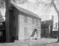 Berry Hill |
May 6, 1980 (#80004210) |
Southwest of Berry Hill 36°32′43″N 79°37′12″W |
Berry Hill | |
| 2 | Bill's Diner | 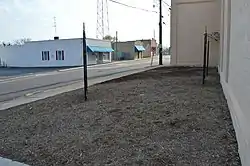 Bill's Diner |
December 16, 1996 (#96001450) |
1 Depot St. 36°49′30″N 79°23′54″W |
Chatham | |
| 3 | Burnett's Diner | 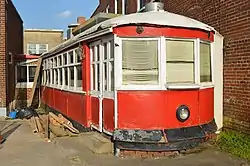 Burnett's Diner |
December 16, 1996 (#96001451) |
19 S. Main St. 36°49′32″N 79°23′53″W |
Chatham | |
| 4 | Chatham Historic District | _(2).jpg.webp) Chatham Historic District |
July 13, 2001 (#01000698) |
Main, Payne, Pruden, Reid, and Whittle Sts., Lanier Ave., Court Place, and Gilmer Dr. 36°49′33″N 79°23′54″W |
Chatham | |
| 5 | Chatham Southern Railway Depot | 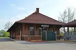 Chatham Southern Railway Depot |
August 24, 2015 (#15000550) |
340 Whitehead St. 36°49′15″N 79°24′09″W |
Chatham | |
| 6 | Clerk's Office | 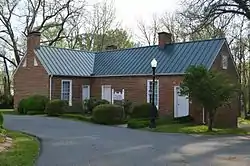 Clerk's Office |
July 8, 1982 (#82004580) |
Main St. 36°49′34″N 79°24′00″W |
Chatham | |
| 7 | Phillip Craft House | 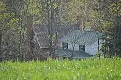 Phillip Craft House |
February 16, 2001 (#01000144) |
1381 Old Red Eye Rd. 36°54′13″N 79°27′35″W |
Chatham | Destroyed by fire on April 18, 2017[6] |
| 8 | Thomas Claiborne Creasy House | 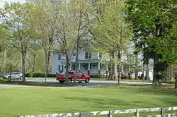 Thomas Claiborne Creasy House |
February 17, 2015 (#15000018) |
415 S. Main St. 36°56′54″N 79°21′40″W |
Gretna | |
| 9 | Gretna Commercial Historic District | 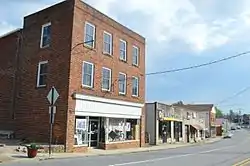 Gretna Commercial Historic District |
May 28, 2013 (#13000342) |
N. and S. Main St., and Henry St. 36°57′07″N 79°21′40″W |
Gretna | 26 contributing buildings.[7] |
| 10 | Hargrave Military Academy | 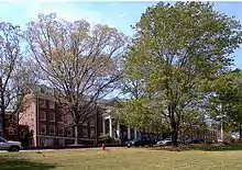 Hargrave Military Academy |
January 24, 2020 (#100004652) |
200 Military Dr. 36°49′56″N 79°24′00″W |
Chatham | |
| 11 | Hill Grove School | 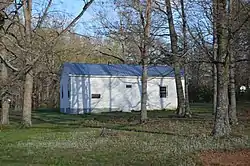 Hill Grove School |
February 25, 2004 (#04000104) |
2580 Wards Rd. 37°04′04″N 79°14′57″W |
Hurt | |
| 12 | Leesville Dam Archeological Site (44PY30) | November 2, 1989 (#89001916) |
Address Restricted |
Altavista | ||
| 13 | Little Cherrystone | 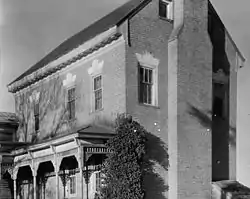 Little Cherrystone |
November 12, 1969 (#69000269) |
North of the junction of State Route 57 and Fairview Rd. 36°49′11″N 79°20′58″W |
Chatham | |
| 14 | Locust Hill |  Locust Hill |
November 27, 2002 (#02001449) |
7408 Wards Rd. 37°06′47″N 79°14′41″W |
Hurt | |
| 15 | Mountain View |  Mountain View |
September 10, 1979 (#79003066) |
2 miles south of Chatham on Tight Squeeze Rd. 36°46′56″N 79°24′13″W |
Chatham | |
| 16 | Oak Ridge |  Oak Ridge |
August 28, 2017 (#100001515) |
2345 U.S. Route 311 36°34′52″N 79°32′43″W |
Danville | |
| 17 | Pittsylvania County Courthouse | _(2).jpg.webp) Pittsylvania County Courthouse |
October 29, 1981 (#81000643) |
U.S. Route 29 Business 36°49′35″N 79°23′54″W |
Chatham | |
| 18 | Southside High School | August 7, 2020 (#100005430) |
200 Blairs Middle School Cir. 36°41′20″N 79°22′16″W |
Blairs | Now the middle school? | |
| 19 | Windsor | 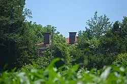 Windsor |
July 30, 1980 (#80004211) |
Mountain Run Rd.[8] 36°32′49″N 79°38′25″W |
Cascade | |
| 20 | Yates Tavern | 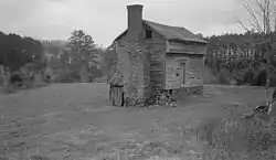 Yates Tavern |
December 19, 1974 (#74002143) |
South of Gretna on U.S. Route 29 Business 36°56′08″N 79°22′01″W |
Gretna | |
| 21 | John and Nancy Yeatts House | 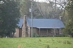 John and Nancy Yeatts House |
March 25, 2009 (#09000173) |
Emery Rd. 36°53′39″N 79°25′40″W |
Chatham |
Former listings
| [3] | Name on the Register | Image | Date listed | Date removed | Location | City or town | Summary |
|---|---|---|---|---|---|---|---|
| 1 | Oak Hill |  Oak Hill |
December 28, 1979 (#79003068) | March 19, 2001 | VA 863 |
Oak Ridge | Destroyed by fire in 1988 |
| 2 | Woodlawn | 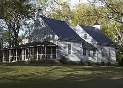 Woodlawn |
May 26, 2005 (#05000478) | February 21, 2017 | 5321 Henrys Mill Rd. 36°46′31″N 79°09′48″W |
Vernon Hill |
See also
| Wikimedia Commons has media related to National Register of Historic Places in Pittsylvania County, Virginia. |
References
- The latitude and longitude information provided in this table was derived originally from the National Register Information System, which has been found to be fairly accurate for about 99% of listings. Some locations in this table may have been corrected to current GPS standards.
- "National Register of Historic Places: Weekly List Actions". National Park Service, United States Department of the Interior. Retrieved on January 29, 2021.
- Numbers represent an alphabetical ordering by significant words. Various colorings, defined here, differentiate National Historic Landmarks and historic districts from other NRHP buildings, structures, sites or objects.
- "National Register Information System". National Register of Historic Places. National Park Service. April 24, 2008.
- The eight-digit number below each date is the number assigned to each location in the National Register Information System database, which can be viewed by clicking the number.
- "Historical building burns". The News & Advance 2017-04-20: C1, C3: C1.
- NPS
- Virginia Historic Landmarks Commission Staff. National Register of Historic Places Inventory/Nomination: Windsor. National Park Service, 1980-04, 7.

This article is issued from Wikipedia. The text is licensed under Creative Commons - Attribution - Sharealike. Additional terms may apply for the media files.