National Register of Historic Places listings in Lexington, Virginia
This is a list of the National Register of Historic Places listings in Lexington, Virginia.
Location of Lexington in Virginia
This is intended to be a complete list of the properties and districts on the National Register of Historic Places in the independent city of Lexington, Virginia, United States. The locations of National Register properties and districts for which the latitude and longitude coordinates are included below, may be seen in a Google map.[1]
There are 17 properties and districts listed on the National Register in the city, including 4 National Historic Landmarks.
- This National Park Service list is complete through NPS recent listings posted January 29, 2021.[2]
Current listings
| [3] | Name on the Register[4] | Image | Date listed[5] | Location | Description |
|---|---|---|---|---|---|
| 1 | Alexander-Withrow House | 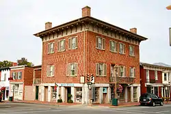 Alexander-Withrow House |
July 2, 1971 (#71001055) |
Main and Washington Streets 37°47′07″N 79°26′31″W |
|
| 2 | Barracks, Virginia Military Institute | .jpg.webp) Barracks, Virginia Military Institute |
October 15, 1966 (#66000956) |
Northern edge of Lexington on U.S. Route 11 37°47′26″N 79°26′06″W |
|
| 3 | Blandome |  Blandome |
January 24, 2002 (#01001520) |
101 Tucker St. 37°47′04″N 79°26′20″W |
|
| 4 | Col Alto |  Col Alto |
November 19, 1990 (#89001925) |
Nelson and Spottswood Dr. 37°46′49″N 79°26′19″W |
|
| 5 | Lylburn Downing School | 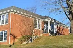 Lylburn Downing School |
October 23, 2003 (#03001093) |
300 Diamond St. 37°47′11″N 79°26′06″W |
|
| 6 | First Baptist Church | 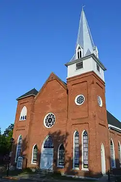 First Baptist Church |
August 30, 2006 (#06000757) |
103 N. Main St. 37°47′10″N 79°26′26″W |
|
| 7 | Stonewall Jackson House | 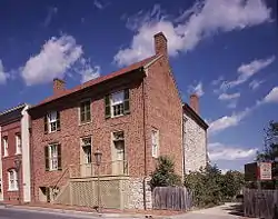 Stonewall Jackson House |
April 24, 1973 (#73002215) |
8 E. Washington St. 37°47′05″N 79°26′29″W |
|
| 8 | Jordan's Point Historic District |  Jordan's Point Historic District |
August 15, 2016 (#16000530) |
Moses Mill Rd. and the confluence of the Maury River and Woods Creek 37°47′32″N 79°25′47″W |
|
| 9 | Lee Chapel, Washington and Lee University |  Lee Chapel, Washington and Lee University |
October 15, 1966 (#66000914) |
Washington and Lee University campus 37°47′15″N 79°26′31″W |
|
| 10 | Lexington and Covington Turnpike Toll House |  Lexington and Covington Turnpike Toll House |
November 27, 2004 (#04001268) |
453 Lime Kiln Rd. 37°47′13″N 79°27′14″W |
|
| 11 | Lexington Historic District | 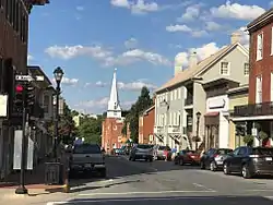 Lexington Historic District |
July 26, 1972 (#72001506) |
Roughly bounded by the former Chesapeake and Ohio railroad line, Graham and Jackson Aves., and Estill and Jordan Sts. 37°47′09″N 79°26′25″W |
Includes several other listings, such as Washington and Lee University, Virginia Military Institute, Alexander-Withrow House, and Lexington Presbyterian Church |
| 12 | Lexington Presbyterian Church | 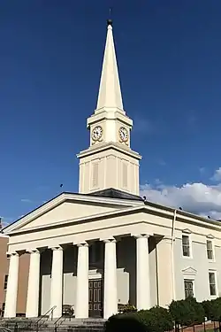 Lexington Presbyterian Church |
May 24, 1979 (#79003282) |
Main and Nelson Streets 37°47′02″N 79°26′34″W |
|
| 13 | Mulberry Hill |  Mulberry Hill |
September 9, 1982 (#82004671) |
Liberty Hall Rd. 37°47′25″N 79°26′59″W |
|
| 14 | Reid-White-Philbin House |  Reid-White-Philbin House |
August 2, 2000 (#00000889) |
208 W. Nelson St. 37°47′08″N 79°26′45″W |
|
| 15 | Stono |  Stono |
April 1, 1975 (#75002112) |
At the junction of U.S. Routes 11 and 11 Alt. 37°47′26″N 79°25′51″W |
|
| 16 | Virginia Military Institute Historic District |  Virginia Military Institute Historic District |
May 30, 1974 (#74002219) |
Virginia Military Institute campus 37°47′24″N 79°26′09″W |
|
| 17 | Washington and Lee University Historic District | Washington and Lee University Historic District |
November 11, 1971 (#71001047) |
Washington and Lee University campus 37°47′17″N 79°26′33″W |
See also
| Wikimedia Commons has media related to National Register of Historic Places in Lexington, Virginia. |
References
- The latitude and longitude information provided in this table was derived originally from the National Register Information System, which has been found to be fairly accurate for about 99% of listings. Some locations in this table may have been corrected to current GPS standards.
- "National Register of Historic Places: Weekly List Actions". National Park Service, United States Department of the Interior. Retrieved on January 29, 2021.
- Numbers represent an alphabetical ordering by significant words. Various colorings, defined here, differentiate National Historic Landmarks and historic districts from other NRHP buildings, structures, sites or objects.
- "National Register Information System". National Register of Historic Places. National Park Service. April 24, 2008.
- The eight-digit number below each date is the number assigned to each location in the National Register Information System database, which can be viewed by clicking the number.

This article is issued from Wikipedia. The text is licensed under Creative Commons - Attribution - Sharealike. Additional terms may apply for the media files.