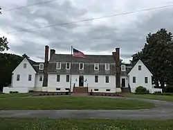
Windsor Shades
Windsor Shades (also known as Ruffin's Ferry and Waterville) is located on the Pamunkey River in Sweet Hall, Virginia, United States, that is listed on the National Register of Historic Places. Archeological native artifacts found on the property surrounding the house suggest it was the site of Kupkipcok, a Pamunkey village noted on John Smith's 1609 map.[3][4]
Windsor Shades | |
 Windsor Shades in 2018 | |
  | |
| Location | Sweet Hall, Virginia United States |
|---|---|
| Coordinates | 37°34′13″N 76°54′35″W |
| Area | 14 acres (5.7 ha) |
| Built | 1745-1755 |
| NRHP reference No. | 78003025 [1] |
| VLR No. | 050-0070 |
| Significant dates | |
| Added to NRHP | May 22, 1978 |
| Designated VLR | December 21, 1976[2] |
Description
.jpg.webp)
The land title is not clear, owing to the destruction of King William County records, but the house is assumed to have been built around 1750.[5] The building is a story-and-a-half, 5 bay gambled roofed, frame structure covered with beaded weatherboards and set on a low, stone and English-bond brick basement. The house has striking massive Flemish - bond brick chimney stacks at either end. In the basement is a large tavern room with reportedly one of the largest interior cooking hearths in Tidewater, Virginia.[6] The site was listed on the National Register of Historic Places in 1978.[7] In 1999 two wings were added on either side of the main block with little alteration of the original structure.
In 1754 Captain Thomas Dansie established a ferry at the site and operated a tavern in the house.[8] The ferry was in operation until 1927 when a bridge was built in West Point. During the years the house was operated as a tavern with a ferry crossing it was frequented by many notable travelers such as George Washington, who patronized it from the 1750s on his Burgess Route to Williamsburg.[9] In August 1781, the Marquis de Lafayette crossed the Pamunkey by ferry with 4,500 troops. He spent two weeks in King William County, moving between Windsor Shades and Chelsea Plantation.[10] On September 13, 1781 Washington and Rochambeau crossed the Pamunkey at Ruffin's Ferry headed to the battle of Yorktown.[11]
The current owners purchased the property in 1998 and in 2009 donated a historic easement on Windsor Shades and the 14 acres the house sits on to the Virginia Department of Historic Resources.[12]
References
- "National Register Information System". National Register of Historic Places. National Park Service. March 13, 2009.
- "Virginia Landmarks Register". Virginia Department of Historic Resources. Retrieved 5 June 2013.
- Helen C. Roundtree, Wayne E. Clark and Kent Mountford. John Smith's Chesapeake Voyages 1607-1609, Charlottesville, University of Virginia Press, 2007.
- Virginia Department of Historic Resources, Richmond, Archeological Report- Site 44 KW 0275, April 2, 2007.
- Virginia Historical Society Landmark Commission staff, National Register of Historic Places Inventory/Nomination: Windsor Shades Department of Historical Resources, December 1976.
- Francis Archer Christian and Susanne Williams Massie editors, Homes and Gardens in Old Virginia, Richmond, Jarrett and Massie Incorporated, 1950. pp255-258
- National Park Services, United States Department of the Interior, National Register of Historic Places- Listing 780 0 3025
- Malcolm H. Harris, Old New Kent County, Some Account of the Planters, Plantations, and Places in New Kent County, Volume 2. West Point, Virginia, Malcolm Hart Harris, MD, 1977. pp 606-607.
- John R. Maass, George Washington's Virginia, Charleston, South Carolina. The History Press, 2017, p. 153.
- Bulletin of the King William County Historical Society, October 1976, King William, Virginia.
- Virginia Department of Historic Resources, Revolutionary War Route and Transportation Survey in the Commonwealth of Virginia, 1781-1782, DHR-CRM Report VA-078, Richmond, 2009.
- Virginia Department of Historic Resources CD HR File # 050-0070, Richmond, Virginia, January 13, 2009.
External links
| Wikimedia Commons has media related to Windsor Shades. |
- Windsor Shade, Pamunkey River, Johnson Landing, King William County, VA: 1 photo at Historic American Buildings Survey

