National Register of Historic Places listings in Perry County, Pennsylvania
This is a list of the National Register of Historic Places listings in Perry County, Pennsylvania.

Location of Perry County in Pennsylvania
This is intended to be a complete list of the properties and districts on the National Register of Historic Places in Perry County, Pennsylvania, United States. The locations of National Register properties and districts for which the latitude and longitude coordinates are included below, may be seen in a map.[1]
There are 21 properties and districts listed on the National Register in the county.
- This National Park Service list is complete through NPS recent listings posted January 29, 2021.[2]
Current listings
| [3] | Name on the Register | Image | Date listed[4] | Location | City or town | Description |
|---|---|---|---|---|---|---|
| 1 | Adairs Covered Bridge | 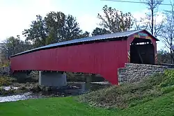 Adairs Covered Bridge |
August 25, 1980 (#80003594) |
East of Andersonburg on Legislative Route 50009 40°21′02″N 77°25′27″W |
Southwest Madison Township | |
| 2 | Bistline Covered Bridge | 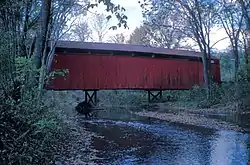 Bistline Covered Bridge |
August 25, 1980 (#80003591) |
South of Andersonburg on Legislative Route 50008 40°20′02″N 77°28′14″W |
Southwest Madison Township | |
| 3 | Book's Covered Bridge |  Book's Covered Bridge |
August 25, 1980 (#80003592) |
Southwest of Blain on Legislative Route 50004 40°19′28″N 77°31′29″W |
Jackson Township | |
| 4 | Bridge in Newport Borough | 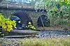 Bridge in Newport Borough |
June 22, 1988 (#88000854) |
Legislative Route 34 over Little Buffalo Creek 40°28′27″N 77°07′48″W |
Newport and Oliver Township | |
| 5 | Dellville Covered Bridge |  Dellville Covered Bridge |
August 25, 1980 (#80003593) |
Township 456 40°21′49″N 77°07′00″W |
Wheatfield Township | |
| 6 | Dunbar-Creigh House | 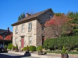 Dunbar-Creigh House |
June 27, 1980 (#80003595) |
Water Street 40°20′30″N 77°18′25″W |
Landisburg | |
| 7 | Fleisher Covered Bridge | 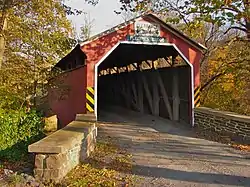 Fleisher Covered Bridge |
August 25, 1980 (#80003601) |
Northwest of Newport on Township 477 40°29′22″N 77°09′31″W |
Oliver Township | |
| 8 | Kochendefer Covered Bridge |  Kochendefer Covered Bridge |
August 25, 1980 (#80003602) |
Southeast of Saville on Township 332 40°25′27″N 77°23′15″W |
Saville Township | |
| 9 | Little Buffalo Historic District | 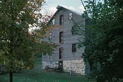 Little Buffalo Historic District |
April 3, 1978 (#78002440) |
Southwest of Newport off Pennsylvania Route 34 40°27′19″N 77°10′13″W |
Centre and Juniata Townships | |
| 10 | Israel and Samuel Lupfer Tannery Site and House |  Israel and Samuel Lupfer Tannery Site and House |
May 30, 2003 (#03000493) |
Black Hollow Road 40°16′54″N 77°32′02″W |
Jackson and Toboyne Townships | |
| 11 | Millersburg Ferry |  Millersburg Ferry |
August 2, 2006 (#06000663) |
Over the Susquehanna River between Millersburg and Buffalo Township 40°32′39″N 76°58′25″W |
Buffalo Township | Extends into Millersburg in Dauphin County |
| 12 | Mt. Pleasant Covered Bridge | 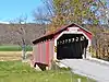 Mt. Pleasant Covered Bridge |
August 25, 1980 (#80003599) |
East of New Germantown on Township 304 40°18′54″N 77°32′44″W |
Jackson Township | |
| 13 | New Germantown Covered Bridge | 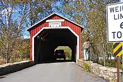 New Germantown Covered Bridge |
August 25, 1980 (#80003600) |
South of New Germantown on Township 302 40°18′24″N 77°34′06″W |
Jackson Township | |
| 14 | Newport Historic District | 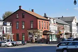 Newport Historic District |
March 12, 1999 (#99000321) |
Roughly bounded by Fickes Lane, Oliver Street, Front Street, Little Buffalo Run, Bloomfield Avenue, and Sixth Street 40°28′39″N 77°07′58″W |
Newport and Oliver Township | |
| 15 | O'Donel House and Farm | 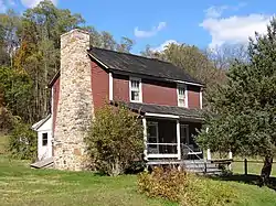 O'Donel House and Farm |
July 17, 1986 (#86001687) |
West of New Germantown on Pennsylvania Route 274 40°16′53″N 77°37′19″W |
Toboyne Township | |
| 16 | Perry County Courthouse | 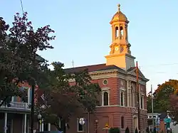 Perry County Courthouse |
February 24, 1975 (#75001659) |
Center Square 40°25′12″N 77°11′15″W |
Bloomfield | |
| 17 | Red Covered Bridge | 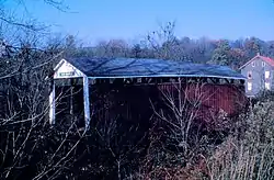 Red Covered Bridge |
August 25, 1980 (#80003597) |
East of Millerstown on Legislative Route 50023 40°33′58″N 77°00′14″W |
Liverpool Township | |
| 18 | Rice Covered Bridge | 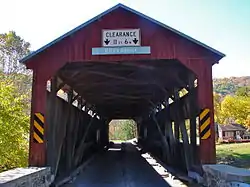 Rice Covered Bridge |
August 25, 1980 (#80003596) |
South of Landisburg on Legislative Route 50023 40°20′09″N 77°18′34″W |
Tyrone Township | |
| 19 | Rockville Bridge | 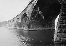 Rockville Bridge |
August 15, 1975 (#75001640) |
0.5 miles south of central Marysville over the Susquehanna River 40°19′59″N 76°54′42″W |
Marysville | Extends into Dauphin County |
| 20 | Saville Covered Bridge | 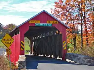 Saville Covered Bridge |
August 25, 1980 (#80003603) |
Legislative Route 50037 40°26′17″N 77°23′47″W |
Saville Township | |
| 21 | Waggoner Covered Bridge | 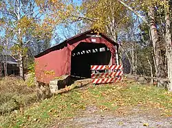 Waggoner Covered Bridge |
August 25, 1980 (#80003598) |
West of Loysville on Township 579 40°21′34″N 77°22′23″W |
Northeast Madison Township |
See also
| Wikimedia Commons has media related to National Register of Historic Places in Perry County, Pennsylvania. |
References
- The latitude and longitude information provided in this table was derived originally from the National Register Information System, which has been found to be fairly accurate for about 99% of listings. Some locations in this table may have been corrected to current GPS standards.
- "National Register of Historic Places: Weekly List Actions". National Park Service, United States Department of the Interior. Retrieved on January 29, 2021.
- Numbers represent an alphabetical ordering by significant words. Various colorings, defined here, differentiate National Historic Landmarks and historic districts from other NRHP buildings, structures, sites or objects.
- The eight-digit number below each date is the number assigned to each location in the National Register Information System database, which can be viewed by clicking the number.
Municipalities and communities of Perry County, Pennsylvania, United States | ||
|---|---|---|
| Boroughs | | |
| Townships | ||
| Unincorporated communities | ||
| ||
| Topics |  | |
|---|---|---|
| Lists by county |
| |
| Lists by city | ||
| Other lists | ||
| ||
This article is issued from Wikipedia. The text is licensed under Creative Commons - Attribution - Sharealike. Additional terms may apply for the media files.