National Register of Historic Places listings in Carbon County, Pennsylvania
This is a list of the National Register of Historic Places listings in Carbon County, Pennsylvania.
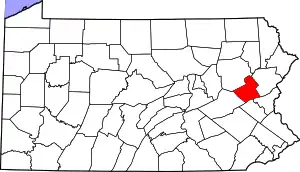
Location of Carbon County in Pennsylvania
This is intended to be a complete list of the properties and districts on the National Register of Historic Places in Carbon County, Pennsylvania, United States. The locations of National Register properties and districts for which the latitude and longitude coordinates are included below, may be seen in a map.[1]
There are 14 properties and districts listed on the National Register in the county. Two sites are further designated as National Historic Landmarks.
- This National Park Service list is complete through NPS recent listings posted January 29, 2021.[2]
Current listings
| [3] | Name on the Register | Image | Date listed[4] | Location | City or town | Description |
|---|---|---|---|---|---|---|
| 1 | Carbon County Jail | 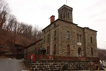 Carbon County Jail |
November 8, 1974 (#74001764) |
128 Broadway Street 40°51′50″N 75°44′49″W |
Jim Thorpe | John Haviland & Henry Bowman, architects. |
| 2 | Carbon County Section of the Lehigh Canal |  Carbon County Section of the Lehigh Canal |
August 10, 1979 (#79002179) |
Along the Lehigh River 40°49′03″N 75°40′08″W |
Bowmanstown, Franklin Township, Jim Thorpe, Lower Towamensing Township, Palmerton, Parryville, and Weissport | Extends into Lehigh Township and Walnutport in Northampton County |
| 3 | Central Railroad of New Jersey Station |  Central Railroad of New Jersey Station |
January 1, 1976 (#76001615) |
Susquehanna Street 40°51′46″N 75°44′19″W |
Jim Thorpe | Wilson Brothers & Company, architects. |
| 4 | The Grotto-Our Lady of Lourdes Shrine | 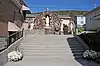 The Grotto-Our Lady of Lourdes Shrine |
September 20, 2019 (#11000923) |
15 E. Garibaldi Ave. 40°52′09″N 75°48′55″W |
Nesquehoning | |
| 5 | Lansford Historic District | 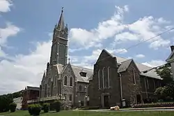 Lansford Historic District |
September 4, 2012 (#12000605) |
Roughly bounded by Snyder Avenue, Cortright, East, and Water Streets 40°49′53″N 75°53′00″W |
Lansford | |
| 6 | Little Gap Covered Bridge | 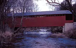 Little Gap Covered Bridge |
December 1, 1980 (#80004294) |
South of Little Gap on Township 376 40°49′52″N 75°31′22″W |
Lower Towamensing Township | |
| 7 | Mauch Chunk Switchback Railway | 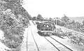 Mauch Chunk Switchback Railway |
June 3, 1976 (#76001616) |
Between Ludlow Street in Summit Hill and F.A.P. 209 in Jim Thorpe 40°50′58″N 75°47′46″W |
Jim Thorpe, Nesquehoning, and Summit Hill | |
| 8 | Nesquehoning High School | 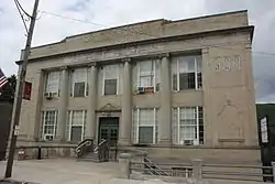 Nesquehoning High School |
November 21, 2003 (#03001187) |
120–124 East Catawissa Street 40°51′55″N 75°48′35″W |
Nesquehoning | |
| 9 | Old Mauch Chunk Historic District | 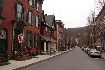 Old Mauch Chunk Historic District |
November 10, 1977 (#77001134) |
Broadway, Susquehanna, Race, and High Streets 40°51′44″N 75°44′35″W |
Jim Thorpe | |
| 10 | Asa Packer Mansion | 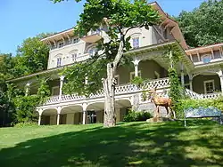 Asa Packer Mansion |
December 30, 1974 (#74001765) |
Packer Road 40°51′50″N 75°44′16″W |
Jim Thorpe | Attributed to Samuel Sloan, architect. |
| 11 | Harry Packer Mansion |  Harry Packer Mansion |
November 20, 1974 (#74001766) |
Packer Road 40°51′53″N 75°44′17″W |
Jim Thorpe | Addison Hutton, architect. |
| 12 | Palmerton Historic District | 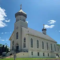 Palmerton Historic District |
January 19, 2018 (#13000743) |
Roughly bounded by Ave. A, Harvard Ave., 8th & Tomb Sts. 40°48′16″N 75°36′32″W |
Palmerton | |
| 13 | St. Mark's Episcopal Church | .jpg.webp) St. Mark's Episcopal Church |
July 26, 1977 (#77001135) |
Race and Susquehanna Streets 40°51′46″N 75°44′21″W |
Jim Thorpe | Richard Upjohn, architect. |
| 14 | Summit Hill High School | 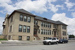 Summit Hill High School |
February 16, 2001 (#01000138) |
124 West Hazard Street 40°49′34″N 75°52′29″W |
Summit Hill |
See also
| Wikimedia Commons has media related to National Register of Historic Places in Carbon County, Pennsylvania. |
References
- The latitude and longitude information provided in this table was derived originally from the National Register Information System, which has been found to be fairly accurate for about 99% of listings. Some locations in this table may have been corrected to current GPS standards.
- "National Register of Historic Places: Weekly List Actions". National Park Service, United States Department of the Interior. Retrieved on January 29, 2021.
- Numbers represent an alphabetical ordering by significant words. Various colorings, defined here, differentiate National Historic Landmarks and historic districts from other NRHP buildings, structures, sites or objects.
- The eight-digit number below each date is the number assigned to each location in the National Register Information System database, which can be viewed by clicking the number.
| Topics |  | |
|---|---|---|
| Lists by county |
| |
| Lists by city | ||
| Other lists | ||
| ||
Municipalities and communities of Carbon County, Pennsylvania, United States | ||
|---|---|---|
| Boroughs | | |
| Townships | ||
| CDPs | ||
| Unincorporated communities | ||
| Footnotes | ‡This populated place also has portions in an adjacent county or counties | |
| ||
This article is issued from Wikipedia. The text is licensed under Creative Commons - Attribution - Sharealike. Additional terms may apply for the media files.