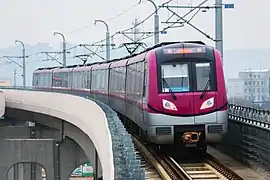
Line S3 (Nanjing Metro)
Line S3 of the Nanjing Metro (Chinese: 南京地铁S3号线; pinyin: Nánjīng Dìtiě S-Sān Hào Xiàn), is a north-south suburban rapid transit line serving part of the southern and southwestern suburbs of Nanjing, running from Nanjing South Railway Station and Gaojiachong. It is the first line of the Nanjing Metro with passing tracks at select stations, allowing from distinct express local services. The first phase of the project is 36.22 km (22.51 mi) long with 19 stations, including 10 underground stations, 8 elevated stations and 1 ground station.[3] The line crosses the Yangtze River using the Dashengguan Yangtze River Bridge. In 2012, the first phase of the project was approved by the NDRC for construction with the first section started construction on 27 December 2012.[4][5] On August 13, 2017, the first phase of Line S3 started to be unmanned testing.[6] The first phase of the line was completed by the end of 2017 and started trial operation on 6 December 2017.[7]
| Line S3 | |
|---|---|
| S3 | |
 | |
| Overview | |
| Other name(s) | Nanjing–He County intercity railway[1] Ninghe intercity railway[2][lower-alpha 1] |
| Status | In operation |
| Locale | Yuhuatai, Jianye and Pukou districts Nanjing, Jiangsu |
| Termini | Nanjing South Railway Station Gaojiachong |
| Stations | 19 |
| Service | |
| Type | Rapid transit |
| System | Nanjing Metro |
| History | |
| Opened | 6 December 2017 |
| Technical | |
| Line length | 36.26 km (22.5 mi) |
| Number of tracks | 2 |
| Character | Underground and Elevated |
| Track gauge | 1,435 mm (4 ft 8 1⁄2 in) |
Opening timeline
| Segment | Commencement | Length | Station(s) | Name |
|---|---|---|---|---|
| Nanjing South — Gaojiachong | 6 December 2017 | 36.26 km (22.53 mi) | 19 | Ninghe ICR Phase 1 |
Station list
| Station name | Connections | Distance km |
Location | ||
|---|---|---|---|---|---|
| English | Chinese | ||||
| Nanjing South Railway Station | 南京南站 | 1 3 S1 NKH | 0.000 | 0.000 | Yuhuatai |
| Jingmingjiayuan | 景明佳园 | 1.963 | 1.963 | ||
| Tiexinqiao | 铁心桥 | 1.470 | 3.433 | ||
| Chunjianglu | 春江路 | 1.507 | 4.940 | ||
| Jiaxi | 贾西 | 1.446 | 6.386 | ||
| Youfangqiao | 油坊桥 | 2 | 1.608 | 7.994 | Jianye |
| Yongchulu | 永初路 | 1.187 | 9.181 | ||
| Pingliangdajie | 平良大街 | 1.154 | 10.335 | ||
| Wuhoujie | 吴侯街 | 0.949 | 11.284 | ||
| Gaomiaolu | 高庙路 | 1.037 | 12.321 | ||
| Tianbao | 天保 | 2.007 | 14.328 | Yuhuatai | |
| Liucun | 刘村 | 1.525 | 15.853 | ||
| Maluowei | 马骡圩 | 9.844 | 25.697 | Pukou | |
| Lanhuatang | 兰花塘 | 2.099 | 27.796 | ||
| Shuanglong | 双垅 | 1.324 | 29.120 | ||
| Shiqihe | 石碛河 | 1.471 | 30.591 | ||
| Qiaolinxincheng | 桥林新城 | 1.350 | 31.941 | ||
| Linshan | 林山 | 1.998 | 33.939 | ||
| Gaojiachong | 高家冲 | 1.712 | 35.651 | ||
References
- simplified Chinese: 南京到和县城际轨道交通; traditional Chinese: 南京到和縣城際軌道交通; pinyin: Nánjīng dào Héxiàn Chéngjì Guǐdào Jiāotōng)
- 宁和城际轨道交通; 寧和城際軌道交通; Níng-Hé Chéngjì Guǐdào Jiāotōng
- 南京地铁. www.njmetro.com.cn. Retrieved 2017-12-09.
- "Archived copy" 宁和城际轨道交通一期工程监理NH-JL-04标. www.bidchance.com. Archived from the original on 2014-05-17. Retrieved 2017-12-09.CS1 maint: archived copy as title (link)
- Xing Si (幸禠). "Archived copy" 宁和城际铁路十二标大应变桩基检测通过(图)_中国铁路_中国网. railway.china.com.cn. Archived from the original on 2017-02-11. Retrieved 2017-12-09.CS1 maint: archived copy as title (link)
- "Archived copy" 宁和城际轨道交通一期工程开始不载客试运行-新华网. www.js.xinhuanet.com. Archived from the original on 2017-08-13. Retrieved 2017-12-09.CS1 maint: archived copy as title (link)
- 南京城际地铁开跑 苏州、上海跨省城际加快推进-新华网. www.js.xinhuanet.com. Retrieved 2017-12-09.
- "Ning" (宁), is the standard Chinese abbreviation for Nanjing. It comes from the name "Jiangning" (江宁) that the city had in the early Qing.