Upper Mount Gravatt, Queensland
Upper Mount Gravatt is a suburb in the City of Brisbane, Queensland, Australia.[3]
| Upper Mount Gravatt Brisbane, Queensland | |||||||||||||||
|---|---|---|---|---|---|---|---|---|---|---|---|---|---|---|---|
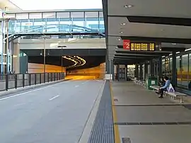
 Busway station | |||||||||||||||
 Upper Mount Gravatt | |||||||||||||||
| Coordinates | 27.5552°S 153.0797°E | ||||||||||||||
| Population | 9,241 (2016 census)[1] | ||||||||||||||
| • Density | 1,925/km2 (4,990/sq mi) | ||||||||||||||
| Postcode(s) | 4122 | ||||||||||||||
| Area | 4.8 km2 (1.9 sq mi) | ||||||||||||||
| Location | 12 km (7 mi) south-east of Brisbane CBD | ||||||||||||||
| LGA(s) | City of Brisbane (MacGregor Ward)[2] | ||||||||||||||
| State electorate(s) | Mansfield | ||||||||||||||
| Federal Division(s) | Bonner | ||||||||||||||
| |||||||||||||||
Geography
Upper Mount Gravatt is south of Mount Gravatt. It has increasingly become an important centre in the last 15 years. In terms of infrastructure, Logan Road and the Pacific Motorway run through it, in addition to the South-East Busway.

Together with Indooroopilly in the west, Chermside, on the north-side, and Carindale in the southeast the suburb has been described as a mini-Central business district (CBD). It contains the State Netball Centre, a major police district station and a regional Australian Taxation Office.
Upper Mount Gravatt has long been one of the major centres outside the CBD, especially for those who reside on the south of the city.
Westfield Garden City, a major shopping centre, is a regional "hub", containing services and popular restaurants, with a bus interchange and the Upper Mount Gravatt Busway Station immediately below it.
History
Westfield Garden City opened in 1970. The Garden City Library was established by the Brisbane City Council as one of the initial tenants and the library had a major refurbishment in 1996.[4]
Mount Gravatt Special School opened on 17 May 1971.[5]
Demographics
In the 2011 census, the population of Upper Mount Gravatt was 8,851, 51.1% female and 48.9% male. The median age of the Upper Mount Gravatt population was 34 years, 3 years below the Australian median. 59.4% of people living in Upper Mount Gravatt were born in Australia, compared to the national average of 69.8%; the next most common countries of birth were New Zealand 3.3%, China 3.1%, India 2.9%, England 2.7%, Korea, Republic of 1.4%. 67% of people spoke only English at home; the next most common languages were 4.1% Mandarin, 2% Cantonese, 1.4% Korean, 1.4% Arabic, 1.1% Greek.
Education
- Clairvaux MacKillop College
- Upper Mount Gravatt Primary School
- Saint Bernards Catholic School
- Saint Catherine's Catholic School
Amenities
.jpg.webp)
The Brisbane City Council operates a public library at Westfield Garden City.[6]
Sport
Upper Mount Gravatt is also home to the Mount Gravatt Vultures, a Queensland Australian Football League Club on Klumpp Road.[7] The club were premiers in 2007.[8] There is also the Hibiscus Sporting Complex and the Mount Gravatt PCYC on the same road.
References
- Australian Bureau of Statistics (27 June 2017). "Upper Mount Gravatt (State Suburb)". 2016 Census QuickStats. Retrieved 16 February 2014.

- "MacGregor Ward". Brisbane City Council. Brisbane City Council. Retrieved 12 March 2017.
- "Upper Mount Gravatt – suburb in City of Brisbane (entry 47606)". Queensland Place Names. Queensland Government. Retrieved 5 November 2017.
- "Public Libraries Statistical Bulletin 2016-17" (PDF). Public Libraries Connect. State Library of Queensland. November 2017. p. 11. Archived (PDF) from the original on 30 January 2018. Retrieved 30 January 2018.
- Queensland Family History Society (2010), Queensland schools past and present (Version 1.01 ed.), Queensland Family History Society, ISBN 978-1-921171-26-0
- "Library opening hours and locations". Brisbane City Council. 3 January 2018. Archived from the original on 30 January 2018. Retrieved 30 January 2018.
- "Mt Gravatt Vultures".
- "AFL Queensland Premiers".