List of crossings of the Shannon
This is a list of crossings of the Shannon river, in Ireland (including bridges, tunnels, ferries and fords), from its source in the Shannon Pot to the Shannon Estuary where the river widens before it flows into the Atlantic Ocean. Bridges not primarily intended for public use but which have limited access (generally only in the daytime and only for bicycle and foot traffic) are not included.
Crossings
In order, moving downstream:
| Crossing | Date | Coordinates | Heritage status |
Locality | Notes | Image |
|---|---|---|---|---|---|---|
| The source of the River Shannon | 54.23475°N 7.919°W | - | Shannon Pot | Included for completeness | .jpg.webp) | |
| Bradán Feasa footbridge[1][2][3] | 54.2346°N 7.9195°W | - | Shannon Pot, County Cavan | Footbridge, built by the OPW, which crosses the infant Shannon about 20 meters downstream from the Shannon Pot | ||
| Dowra bridge | 1862[4] | 54.1896°N 8.0141°W | - | Dowra, County Cavan | Last crossing above Lough Allen. Carries the R200 between Counties Cavan and Leitrim. | 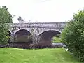 |
| Bellintra bridge[5] | 54.0610°N 8.0598°W | - | Derrynadooey, County Roscommon[5] | First crossing below Lough Allen. Carries a local road (L33783 off the R280) between Counties Roscommon and Leitrim. Above sluice gates operated by the ESB Group.[5] |  | |
| R280 Bridge | 54.0549°N 8.0680°W | - | Aghafin, County Roscommon/Mahanagh, County Leitrim | Carries the R280 between Counties Roscommon and Leitrim. | ||
| Battlebridge | 53.9964°N 8.0786°W | - | Battlebridge, County Roscommon/Drumhierny, County Leitrim | Carries the R284 between Counties Roscommon and Leitrim. | ||
| Hartley bridge[6] | 1915[6] | 53.9672°N 8.095°W | - | Cleaheen County Roscommon, 6km west of Cootehall/County Roscommon, 3 km north of Carrick on Shannon, County Leitrim | Carries a minor road between Counties Roscommon and Leitrim. |  |
| Carrick Bridge[7] | 1846[7] | 53.943°N 8.0958°W | - | Carrick-on-Shannon, County Leitrim | Carries the M4/N4 from through Carrick-on-Shannon crossing between Roscommon and Leitrim. Replaced an earlier bridge.[7] | .jpg.webp) |
| Lough Tap Railway Bridge[8] | 2009[9] | 53.906°N 7.9928°W | - | Lough Tap, Border of Co. Roscommon & Leitrim | Carries the Dublin–Sligo railway line between Counties Roscommon and Leitrim over Lough Tap. Links Dromod and Carrick-on-Shannon railway stations. Replaced existing bridge dated from 1862.[9] | |
| X X | ||||||
| Jamestown Bridge | 1800s | 53.9235°N 8.0298°W | - | East of Jamestown, County Leitrim | First of two bridges carrying the L3656 from Jamestown to Drumsna through the northern tip of County Roscommon | |
| Drumsna Bridge | 1800s | 53.9248°N 8.0113°W | - | Southwest of Drumsna, County Leitrim | Second of two bridges carrying the L3656 from Jamestown to Drumsna through the northern tip of County Roscommon[10] |  |
| X X | ||||||
| Unnamed Jamestown Canal Bridge (1) | 53.9185°N 8.0317°W | - | County Roscommon, 1km south of Jamestown, 2km South West of Drumsna, both in County Leitrim | Carries a minor road from the L3656 Jamestown/Drumsna Road to the L1405 Drumsna/Strokestown Road | ||
| Unnamed Jamestown Canal Bridge (2) | c.1850 | 53.9127°N 8.0183°W | - | Corry, Co. Roscommon | Carries the L1405 from the L3656 Jamestown/Drumsna Road towards Strokestown | .jpg.webp) |
| Roosky Bridge | 1840-1850 | 53.8326°N 7.9187°W | - | Roosky, Co. Roscommon | Carries the R371 between Counties Roscommon and Leitrim through Roosky. |  |
| Tarmonbarry Bridge | 53.7421°N 7.9176°W | - | East of Tarmonbarry, Co. Roscommon | Carries the N5 between Counties Roscommon and Longford. |  | |
| Bord na Móna rail bridge | 53.7006°N 7.9848°W | - | c.2 km North of Lough Ree Power Station, Lanesboro | Private. Narrow-gauge rail line, used to transport peat from bog to nearby power station. | ||
| Lanesboro bridge | 1971 | 53.6743°N 7.9926°W | - | Lanesboro | Last crossing above Lough Ree. Links the twin towns of Lanesborough, on the County Longford (east) side and Ballyleague, on the County Roscommon (west) side of the river. |  |
| Cumann na mBan Bridge[11][12][13][14] | 1991[12] | 53.4322°N 7.9558°W | - | North of Athlone | First crossing below Lough Ree. Carries the M6/N6 Athlone bypass. Previously known as the 'Athlone Relief Road - Shannon Bridge' & 'bypass bridge', renamed in 2015, with a ceremony held in June 2017[11][12][14][13] | |
| White Bridge[15][16][17] | 1850[18] | 53.4272°N 7.9459°W | - | Athlone | c.200 m west of Athlone railway station. The Dublin–Westport/Galway railway line diverges c.200m west of the bridge | 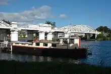 |
| Road Bridge Athlone | 53.4237°N 7.9419°W | - | Athlone | Carries Custume Place (the R446, the old N6 Dublin - Galway Road). Links Athlone Castle and St. Peter and Paul's Church to the Eastern/Leinster side of Athlone | ||
| bridge to Long Island (West bank only) | 53.378085°N 7.9188077°W | - | Long Island, Leamore, County Roscommon | Private local road. Links Long Island to the west bank. | ||
| Shannonbridge | completed in 1757[19] | 53.2797°N 8.0509°W | - | Shannonbridge, County Offaly | Carries R357 from Shannonbridge to County Roscommon | |
| Banagher bridge | 1841–1843 (widened 1971) | 53.1934°N 7.9926°W | - | Northwest of Banagher | Carries the R356 between Counties Offaly and Galway. | 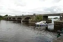 |
| Portumna bridge | 1911 | 53.0911°N 8.1938°W | - | East of Portumna | Last crossing above Lough Derg. Carries the N65 between Counties Tipperary and Galway. Connects Lehinch island to both banks. |  |
| Killaloe Bridge | c.1770[20] | 52.808115°N 8.439110°W | - | Between Ballina, County Tipperary and Killaloe, County Clare | First crossing below Lough Derg. A single lane road bridge linking Counties Tipperary and Clare | 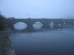 |
| X X | ||||||
| O'Briensbridge (Shannon) | 1780 - 1810[21] | 52.7522°N 8.4985°W | - | East of the village of O'Briensbridge, Co. Clare | Carries the R466 from O'Briensbridge, Co. Clare into Montpelier, County Limerick. Replaced former bridge around 1750, partially replaced in 1842, and modified to include a navigation arch in the 1920s.[22] | 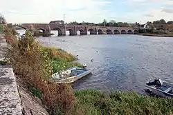 |
| X X | ||||||
| The Living Bridge | 2007 | 52.6768°N 8.5702°W | - | University of Limerick main campus | Pedestrian bridge. Links the main campus on the south bank (in County Limerick) to student residences on the north bank (in County Clare). | 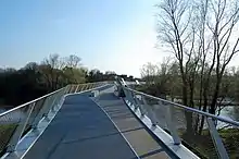 |
| University Bridge | 2004 | 52.678°N 8.5763°W | - | University of Limerick main campus | Links the main campus on the south bank (in County Limerick) to student residences on the north bank (in County Clare). | .jpg.webp) |
| Black Bridge/ "Plassey Bridge"[23] |
1840s | 52.678088°N 8.580037°W | - | Plassey, County Limerick | Pedestrian bridge links Thomond Village, County Clare to the old mill works at Plassey, County Limerick | |
| X X | ||||||
| Errina bridge[24] | 52.7331°N 8.5333°W | - | Errina, County Clare | Close to the Ardnacrusha canal (which is (c.100m to the north)). | ||
| bridge at Gillogue | 52.6859°N 8.572°W | - | East of Gillogue office park, County Clare | Narrow single lane stone bridge. Unmarked lane. | ||
| Parteen Railway Bridge[25] | 2010 | 52.6813°N 8.6279°W | - | Thomondgate, County Limerick | Carries the Limerick-Galway railway line. Used until 1980s for Limerick-Claremorris line. Restored in early 2008. | |
| Athlunkard Bridge | 1825 - 1830[26] | 52.6812°N 8.6099°W | - | Corbally, Co. Limerick | Carries the R463 between Corbally Road on the outskirts of Limerick city and Athlunkard Avenue in Corbally, County Clare. | |
| X X | ||||||
| canal bridge, O'Briensbridge | 52.753°N 8.5068°W | - | West of the village of O'Briensbridge, Co. Clare | Carries the R466 from O'Briensbridge into Bridgetown | ||
| Ardnacrusha power plant | 1928 | 52.705594°N 8.612313°W | - | Southwest of Ardnacrusha within County Clare approximately 1.5 miles (2.4 km) from the Limerick border | ESB Group private property. It is Ireland's largest river hydroelectric scheme. | 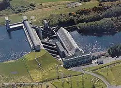 |
| X X | ||||||
| Baal's Bridge[27][28] | 1830 - 1831[27] | 52.6663°N 8.6202°W | - | Limerick | Carries Mary Street from George's Quay on King's Island to Charlotte's Quay on the south side of Limerick city. Replaced (old) Baal's Bridge, erected in c. 16th century, demolished in 1829, and bridges have stood here since at least the 12th century.[29][30] | |
| Bishop O'Dwyer Bridge[31] | 1931[31] | 52.6694°N 8.618°W | - | Limerick | Carries Athlunkard Street from Sir Harry's Mall to the Grove Island Roundabout. Named in honour of Edward O'Dwyer, Bishop of Limerick.[31] Replaced Park Bridge built in 1835.[31] | |
| Abbey Bridge[32] | 1999[32] | 52.6666°N 8.6193°W | - | Limerick | Carries Island Road from King's Island to the Milk Market. Named in honour of generations of the fishermen of the river Abbey, after a proposal to name it after Jim Kemmy was rejected.[32] | |
| Mathew Bridge[33] | 1844 - 1846[33] | 52.6669°N 8.6237°W | - | Limerick | Carries Bridge Street (R463) from King's Island to Rutland Street on the south side of Limerick city. | .jpg.webp) |
| Sylvester O'Halloran Bridge[34] | 1987[34] | 52.6653°N 8.6238°W | - | Limerick | Pedestrian Bridge from the Potato Market, King's Island to behind the Hunt Museum on the south side of Limerick city. |  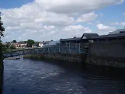 |
| X X | ||||||
| Sarsfield Bridge[35] | 1835[35] | 52.6654°N 8.6303°W | - | Limerick | Swing bridge (non-functioning).[35] Originally known as the Wellesley Bridge.[35] Carries the R857 Ennis Road. The Shannon Rowing Club Boat house was based on an island under the bridge until it was damaged by Storm Darwin[35] | .jpg.webp)  |
| Thomond Bridge | 52.670304°N 8.627174°W | - | Limerick | Links Castle Street on King's Island to High Road on the Northwest bank | 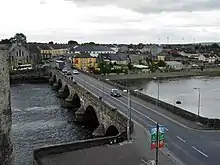 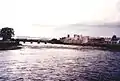 | |
| Shannon Bridge | 1986 | 52.6623°N 8.6351°W | - | Limerick | R527, last bridge in the city and over the Shannon | .jpg.webp) (Shannon Bridge as seen from Sarsfield Bridge) (Shannon Bridge as seen from Sarsfield Bridge) |
| Limerick Tunnel[36] | 2010 | 52.6552°N 8.6868°W | - | Limerick | Carries the N18, Western part of the Limerick Southern Ring Road.[36] | .jpg.webp) |
| Shannon Ferry | 1969[37] | 52.6147°N 9.3804°W | - | Killimer, County Clare - Tarbert Island, County Kerry | Ro-ro ferry. Part of the N67 | 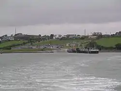 |
| Greenway Bridge Athlone [lower-alpha 1] | 2018 onwards[18][38][39] In spring 2019 the tendering was projected to be completed by 2020.[40] | 53.423971°N 7.942938°W[18] | - | Luan Gallery, Athlone | Cycle/Pedestrian Bridge. Will carry the Dublin-Galway Greenway from the Radisson Hotel to the Luan Gallery.[18][41] | |
| Killaloe Bypass bridge [lower-alpha 2] | Late 2017 onwards[42][43] €8M funding reserved for the project by the Transport Department.[44] Planning still in progress early 2019 with a completion date anticipated of August 2019.[45] | - | Killaloe, Co. Clare | Bypass bridge approximately 1km south of Killaloe, off the R494.[46][47] | ||
| Pedestrian Bridge/walkway Limerick [lower-alpha 3] | 2018 onwards[48][49] | - | Potato Market, Limerick City | Pedestrian Walkway or Bridge (under discussion)[48][49] | ||
| Meelick weir pedestrian bridge [lower-alpha 4] | 2019-2020[50] | 53.174902°N 8.075972°W[50] | - | Meelick Weir, Galway/Offaly border | Cycle/Pedestrian Bridge. Will carry the Beara-Breifne Way near Victoria Lock over the existing Weir to an island on the river.[50] At 300m, it will be the longest pedestrian bridge on the island.[50] Construction, by Waterways Ireland, began in March 2019.[50] | .jpg.webp) (the bridge will rest on this weir) (the bridge will rest on this weir) |
References
Citations
- "NB The Puzzler Blog". 6 January 2013. Archived from the original on 22 August 2014. Retrieved 20 August 2014.
- Biege, Bernd. "The Mighty Shannon's Humble Origins". About.com. Archived from the original on 12 April 2016. Retrieved 12 April 2016.
- "The Shannon Pot". Castlebar.ie. 15 September 2014. Archived from the original on 12 April 2016.
- ManorHamilton.ie|Dowra
- "Roscommon County Council Planning Applications" (PDF). Roscommon County Council. 9 February 2009. Archived from the original (PDF) on 26 August 2014. Retrieved 29 December 2017.
- Shaw, Brian (12 August 2008). "Hartley Bridge". geograph.org.uk. Archived from the original on 18 July 2013. Retrieved 31 January 2018.
- Chadwick, P L. "Carrick Bridge, Carrick-on-Shannon, Co. Leitrim". geograph.org.uk. Archived from the original on 3 April 2016. Retrieved 31 January 2018.
- "Lough Tap railway bridge". IrishWaterwaysHistory.com. 18 October 2010. Archived from the original on 28 September 2013. Retrieved 8 March 2016.
- "Shannon rail bridge nears completion". The Irish Times. 27 October 2009.
- http://www.buildingsofireland.ie/niah/search.jsp?type=record&county=LE®no=30815007
- "1916 Plaque Being Unveiled In Athlone". Midlands103.com. Midlands 103. 9 June 2017. Archived from the original on 2 July 2017. Retrieved 2 July 2017.
- "Bypass bridge to be renamed Cumann na mBan Bridge". Athlone Advertiser. 2 April 2015. Retrieved 2 April 2015.
- English, Eoin (2 March 2017). "Refusal to rename road 'disrespectful' to women of Irish revolution, says Cork councillor". Irish Examiner.
- Councillor Frankie Keena (6 February 2017). Minutes of the Athlone Municipal District Meeting which was held in the Civic Centre, Church Street, Athlone at 3.00 p.m. on Monday, February 6th 2017 (PDF) (Report). Westmeath County Council.
In order to expedite the erection of the Cumann Na mBan nameplate on the Athlone Relief road bridge can this Municipal District in conjunction with Roscommon County Council arrange as soon as possible the appropriate ceremony under the bridge?
- "White Bridge improvements welcome - O'Rourke". Westmeath Independent. 19 November 2015. Archived from the original on 11 December 2015. Retrieved 11 December 2015.
- Kelly, Tom (6 July 2011). "Protester's Athlone railway bridge demonstration is criticised". Westmeath Independent. Archived from the original on 19 November 2015. Retrieved 19 November 2015.
- Coghlan, Finian (2 August 2013). "White Bridge boat crash driver gets trial date". Athlone Advertiser. Archived from the original on 6 August 2013.
- Daly, Maria (9 October 2014). "Council confirm plans for new towncentre bridge as part of cycleway". Athlone Advertiser. Retrieved 9 October 2014.
- "Shannonbridge". Offaly.ie. Offaly County Council. 2007. Archived from the original (.doc) on 26 November 2007. Retrieved 17 September 2019 – via Wayback Machine.
- "Killaloe Bridge, Cullenagh (shanrahan Pr), Tipperary North". National Inventory of Architectural Heritage. Retrieved 26 January 2020.
- http://www.buildingsofireland.ie/niah/search.jsp?type=record&county=LC®no=21900107
- History, O' Brien's Bridge Live.
- "The black bridge". IrishWaterwaysHistory.com. Archived from the original on 29 May 2019. Retrieved 17 September 2019.
- Doherty, Tony (19 July 2017). "Walk for the Weekend: Looping the loop in the lowlands".
- "Man drowns after getting into difficulty while swimming in Shannon". RTÉ.ie. 30 June 2018. Archived from the original on 1 July 2018. Retrieved 15 July 2018.
- http://www.buildingsofireland.ie/niah/search.jsp?type=record&county=LI®no=21502002
- "Baal's Bridge, Mary Street, Broad Street, Limerick, Limerick City". buildingsofireland.ie. Retrieved 13 May 2017.
- "Riots in Limerick - Scarcity of Provisions". London Standard. 4 June 1840. p. 2. Retrieved 9 June 2017 – via NewspaperArchive.

- O'Connell, Daniel (21 April 1829). "Extract of a letter from Mr. O'Connell". Morning Post. p. 3 – via NewspaperArchive.
- "16th C. – Old Baal's Bridge, Limerick". archiseek.com. Retrieved 9 June 2017.
- "Bishop O'Dwyer Bridge – Connection to Clare". limerickslife.com. Archived from the original on 13 June 2015. Retrieved 1 March 2018.
- Slater, Sharon (18 October 2009). "Abbey Bridge - The Newest Bridge in Limerick". limerickslife.com. Archived from the original on 13 June 2015. Retrieved 1 March 2018.
- "Mathew Bridge, Rutland Street, Limerick". buildingsofireland.ie. Retrieved 13 May 2017.
- Slater, Sharon (18 December 2009). "Sylvester O'Halloran Foot Bridge". Retrieved 13 May 2017.
- Slater, Sharon (18 May 2010). "Sarsfield Bridge – Supporting Boatclubs". Archived from the original on 13 June 2015. Retrieved 1 March 2018.
- "Frequently Asked Questions". Limerick Tunnel. 2010. Archived from the original on 29 July 2010.
- https://www.irishtimes.com/business/sectors/transport-and-tourism/shannon-ferry-group-goes-into-the-red-1.531910
- Grace, Robert (10 December 2015). "Councillors welcome latest proposed design for Athlone's cycleway bridge". Athlone Advertiser. Archived from the original on 11 December 2015.
- Fagan, Ronan (30 August 2018). "Greenway extension progress boost as funding is announced". Athlone Advertiser. Archived from the original on 30 August 2018. Retrieved 30 August 2018.
- Cusack, Adrian (24 January 2019). "No train service in Athlone over Easter weekend". Westmeath Independent. Archived from the original on 25 January 2019. Retrieved 9 April 2019.
- "Controversial Athlone bridge gets green light". RTÉ.ie. 8 November 2017. Archived from the original on 8 November 2017. Retrieved 9 January 2018.
- Carolan, Mary (24 June 2016). "High Court hearing on Killaloe bypass". Clare Champion.
- "Full Steam Ahead For Killaloe Bypass". Clare FM. 9 January 2018. Archived from the original on 9 January 2018. Retrieved 9 January 2018.
- Monthly Management Report (pdf) (Report). Clare County Council. 14 February 2019. Archived (PDF) from the original on 9 April 2019. Retrieved 9 April 2019.
- Management Report to Council (pdf) (Report). Tipperary County Council. 15 January 2019. p. 6. Archived (PDF) from the original on 9 April 2019. Retrieved 9 April 2019.
- "Land acquisition 'ongoing' for Killaloe bridge & bypass". Clare Echo. 8 July 2018. Archived from the original on 9 April 2019. Retrieved 9 April 2019.
- "Government spending on roads not enough to prevent decay". Irish Times. 24 January 2017. Retrieved 13 May 2017.
- Sheridan, Anne (22 March 2016). "Councillors blast €18m Limerick project as a 'bridge too far'". Retrieved 21 May 2017.
- Murray, Hugh (1 July 2016). "Limerick needs and deserves a better proposal than footbridge". Retrieved 21 May 2017.
- Mullooly, Ciaran (1 March 2019). "Work to begin on new pedestrian bridge across River Shannon". Archived from the original on 1 March 2019. Retrieved 30 May 2019.
Sources
- "History". O'Brien's Bridge Live. Archived from the original on 9 August 2011. Retrieved 9 June 2017 – via Wayback Machine.
This article is issued from Wikipedia. The text is licensed under Creative Commons - Attribution - Sharealike. Additional terms may apply for the media files.