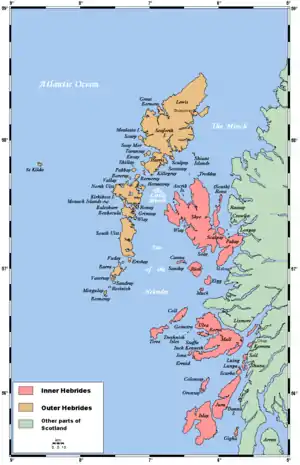
Lismore, Scotland
Lismore (Scottish Gaelic: Lios Mòr, pronounced [ʎis̪ ˈmoːɾ] possibly meaning "great enclosure", or "garden") is an island of some 2,351 hectares (9.1 square miles) in the Inner Hebrides of Scotland. The climate is damp and mild, with over 166 centimetres (65 in) of rain recorded annually. This fertile, low-lying island was once a major centre of Celtic Christianity, with a 6th-century monastery associated with Saint Moluag, and later became the seat of the medieval Bishop of Argyll. There are numerous ruined structures including a broch and two 13th-century castles.
| Scottish Gaelic name | |
|---|---|
| Meaning of name | great garden or great enclosure |
| Location | |
 Lismore Lismore shown within Argyll and Bute | |
| OS grid reference | NM840408 |
| Coordinates | 56.52°N 5.5°W |
| Physical geography | |
| Island group | Mull |
| Area | 2,351 ha (5,810 acres) |
| Area rank | 33 [1] |
| Highest elevation | Barr Mòr, 127 m (417 ft) |
| Administration | |
| Sovereign state | United Kingdom |
| Country | Scotland |
| Council area | Argyll and Bute |
| Demographics | |
| Population | 192[2] |
| Population rank | 34 [1] |
| Population density | 8.2/km2 (21/sq mi)[2][3] |
| Largest settlement | Achnacroish |
| References | [3][4] |
During the 19th century various new industries were introduced, including lime quarrying. During the early decades of the 20th century the population exceeded 1,000; but this was followed by a lengthy decline. Although resident numbers are now less than 200, there was a small increase from 2001 to 2011. About a third of the population were recorded as Gaelic-speaking at the former date. The modern economy is largely based on farming, fishing and tourism and the largest settlement is Achnacroish. Various shipwrecks have been recorded in the vicinity.
Etymology
In the Gaelic name, lios means "garden"[5] or "enclosure",[3] and mòr is simply "big" or "great",[5] reflecting either the fertility of the island amidst mountainous surroundings, or the presence of a defined area surrounding the early monastery.[6] One of the earliest English language references is to "Lismoir", recorded in the 16th century.[7]
Achnacroish is from Achadh na Croise and means "the field of the cross".[8] The other small settlements are Clachan (village with a church)[9] and Port Ramsay opposite Eilean Ramsay (Ramsay's isle). Most of the surrounding islets have descriptive names such as Eilean Dubh (black island), Eilean nan Gamhna (isle of the stirks) and Pladda (flat island, from Old Norse).[10][11]
Geology
Lismore is formed almost wholly from rocks of the Neoproterozoic age Lismore Limestone Formation which is ascribed to the Blair Atholl Subgroup of the Appin Group within the Dalradian sequence. There are also some minor graphitic pelites (sometimes described as 'interbedded black slate',[12][13]within the formation. The limestone country rock is intruded by a handful of NE-SW aligned lamprophyre dykes of Silurian to early Devonian age associated with the Strontian Granite Complex and by large numbers of NW-SE aligned dykes of dolerite and basalt of Palaeogene age along with a rather fewer number assigned to the ‘Loch Scridain Suite.
Quaternary deposits include glacial till and peat alongside some small patches of alluvium (clay, silt, sand and gravel) which occupy lower ground. Around the margins of Lismore are modern beach deposits and raised marine deposits of clay, silt and sand, the latter being a product of varying relative sea-levels during the Holocene epoch. The whole of Scotland was subjected to glaciation during the Pleistocene epoch. A sign of this on Lismore is the presence of rock-cut platforms close to the seashore that indicate the changing sea-levels; in some areas of the northern coast they also betray the presence of ice by the striation marks on the rocks.[14][15][16]
Geography
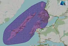
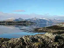
The island of Lismore lies in Loch Linnhe, north east of Mull, in the Argyll and Bute council area. It is 15 kilometres (9.3 mi) long and about 2 kilometres (1.2 mi) wide, and oriented from SW to NE, roughly parallel to the Great Glen Fault. To the east is an arm of Loch Linnhe known as the Lynn of Lorn.[4] Composed almost entirely of limestone, Lismore has fertile soil and an abundance of trees and shrubs including ash and sycamore. The topography consists of sheltered furrows of land between raised areas that run longitudinally up the island's spine.[6][17][18]
The area of the island is 2,351 hectares (9.1 square miles)[3] and the highest elevation is Barr Mòr in the south above Kilcheran, which reaches only 127 metres (417 feet).[4] (Haswell-Smith ranks Lismore as the 50th offshore Scottish island by height).[19]
There are several small lochs on the island, the largest of which are Loch Fiart in the southwest, Kilcheran Loch 3 kilometres (1.9 mi) further northeast, and Loch Baile a' Ghobhainn another 4 km (2.5 mi) northeast, north of Achnacroish.[4] These three water bodies form the Lismore Lochs Special Area of Conservation, a status which is accorded as they are amongst the best examples in Scotland of lochs on a limestone substrate. The alkaline waters are very clear and low in nutrients and support the rare Chara stoneworts C. rudis and C. curtis. C. pedunculata has also been recorded.[20] The lochs lie longitudinally down the island and are of roughly similar size. The total surface area of all three combined is about 32 hectares (79 acres) and they are inhabited by trout.[21][Note 1]
Lismore is part of the ancient district of Lorne and is said to lie "in the cockpit" of this territory.[23] In the modern day it is at the heart of the Lynn of Lorn National Scenic Area, one of forty such areas in Scotland, which have been defined so as to identify areas of exceptional scenery and to ensure its protection from inappropriate development.[24] The national scenic areas cover 15,726 ha, of which 10,088 ha are marine seascape,[25] and includes the whole of Lismore, along with neighbouring areas on the mainland such as Benderloch and Port Appin, and the Shuna Island.[26]
The views from Barr Mòr, the island's highest point, are superlative. Although only of modest size, from there "the skyscape is vast and made so not by its emptiness, but by the throng of high and pointed hills lifting out of the glittering seas and islands. Nowhere else on the Highland coast can you enjoy a view of the mountainous mainland to equal this one."[27]
The offshore islets of Eilean na Cloich and Eilean Dubh in the Lynn of Lorn and Bernera and Dubh Sgeir in the Lynn of Morvern to the west and Eilean Gainimh to the NE, are extensively used by common seals and form the Eileanan agus Sgeirean Lios mòr Special Area of Conservation.[28] The whole island of Bernera is also a SSSI, its limestone maritime cliffs being a key feature along with the presence of the nationally scarce rock whitebeam.[29] Creag Island and Pladda are other islets in the Lynn of Lorn. Eilean nan Caorach, Inn Island, Eilean Droineach and Eilean Ramsay are amongst another cluster of small islands off the north coast, and Eilean Loch Oscair is to the NW.[4] Lismore Lighthouse, built by Robert Stevenson, lies on the small island of Eilean Musdile to the south west, with Lady's Rock a kilometre further away in the same direction.
Climate
Lismore has a maritime climate with cool summers and mild winters. The nearest official Met Office weather station for which online records are available is Dunstaffnage on the mainland north of Oban.
| Climate data for Dunstaffnage 3m asl, 1971-2000 (Weather station 2.7 kilometres (2 mi) NNE of Oban) | |||||||||||||
|---|---|---|---|---|---|---|---|---|---|---|---|---|---|
| Month | Jan | Feb | Mar | Apr | May | Jun | Jul | Aug | Sep | Oct | Nov | Dec | Year |
| Record high °C (°F) | 13 (55) |
13 (55) |
15 (59) |
24 (75) |
25 (77) |
27 (81) |
27 (81) |
27 (81) |
24 (75) |
20 (68) |
15 (59) |
13 (55) |
27 (81) |
| Average high °C (°F) | 7.0 (44.6) |
7.2 (45.0) |
8.6 (47.5) |
11.0 (51.8) |
14.5 (58.1) |
16.2 (61.2) |
17.7 (63.9) |
17.7 (63.9) |
15.4 (59.7) |
12.6 (54.7) |
9.4 (48.9) |
7.9 (46.2) |
12.1 (53.8) |
| Average low °C (°F) | 2.1 (35.8) |
2.2 (36.0) |
3.0 (37.4) |
4.2 (39.6) |
6.6 (43.9) |
8.8 (47.8) |
10.9 (51.6) |
10.9 (51.6) |
9.3 (48.7) |
7.3 (45.1) |
4.3 (39.7) |
3.0 (37.4) |
6.1 (43.0) |
| Record low °C (°F) | −8 (18) |
−7 (19) |
−7 (19) |
−2 (28) |
0 (32) |
2 (36) |
5 (41) |
3 (37) |
1 (34) |
−1 (30) |
−6 (21) |
−8 (18) |
−8 (18) |
| Average precipitation mm (inches) | 192.2 (7.57) |
139.5 (5.49) |
153.2 (6.03) |
80.1 (3.15) |
67.0 (2.64) |
82.6 (3.25) |
102.4 (4.03) |
119.2 (4.69) |
163.3 (6.43) |
186.9 (7.36) |
182.1 (7.17) |
192.4 (7.57) |
1,660.9 (65.39) |
| Average precipitation days (≥ mm) | 27 | 23 | 28 | 24 | 23 | 26 | 24 | 26 | 27 | 28 | 27 | 27 | 310 |
| Average rainy days (≥ mm) | 25 | 21 | 27 | 24 | 23 | 26 | 24 | 26 | 27 | 28 | 27 | 27 | 305 |
| Average snowy days (≥ cm) | 7 | 6 | 5 | 1 | 0 | 0 | 0 | 0 | 0 | 0 | 1 | 3 | 23 |
| Mean monthly sunshine hours | 33.5 | 59.6 | 86.2 | 145.8 | 189.7 | 174.9 | 142.6 | 141.7 | 97.5 | 75.6 | 46.2 | 30.7 | 1,224 |
| Source 1: Met Office [30] | |||||||||||||
| Source 2: Weatherbase [31] | |||||||||||||
Prehistory
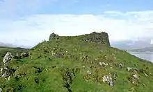
There are various Bronze Age cairns on the island.[32] Tirefour Castle is an Iron Age broch of an uncertain date that is a prominent landmark on Lismore's east coast. The walls have an average thickness of 4.5 metres (15 ft), enclosing a circular court about 12.2 metres (40 ft) in diameter. The wall still stands 3 metres (9.8 ft) high and reaches 4.9 metres (16 ft) in the south east.[33] There is a second possible broch site at An Dùn, SW of Loch Fiart[4] and these are amongst the most southerly examples of these enigmatic fortifications.[34] There are also various duns on the island that may date to the 1st or 2nd centuries AD.[34]
History
Early Christianity and Scandinavian influence
Lismore was an important centre of Celtic Christianity from an early date. The Iona Chronicle records the death of Mo-Luóc (also known as Moluag), who was probably abbot of the Lismore monastery in 594, and of his successors Neman in 613 and Eochaid in 637. There is, however, no reason to suppose that this was a daughter house of Columba's abbey on Iona itself.[35] Lismore probably maintained its status as the principal religious house of the Cenél Loairn during the remainder of the 7th century[36] and the deaths of abbots Iarnlaigh c. 700, Colmán in 704 and Crónán ua Eoain in 718 are recorded in the Annals of Ulster. Five further such obituaries are recorded in the latter half of the 8th century.[37]
Lismore was part of the kingdom of Dalriada in the 6th century and probably thereafter until the arrival of the Vikings in the late 8th century, after which it is likely the island was absorbed into the Norse-Gael Kingdom of the Isles. Magnus Barelegs had established direct Norwegian overlordship over this sprawling sea kingdom by 1098.[38] In that year, Edgar of Scotland signed a treaty with Magnus which settled much of the boundary between the Scots and Norwegian claims in these islands. Edgar formally acknowledged the existing situation by giving up his claims to the Hebrides but there were a few exceptions including Luing and Lismore, which were retained by the Scots.[39]
Medieval period
Lismore later became the seat of the medieval Bishopric of Argyll. Before the late 12th century the Bishopric of Dunkeld included all of Argyll, but sometime between 1183 and 1193 they were separated, as apparently the then Bishop John Scotus was unable to speak Gaelic.[40][41] Lismore became the seat of the new bishop, and he and his successors were known as Episcopi Lismorenses[3] but a papal mandate in 1249 proposed that the see be transferred to "some more secure and accessible place".[42] In the event St Moluag's cathedral at Clachan maintained its position until 1507, when the diocese's centre was moved to Saddell in Kintyre.[3] It was burned down during the Reformation[41] and only the choir survives in greatly altered form, the nave and western tower having been reduced to their foundations. There is also evidence of an enclosure, probably medieval.[43]
The ruins of Coeffin Castle stand on the summit of a rocky promontory on the coast west of Clachan. There is the outline of an oblong hall-house, which may be 13th century, and an irregularly shaped bailey, likely of a later date.[44] A tidal fish trap, of unknown age, is located in the small bay to the south-east of the castle.[45] To the north-east of the castle are the remains of a stone-walled fort.[46]

The remains of Achanduin Castle west of Achnacroish is also thought to date back to the 13th century.[47] Built by the MacDougalls around 1290, who held it throughout the 14th century,[48] the castle is then thought to have been held by the Bishops of Argyll until the mid 16th century.[47][49] The castle overlooks the island of Bernera.[4]
In the 16th century Donald Monro provided a brief description of the island in Scots: Lismoir, ane iyle quher leid ure is, fornent Douard. This iyle is four myle lang, with ane paroche kirke in it.[7] ("Lismore, an isle where lead ore is, opposite Duart. This isle is four miles long, with a parish church on it".)[Note 2] Monro's Description of the Western Isles of Scotland also mentions Eilean Droineach and Eilean Ramsay. He stated that both were "good for corn and store" and had many "Elders and thorns" and that Eilean Droineach was the "habitation of Bishops and Nobles in auld times".[51] However, the view of Munro (1961) is that this last comment more properly applies to the larger "Ramsay Isle".[52]
Lismore is the home of the Clan MacLea, who claim kinship with the Livingstone family, and who were recognised by the Lord Lyon in 2002.[53] The Plod nam Baran, which is adjacent to the site of Saint Moluag's church, may be the burial ground of its clan chiefs, or "barons".[54] The current chief, Niall Livingstone of Bachuil, is the "Coarb of Saint Moluag" and since the 16th century or earlier, the chiefs have been hereditary keepers of the saint's crozier or pastoral staff known as the Bachuil Mòr.[55][56]
18th to 20th centuries
In 1707, the Acts of Union merged England and Scotland, and Lismore became part of the United Kingdom of Great Britain. Thereafter taxes on whisky distillation rose dramatically, and much of Scotland's distillation was either shut down or forced underground until the 1823 Excise Act provided a legal framework for the industry.[57] The remains of at least two illicit stills from this period have been found on Lismore.[58]
In 1749 the ruins of the old cathedral were trimmed down from their remaining height, given a roof and turned into a parish church with a bell tower.[41]
In the 19th century lime was quarried, particularly on the west coast.[17] The ruined remains of the quarriers' cottages can still be seen on Eilean nan Caorach and Inn Island,[17] and old lime kilns can be seen at Sailean, Port na Moralachd and Port Ramsay; the last lime was produced in 1934.[59] The remains of another two kilns can be seen at Kilcheran near Lismore Seminary, a Roman Catholic divinity school that was in operation from 1803 to 1828 at a time when the other inhabitants of the island were staunchly Presbyterian.[60][61]
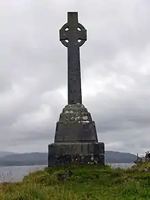
John Stuart McCaig, the architect of McCaig's Tower in Oban, was born on Lismore in the 19th century[62] as was the folklorist Alexander Carmichael.[63] Overlooking Lismore Bay is a Celtic Cross, a memorial to Waverley Arthur Cameron, the son of Duncan Cameron, inventor of the "Waverley" nib pen and the owner of The Oban Times newspaper.[64] Waverley was drowned in 1891 when his yacht foundered off the coast nearby.[64]
There have been various other shipwrecks in the vicinity. In 1889 the paddle steamer Mountaineer lived up to its name by clambering onto Lady's Rock, the damage to which was still visible in 1995. In 1905 the MacBrayne steamship Clydesdale hit the same obstruction in a Force 6 wind. The harbour patrol craft Appletree was sunk in a collision with an RAF pinnace east of the Lismore light in October 1940 with, according to one report, the loss of two lives. The trawler MFV Solway Firth foundered south of this position in 1977.[65]
Lismore, like other Hebridean islands, has suffered from depopulation since the 19th century, in large part due to the Clearances.[66] In 1798 there were 900 people living on the island and 1399 by 1841. Over the next 40 years the population more than halved to 621. By 1961 there were only 155 residents, and by the time of the 1991 census there were just 140.[3] There are various examples of abandoned townships, such as Coille nam Bard.[67] In the 2001 census, the population had risen slightly to 146, over 45% of whom were over 60 years old, making it the Scottish island with the oldest population.[68]
Present day
The island's population was recorded as 192 at the 2011 census,[2] an increase of over 30% since 2001.[69] During the same period Scottish island populations as a whole grew by 4% to 103,702.[70] The majority of the resident working population are engaged in farming or fishing,[17][71] and sheep raised on the island have a reputation for quality.[72] Most of the land is owned by the Duke of Argyll, with the farmers being tenants.[3]
Prior to 2007 there was no mains supply of drinking water on the island, water being supplied instead from wells and springs.[6] In that year the then Scottish Executive announced plans for a mains supply to be provided at a cost of £1 million: a pipe was laid under Loch Linnhe and work was to begin on laying about 10 kilometres (6 mi) of pipes across Lismore.[73] However, Scottish Water later decided to supply water from boreholes instead.[74]
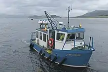
The island is linked to the mainland by two ferries: a Caledonian MacBrayne vehicle ferry making the crossing to Oban and a council passenger ferry making the shorter crossing from Point, at the north-eastern tip of the island, to Port Appin. The B8045 is the main road on the island, which it traverses from beyond Kilcheran in the SW, to Point in the NE.[4]
There are various tourist facilities on Lismore, including a cafe and a post office. Bicycles may be hired at Point. Explore Lismore provide Land Rover Tours and the island's only taxi service. There is no petrol filling station.[75] In 2001 29% of the population of the island spoke Gaelic[76] and maintaining this heritage is one of the aims of the Comann Eachdraidh Lios Mòr, the Lismore Gaelic Heritage Centre.[77]
Lismore is part of the multi-member ward of Oban, Lorn and the Isles in the Argyll and Bute council area.[78] The island is represented by Mike Russell of the SNP at the Holyrood Parliament in Edinburgh who was elected for the Argyll and Bute constituency in 2011, and by Brendan O'Hara of the SNP at the Westminster parliament in London.
Myths and culture
"The Piper's Cave" is a local story about a piper and his dog. According to Alexander Carmichael, the piper entered the Uamh-Chraidh (the "cave of pain") and intended to exit through the Uamh-an-duine (the "cave of the man"). The sounds of his bagpipes could be heard throughout the island. When the piping ceased the dog emerged sightless and hairless but the piper was presumed to have drowned in one of the cave's impassable pools and was never seen again. His lament is recorded as:[79]
- Mis air airin baidh 'us burrail I was drowning and howling
- Measg nan glumag eagalaich Amongst the horrid pools
Another story has St Moluag and St Mulhac conducting a boat race across the Lynn of Lorn with the first to land on Lismore having the right to found a monastery there. Realising that he was going to lose, Moluag cut off his finger and threw it ashore north of the broch of Tirefour, enabling him to claim victory.[62]
The Book of the Dean of Lismore was compiled by the titular dean, James MacGregor, in the 15th century. Held in the National Library of Scotland, it is "one of the greatest treasures" of early Gaelic writing. However it was written in Fortingall, Perthshire and its connection with Lismore itself, if any, is uncertain.[80][Note 3]
See also
References
- Notes
- Loch Baile a' Ghobhainn is 13.3 hectares (33 acres) in extent with an average depth of 11.9 metres (39 ft) and 26.8 metres (88 ft) deep at its maximum. Kilcheran Loch is 11.3 hectares (28 acres) in area and 18.2 metres (60 ft) deep and the figures for Loch Fiart are 13.3 hectares (33 acres) and 17.7 metres (58 ft) respectively.[22]
- Monro's work was first published in Latin in 1582. It forms 11 short "chapters" of George Buchanan's Rerum Scoticarum Historia with all of the islands listed, although with much omission of the details. In this version the description is: "Lismore, eight miles long and two broad, which was formerly the seat of the bishop of Argyle, and in which besides the productions common to others, metals have been found".[50]
- Haswell-Smith states that the manuscript was compiled on Lismore[3] although it is clear that the National Library, where the book is displayed, believe it was written in Perthshire.[80]
- Footnotes
- Area and population ranks: there are c. 300 islands over 20 ha in extent and 93 permanently inhabited islands were listed in the 2011 census.
- National Records of Scotland (15 August 2013). "Appendix 2: Population and households on Scotland's Inhabited Islands" (PDF). Statistical Bulletin: 2011 Census: First Results on Population and Household Estimates for Scotland Release 1C (Part Two) (PDF) (Report). SG/2013/126. Retrieved 14 August 2020.
- Haswell-Smith (2004) p. 109
- Ordnance Survey. OS Maps Online (Map). 1:25,000. Leisure. Retrieved 21 August 2013.
- Mac an Tàilleir (2003) p. 80
- Murray (1977) p. 155
- Monro (1549) "Lismoir" no. 54
- Mac an Tàilleir (2003) p. 3
- Mac an Tàilleir (2003) p. 30
- Mac an Tàilleir (2003) p. 96
- Am Faclair Beag: An English - Scottish Gaelic dictionary incorporating Dwelly Faclair.com. Retrieved 1 December 2012.
- Gray (1974) p. 83
- Stephenson and Merritt (2010) pp. 3, 13
- McCann (1966) pp. 90-91
- "Onshore Geoindex". British Geological Survey. British Geological Survey. Retrieved 6 February 2020.
- "Lismore, sheet 44E (Scotland), Solid Edition". BGS large map images. British Geological Survey. Retrieved 6 February 2020.
- "Lismore". Gazetteer for Scotland. Retrieved 1 August 2013.
- Stephenson and Merritt (2010) p. 13
- Haswell-Smith (2004) p. 504
- "Lismore Lochs". JNCC. Retrieved 3 October 2013.
- "Lismore Lochs - Natura 2000 data form". (pdf) JNCC. Retrieved 3 October 2013.
- Murray and Pullar (1910) "The Lochs of Lismore". Volume II, Part II pp. 171-72. National Library of Scotland. Retrieved 5 October 2013.
- Fraser (2009) p. 106, quoting Aidan MacDonald.
- "National Scenic Areas". NatureScot. Retrieved 30 September 2020.
- "National Scenic Areas - Maps". Scottish Natural Heritage. 20 December 2010. Archived from the original on 12 June 2018. Retrieved 4 May 2018.
- "Lynn of Lorne NSA". NatureScot. Retrieved 30 September 2020.
- Murray (1977) p. 157
- Eileanan agus Sgeiran Lios mór Special Area of Conservation: Advice under Regulation 33(2) (2006) Scottish Natural Heritage.
- "Bernera Island SSSI". www.nature.scot. Retrieved 30 September 2020.
- "Dunstaffnage 1971-2000 averages". Met Office. Archived from the original on 19 October 2011. Retrieved 2 November 2011.
- "Oban weather records". Weatherbase. Retrieved 23 November 2011.
- Hay (2009) Birlinn overview. Birlinn. Retrieved 10 August 2013.
- Historic Environment Scotland. "Lismore, Tirefour Castle (23082)". Canmore. Retrieved 12 August 2012.
- Creegan (1976) p. 65
- Fraser (2009) pp. 105-06
- Fraser (2009) p. 250
- Fraser (2009) p. 372
- Duffy (1992) pp. 110
- Sellar (2000) p. 191
- Turner (1998) p. 646
- Murray (1977) p. 156
- Turner (1998) p. 648
- Macdonald (1974) Abstract. British and Irish Archaeological Bibliography. Retrieved 3 August 2013.
- Historic Environment Scotland. "Lismore:Castle Coeffin (23093)". Canmore. Retrieved 3 August 2013.
- Historic Environment Scotland. "Castle Coeffin, Site Number NM84SE 60 (281488)". Canmore. Retrieved 4 May 2018.
- Historic Environment Scotland. "Castle Coeffin, Site Number NM84SE 15 (23088)". Canmore. Retrieved 1 September 2009.
- "Achadun Castle". Gazetteer for Scotland. Retrieved 15 August 2007.
- Turner (1998) pp. 650-51
- Historic Environment Scotland. "Lismore, Achadun Castle (23018)". Canmore. Retrieved 15 August 2007.
- Munro (1961) p. 54, crediting the translation to "Aikman".
- Munro (1961) p. 55
- Munro (1961) p. 117 indicating the idea was offered by Alexander Carmichael.
- "Warant" Archived 28 September 2007 at the Wayback Machine. Clanmclea.co.uk Retrieved 2 October 2013.
- Carmichael, Alexander (15 April 1909) The Celtic Review pp. 356-375 quoted by "An Gorm Mor - Lismore in Alba". Clanmclea.co.uk Retrieved 2 October 2013.
- "The Official Home of the Clan McLea - the Highland Livingstones". ClanLivingstone.com. Archived from the original on 5 October 2013. Retrieved 16 March 2013.
- "History". Isle of Lismore Community/Lismore Computer Group. Retrieved 5 August 2013.
- "A Brief History History of Scotch Whisky". Whisky.com. Retrieved 4 August 2013.
- Duncan (2006) p. 158
- "Industry" Archived 17 July 2012 at the Wayback Machine. Comann Eachdraidh Lios Mòr. Retrieved 4 August 2013.
- "Limekilns, Stores and Pier, Port Kilcheran, Lismore, Lismore And Appin". British Listed Buildings. Retrieved 4 August 2013.
- MacWilliam, Alexander S. (1958) "The Highland Seminary at Lismore 1803-1828". Blairs College/The Innes Review. Retrieved 4 August 2013.
- Haswell-Smith (2004) p. 111
- "Biography - Alexander Archibald Carmichael". The Carmichael Watson Project. University of Edinburgh. Retrieved 5 August 2013.
- "Walking Highlands". Retrieved 17 February 2013.
Tirefour Broch and Castle Coeffin from Achnacroish
- Baird (1995) pp. 124-26
- Richards (1982) p. 364
- "Tirefour Broch and Castle Coeffin from Achnacroish". Walk Highlands. Retrieved 10 August 2013.
- "Scotland's Island Populations". Scottish Islands Federation. Retrieved 1 November 2008.
- General Register Office for Scotland (28 November 2003) Scotland's Census 2001 – Occasional Paper No 10: Statistics for Inhabited Islands. Retrieved 26 February 2012.
- "Scotland's 2011 census: Island living on the rise". BBC News. Retrieved 18 August 2013.
- "Introduction". Isle of Lismore Community/Lismore Computer Group. Retrieved 4 August 2013.
- Watson (2006) p. 207
- "Mains water flows to isle school". BBC News (26 February 2007). Retrieved 10 August 2013.
- "Lismore Community Council 2008 Information: Minutes of the meeting held at 7pm on Thursday 8th May 2008 at Lismore Public Hall Archived 11 August 2013 at Archive.today". Isle of Lismore Community/Lismore Computer Group. Retrieved 10 August 2013.
- "Local Information". Isle of Lismore Community/Lismore Computer Group. Retrieved 4 August 2013.
- Mac an Tàilleir, Iain (2004) 1901-2001 Gaelic in the Census (PowerPoint ) Linguae Celticae. Retrieved 1 June 2008.
- "A Gaelic Heritage". Comann Eachdraidh Lios Mòr. Retrieved 1 August 2013.
- "Find your councillor - Map of Argyll and Bute". Argyll and Bute Council. Retrieved 2 October 2013.
- Carmichael, Alexander (1908-09) "The Barons of Bachuill". The Celtic Review 5 p. 357
- "Book of the Dean of Lismore". National Library of Scotland. Retrieved 3 August 2013.
- General references
- Baird, Bob (1995) Shipwrecks of the West of Scotland. Glasgow. Nekton Books. ISBN 1897995024
- Cregeen, E. R. (April 1976) "Review of Royal Commission on the Ancient and Historical Monuments of Scotland: Inventory of the Ancient Monuments of Argyll. Vol. II: Lorn". The Scottish Historical Review. Vol. 55 No. 159. JSTOR. Retrieved 3 August 2013.
- Duffy, Seán (1992). "Irishmen and Islesmen in the Kingdom of Dublin and Man 1052–1171". Ériu. 43 (43): 93–133. JSTOR 30007421.
- Duncan, P. J. "The Industries of Argyll: Tradition and Improvement" in Omand, Donald (ed.) (2006) The Argyll Book. Edinburgh. Birlinn. ISBN 1-84158-480-0
- Dwelly, Edward (1911), Faclair Gàidhlig gu Beurla le Dealbhan/The Illustrated [Scottish] Gaelic- English Dictionary (10th ed.), Edinburgh: Birlinn Limited, ISBN 1874744041
- Fraser, James E. (2009). From Caledonia to Pictland: Scotland to 795. The New Edinburgh History of Scotland. 1. Edinburgh: Edinburgh University Press. ISBN 978-0-7486-1232-1.
- Gray, J. M. (March 1974) "The Main Rock Platform of the Firth of Lorn, Western Scotland". Transactions of the Institute of British Geographers. No. 61. JSTOR/The Royal Geographical Society. Retrieved 1 August 2013.
- Haswell-Smith, Hamish (2004). The Scottish Islands. Edinburgh: Canongate. ISBN 978-1-84195-454-7.
- Hay, Robert (2009) Lismore: The Great Garden. Edinburgh. Birlinn. ISBN 9781841585659
- Mac an Tàilleir, Iain (2003) Ainmean-àite/Placenames. (pdf) Pàrlamaid na h-Alba. Retrieved 26 August 2012.
- McCann, S. B. (Oct. 1966) "The Main Post-Glacial Raised Shoreline of Western Scotland from the Firth of Lorne to Loch Broom". Transactions of the Institute of British Geographers. No. 39. JSTOR/The Royal Geographical Society. Retrieved 1 August 2013.
- Macdonald, Aidan (1974) "Two major early monasteries of Scottish Dalriata: Lismore and Eigg". Scottish Archaeological Forum 5 pp. 47–70
- Monro, Sir Donald (1549) Description of the Western Isles of Scotland. William Auld. Edinburgh - 1774 edition.
- Munro, R. W. (1961) Monro's Western Isles of Scotland and Genealogies of the Clans. Edinburgh and London. Oliver and Boyd.
- Murray, Sir John and Pullar, Laurence (1910) Bathymetrical Survey of the Fresh-Water Lochs of Scotland, 1897-1909. London. Challenger Office.
- Murray, W.H. (1977) The Companion Guide to the West Highlands of Scotland. London. Collins.
- Richards, Eric (1982) The History of the Highland Clearances: Agrarian Transformation and the Elections, 1746-1886. Croom Helm. London.
- Sellar, William David Hamilton (2000). "Hebridean sea kings: The successors of Somerled, 1164–1316". In Cowan, Edward J.; McDonald, Russell Andrew (eds.). Alba: Celtic Scotland in the middle ages. Tuckwell Press. ISBN 978-1-86232-151-9.
- Stephenson, David and Merritt, Jon (2010) "Argyll and the Islands". (pdf) Scottish Natural Heritage. Retrieved 1 August 2013.
- Turner, Dennis (1998). "The Bishops of Argyll and the Castle of Achanduin, Lismore, AD 1180-1343" (PDF). Proceedings of the Society of Antiquaries of Scotland. 128: 645–652. Retrieved 3 August 2013.
- Watson, John N. "Agriculture" in Omand, Donald (ed.) (2006) The Argyll Book. Edinburgh. Birlinn. ISBN 1-84158-480-0
External links
| Wikimedia Commons has media related to Lismore. |
| Wikivoyage has a travel guide for Lismore. |
- Am Faclair Beag: An English - Scottish Gaelic dictionary incorporating Dwelly Faclair.com. Retrieved 1 December 2012.
- Isle of Lismore Community Website
- Lismore Landscape Project
- Lismore Historical Society
- Clan MacLea/Livingstone Society
- Walks on the Isle of Lismore
- Extract from The Isle of Lismore by Hector Macpherson
Aug1995.jpg.webp)

