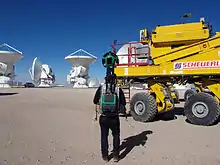
Google Street View in South America
In South America, Google Street View is available in parts of Colombia, Brazil, Peru, Chile, Argentina, Ecuador, Bolivia and Uruguay. This article covers all of South America. For Central America and the Caribbean, see Google Street View in North America.
Background
Brazil
In September 2010, the first cities from Brazil were added.[1] The service started with 51 cities, most from São Paulo, Rio de Janeiro, Belo Horizonte and greater metropolitan areas. Historic cities such as Ouro Preto, Diamantina and Tiradentes were also included. Google is expecting to cover 90% of Brazilian streets in two years.[2]
Google is also working on "Street View" for Brazil's rainforests. Pedal-powered trikes are being used to film the forests, and boats with 3-D cameras are being used to navigate the Amazon River.[3]
In the initial release of Brazil's Street View, two dead bodies were found in the images. These were later removed.[4]
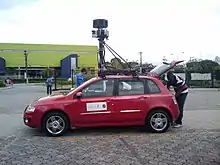
Filming of Street View in Brazil began in April 2009.
Chile
Filming of Street View in Chile began in January 2012. On September 25, 2012, parts of Chile were added including Santiago, Valparaíso, Viña del Mar and Concepción.[6] Many more cities and roads were released during 2013. In March 2015 the country counts with mostly full coverage.
Colombia
On September 3, 2013, parts of Colombia were added. Some cities like Bogotá, Barranquilla, Montería, Cúcuta, Ibagué, Barrancabermeja, Caucasia, Valledupar, Yopal, Aguachica, Soledad, Villavicencio, Manizales, Zipaquirá, Floridablanca, Carmen de Bolívar, Fundación, Cartagena, Bucaramanga, Santa Marta, Santa Rosa de Cabal and more.[7]
Ecuador
Some coverage became available on the Galapagos Islands on September 12, 2013, mostly from a boat. For the mainland Street view was released on November 12, 2015 in Quito, Guayaquil, Cuenca, Santo Domingo (limited), Machala, Durán, Portoviejo, Manta, Loja, Ambato, Esmeraldas, Quevedo, Riobamba, Milagro, Ibarra, La Libertad, Babahoyo, Sangolquí, Daule, Latacunga, Tulcán, Chone, Santa Rosa, Nueva Loja, Huaquillas, Santa Elena, Cayambe, Salinas, General Villamil Playas .[8]
Peru
On August 14, 2013, Google Street View became available for six cities: Lima, Arequipa, Trujillo, Chiclayo, Iquitos[9] and Piura. Later 2013 some long road stretches became available. The highest road in the world which is shown in Street View, is located at 11.598095°S 76.192288°W on 4,818 metres (15,807 ft) altitude.
Argentina
On September 25, 2013, Google announced the arrival of the service to Argentina. On October 2 took place the official presentation of the Trikes in Congressional Plaza, Buenos Aires, the service was expected to be available by the end of the year in Buenos Aires, Buenos Aires Province, Cordoba, Rosario, Santa Fe, Entre Ríos, Mendoza and La Plata.[10] As of September 25, 2014, Argentina was added to Street View.[11]
Bolivia
On November 28, 2014, Google started filming in Santa Cruz de la Sierra but street view will be also available in La Paz, Cochabamba, Sucre and El Alto. For security reasons, Google decided not reveal how many cars will take photos. Additionally, Bolivian media are not allowed to interview their drivers.[12] Images will be appear on street view some time in 2015.
Timeline of introductions
* Limited coverage.
Areas included
Reference:[24]
 Argentina
 Bolivia
| Province | Major cities/areas |
|---|---|
| Padilla, Sucre, Tarabuco, Yotala | |
| Aiquile, Capinota, Cliza, Cochabamba, Irpa Irpa, Mizque, Punata, Quillacollo, Sacaba, Sipe Sipe, Tarata, Tiquipaya | |
| Calamarca, Copacabana, El Alto, Laja, La Paz, Palca, Patacamaya, Tiwanaku, Viacha | |
| Oruro | |
| Villa Imperial de Potosí | |
| Camiri, Cotoca, La Guardia, Mineros, Montero, Portachuelo, Porongo, San José de Chiquitos, Santa Cruz de la Sierra, Santa Rita, Vallegrande, Warnes | |
| Villamontes |
 Brazil
 Chile
Chile
 Colombia
 Ecuador
| Province | Major cities/areas |
|---|---|
| mainland | Quito, Guayaquil, Cuenca, Santo Domingo (limited), Machala, Durán, Portoviejo, Manta, Loja, Ambato, Esmeraldas, Quevedo, Riobamba, Milagro, Ibarra, La Libertad, Babahoyo, Sangolquí, Daule, Latacunga, Tulcán, Chone, Santa Rosa, Nueva Loja, Huaquillas, Santa Elena, Cayambe, Salinas, General Villamil and major roads |
| mostly from a boat |
 Peru
Peru
 United Kingdom
| Regions | Major cities/areas |
|---|---|
| Carcass Island, West Point Island, New Island | |
| Grytviken, Right Whale Bay, Prion Island, Hercules Bay |
 Uruguay
Countries without any coverage
![]() French Guiana,
French Guiana,
![]() Guyana,
Guyana,
![]() Paraguay,
Paraguay,
![]() Suriname,
Suriname,
![]() Venezuela
Venezuela
All these countries have photo spheres, 360-degree panorama photos similar to the street view photos, accessible in Google Maps.
Competing products
- Argentina: Two Argentine street view services have existed. Mapplo[26] was claimed to be the first street view in Latin America.[27] Mapplo closed in 2012. Fotocalle, another Argentine project, is claimed to be the first street view in the world that provides HD pictures.[28] Fotocalle is not working as of November 2020.
- Chile: Chilean company Publiguías released a service similar to Google's Street View in December 2010 called "Street Diving". It offers views of Providencia and Santiago communes, with plans to expand it to other communes in the future.[29] XYGO launched a street view service in April 2011 partially covering seven cities.[30]
References
- "Serviço Google Street View chega ao Brasil | Infosfera". Wp.clicrbs.com.br. September 28, 2010. Retrieved October 2, 2010.
- Gustavo Petró Do G1, em São Paulo. "G1 – Street View estreia na América do Sul com 51 cidades brasileiras – notícias em Tecnologia e Games". G1.globo.com. Retrieved October 2, 2010.
- "Google Street View Cameras Map The Amazon". SkyNewsHD. November 10, 2011. Retrieved May 29, 2012.
- "Google Street View snaps dead bodies in Brazil". The Press NZ. May 10, 2010. Archived from the original on July 14, 2014. Retrieved May 29, 2012.
- "All ESO's Observatories Included in Google Street View". ESO Announcement. Retrieved June 11, 2014.
- "Google Lat Long: Introducing Imagery of Chile and Croatia on Google Maps". Google-latlong.blogspot.co.uk. September 26, 2012. Retrieved January 19, 2013.
- EL TIEMPO – Hoy se Lanza Google Street View en Colombia – http://www.eltiempo.com/tecnologia/internet/ARTICULO-WEB-NEW_NOTA_INTERIOR-13042963.html
- http://www.elcomercio.com/tendencias/ecuador-recorrerse-virtualmente-googlemaps.html
- "Google Street View on Iquitos". Retrieved April 25, 2014.
- "Google Street View llega a la Argentina". lanacion.com.ar. September 25, 2013. Retrieved October 25, 2013.
- "Google Street View available in BA". buenosairesherald.com/. September 26, 2014. Retrieved October 26, 2014.
- "Archived copy". Archived from the original on December 13, 2014. Retrieved December 12, 2014.CS1 maint: archived copy as title (link)
- http://www.elpais.com.uy/informacion/camaras-google-street-view-uruguay.html
- http://www.elpais.com.uy/vida-actual/uruguay-google.html
- "Quatro museus brasileiros estreiam coleções no Google Street View; veja | Notícias". TechTudo. January 13, 2014. Retrieved February 28, 2014.
- "Google Street View". Google.com. Retrieved December 3, 2015.
- "Google Lat Long: Mapping Brazilian islands, above ground and under the sea". Google-latlong.blogspot.ro. March 17, 2015. Retrieved December 3, 2015.
- Jornal do Brasil. "Jornal do Brasil – Ciência e Tecnologia – Cemitério São João Batista é o primeiro da America Latina no Google Street View". Jb.com.br. Retrieved December 3, 2015.
- "Google adds parts of Bolivia and Ecuador to Street View". 9to5Google. November 16, 2015. Retrieved December 3, 2015.
- Guaifai. "Quito, Guayaquil, Cuenca y más ya son parte de Google Street View". El Comercio. Retrieved December 3, 2015.
- "Google Maps". Goo.gl. Retrieved December 3, 2015.
- "Ya se puede recorrer Uruguay en Google Street View | Noticias Uruguay y el Mundo actualizadas – Diario EL PAIS Uruguay". Elpais.com.uy. Retrieved December 3, 2015.
- 06.01 EST (January 1, 1970). "Do Machu Picchu from your sofa, thanks to Google Street View | Travel". The Guardian. Retrieved December 3, 2015.
- https://www.google.com/maps/
- O Diário de Teresópolis. Teresópolis no Google Street View
- "Buenos Aires Street view". Mapplo.com. Archived from the original on August 30, 2010. Retrieved August 27, 2010.
- "Mapplo: Primer street view de latinoamerica". Blogs.lanacion.com.ar. Archived from the original on May 24, 2010. Retrieved August 27, 2010.
- Paulita. "Fotocalle: Un Street View argentino con imágenes panorámicas de 50 megapíxels". Dotpod.com.ar. Retrieved August 27, 2010.
- "Publiguías a lo 'Street View': Inaugura sistema de mapas con imágenes reales – Publimetro". Publimetro.cl. Archived from the original on July 7, 2011. Retrieved December 11, 2010.
- Lanzan en Chile nueva alternativa para ver mapas de ciudades con visión en 360°, EMOL, April 15, 2011.
