Boiry-Notre-Dame
Boiry-Notre-Dame is a commune in the Pas-de-Calais department in the Hauts-de-France region in northern France.
Boiry-Notre-Dame | |
|---|---|
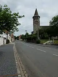 The church of Boiry-Notre-Dame | |
.svg.png.webp) Coat of arms | |
Location of Boiry-Notre-Dame 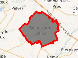
| |
 Boiry-Notre-Dame  Boiry-Notre-Dame | |
| Coordinates: 50°16′25″N 2°56′41″E | |
| Country | France |
| Region | Hauts-de-France |
| Department | Pas-de-Calais |
| Arrondissement | Arras |
| Canton | Brebières |
| Intercommunality | CC Osartis Marquion |
| Government | |
| • Mayor (2008–2014) | Jacques Legris |
| Area 1 | 6.11 km2 (2.36 sq mi) |
| Population (2017-01-01)[1] | 454 |
| • Density | 74/km2 (190/sq mi) |
| Time zone | UTC+01:00 (CET) |
| • Summer (DST) | UTC+02:00 (CEST) |
| INSEE/Postal code | 62145 /62156 |
| Elevation | 43–95 m (141–312 ft) (avg. 82 m or 269 ft) |
| 1 French Land Register data, which excludes lakes, ponds, glaciers > 1 km2 (0.386 sq mi or 247 acres) and river estuaries. | |
Geography
Boiry-Notre-Dame is a farming village located 10 miles (16 km) southeast of Arras on the D34 road.
Population
| Year | Pop. | ±% |
|---|---|---|
| 1962 | 374 | — |
| 1968 | 389 | +4.0% |
| 1975 | 370 | −4.9% |
| 1982 | 408 | +10.3% |
| 1990 | 430 | +5.4% |
| 1999 | 418 | −2.8% |
| 2009 | 455 | +8.9% |
Sights
- The church of St. Vaast, rebuilt after the destruction of the village during World War I.
References
- "Populations légales 2017". INSEE. Retrieved 6 January 2020.
| Wikimedia Commons has media related to Boiry-Notre-Dame. |
| Authority control |
|
|---|
This article is issued from Wikipedia. The text is licensed under Creative Commons - Attribution - Sharealike. Additional terms may apply for the media files.