Abère
Abère is a commune in the Pyrénées-Atlantiques department in the Nouvelle-Aquitaine region in southwestern France.
Abère | |
|---|---|
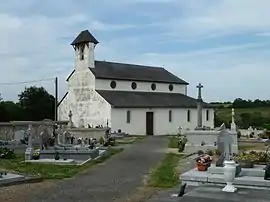
 The church of Abère | |
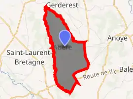
Location of Abère 
| |
 Abère  Abère | |
| Coordinates: 43°23′26″N 0°10′28″W | |
| Country | France |
| Region | Nouvelle-Aquitaine |
| Department | Pyrénées-Atlantiques |
| Arrondissement | Pau |
| Canton | Pays de Morlaàs et du Montanérès |
| Intercommunality | Nord-Est Béarn |
| Government | |
| • Mayor (2020-2026) | Myriam Cuillet |
| Area 1 | 5.81 km2 (2.24 sq mi) |
| Population (2017-01-01)[1] | 162 |
| • Density | 28/km2 (72/sq mi) |
| Demonym(s) | Abérois, Abéroises |
| Time zone | UTC+01:00 (CET) |
| • Summer (DST) | UTC+02:00 (CEST) |
| INSEE/Postal code | 64002 /64160 |
| Elevation | 239–346 m (784–1,135 ft) (avg. 335 m or 1,099 ft) |
| 1 French Land Register data, which excludes lakes, ponds, glaciers > 1 km2 (0.386 sq mi or 247 acres) and river estuaries. | |
Geography


Location
Abère is located some 22 km northeast of Pau and some 9 km northeast of Morlaas. The D7 road (Route de Vic) heading east from Saint-Jammes passes through the southern portion of the commune and continues to Baleix. Access to the village is by the Chemin de Lapoutge going north from the D7 for about 6 km. The Highway D207 coming south from Simacourbe forms the eastern boundary of the commune. The commune is mostly farmland with forests in the north and east[2]
Hydrography
Located in the watershed of the Adour, the Grand Léez river forms the western border of the commune, with the Arriutort joining it at the northern tip of the commune and forming the northeastern border of the commune.
Localities and hamlets
- Bartot
- Berducq
- Bordenave
- Briscoulet
- Courde
- Crouquet
- Hourcade
- Labat
- Larré
- Piarrette
- Salabert
- La Teulère[3]
Neighbouring communes and towns
Toponymy
The name Abère was mentioned in the tenth century[5] (according to Pierre de Marca[6]) and appeared in the forms:
- Oere and Bere (1385[5] Census of Béarn[7]),
- Vere and Avere (1385[8] Census of Morlaàs, but uncertain if it is the same locality[8]),
- Oeyre was mentioned in 1487[5] Registry of Béarnais businesses.[9]
- Abere appears on the Cassini Map of 1750[8][10] and in the 1790 map,[11] Bulletin of Laws.
Michel Grosclaude[8] proposed a Latin etymology of abellana or abella, derived from the Béarnais abera (according to Brigitte Jobbé-Duval.[12]), which means "hazelnut" and by extension "the hazel copse"
The commune's name in Béarnais is Avera.
History
Paul Raymond[5] noted that in 1385, there were 8 fires in Abère and that it depended on the bailiwick of Pau. A barony was created in 1672, a vassal of the Viscounts of Béarn. The commune was part of the Archdiocese of Vic-Bihl, which in turn depended on the Diocese of Lescar of which Lembeye was the capital.[13]
Its Lay Abbey, ![]() [14] the house of Bosom d'Abadie is mentioned in 1385.
[14] the house of Bosom d'Abadie is mentioned in 1385.
Administration
List of Successive Mayors of Abère[15]
| From | To | Name | Party | Position |
|---|---|---|---|---|
| 1995 | 2008 | Jean-Pierre Lortet | ||
| 2008 | 2014 | Claude Conte-Hourticq | ||
| 2014 | Current | Myriam Cuillet |
(Not all data is known)
Intercommunality
Abère is a member of three inter-communal organisations:[16]
- the community of communes of the Pays de Morlaàs
- the AEP Union for the Luy and Gabas Regions
- the energy Union of the Pyrénées-Atlantiques
Population
|
| ||||||||||||||||||||||||||||||||||||||||||||||||||||||||||||||||||||||||||||||||||||||||||||||||||||||||||||||||||
| Source: EHESS[17] and INSEE[18] | |||||||||||||||||||||||||||||||||||||||||||||||||||||||||||||||||||||||||||||||||||||||||||||||||||||||||||||||||||
Politics
Presidential Elections Second Round:[19]
| Election | Winning Candidate | Party | % | |
|---|---|---|---|---|
| 2017 | Emmanuel Macron | EM | 67.02 | |
| 2012 | Nicolas Sarkozy | UMP | 59.38 | |
| 2007 | Nicolas Sarkozy | UMP | 71.57 | |
| 2002 | Jacques Chirac | RPR | 85.86 | |
Culture and Heritage
Civil heritage
Several structures are listed as historical monuments in the commune. These are:
Religious Heritage
- The Church of St. John the Baptist (16th century)
 [24] The church contains several historical objects. These are:
- Processional Cross (17th century)
 [25]
[25] - Altar Cross
 [26]
[26] - Painting: Christ on the Cross with Saint John, the Virgin, and Saint John the Baptist (18th century)
 [27]
[27] - Baptismal Fonts (12th century)
 [28]
[28] - 4 Altar Candlesticks
 [29]
[29] - 2 statues: Angels holding a column and a scale
 [30]
[30] - Tabernacle
 [31]
[31] - Altar (18th century)
 [32]
[32] - Altar, Tabernacle, and 4 Candlesticks at the secondary altar
 [33]
[33]
- Processional Cross (17th century)
See also
References
- "Populations légales 2017". INSEE. Retrieved 6 January 2020.
- Google Maps
- Ministry of Culture, Mérimée IA00027108 Tile Factory (in French)
- Géoportail, IGN, consulted on 14 October 2011 (in French)
- Topographic Dictionary of the Department of Basses-Pyrenees, Paul Raymond, Imprimerie nationale, 1863, Digitised from Lyon Public Library 15 June 2011, p. 2 (in French)
- Pierre de Marca, History of Béarn p. 268 (in French)
- Manuscript of the 14th century - Departmental Archives of Pyrénées-Atlantiques (in French)
- Michel Grosclaude, Toponymic Dictionary of communes, Béarn, Edicions reclams & Édition Cairn - 2006, 416 pages, ISBN 2 35068 005 3, p. 214 (in French)
- Manuscripts of the 15th and 16th centuries - Departmental Archives of Pyrénées-Atlantiques (in French)
- Cassini Map 1750 - Abère
- Cassini Map 1790 - Abère
- Brigitte Jobbé-Duval, Dictionary of place names - Pyrénées-Atlantiques, 2009, Archives and Culture, ISBN 978-2-35077-151-9
- Topographic Dictionary of the Department of Basses-Pyrenees, p. 174
- Ministry of Culture, Mérimée IA00027107 Lay Abbey (in French)
- List of Mayors of France (in French)
- Intercommunalité des Pyrénées-Atlantiques, Cellule informatique préfecture 64, consulted on 9 November 2011
- Données Cassini, EHESS
- Population en historique depuis 1968, INSEE
- http://www.lemonde.fr/data/france/presidentielle-2017/
- Ministry of Culture, Mérimée IA00027106 Town Hall (Presbytery) (in French)
- Ministry of Culture, Mérimée IA00027105 Chateau of Bordenave d'Abère (in French)
- Ministry of Culture, Mérimée IA00027103 Menyucq House (in French)
- Ministry of Culture, Mérimée IA00027102 Houses and Farms (in French)
- Ministry of Culture, Mérimée IA00027104 Church of St. John the Baptist (in French)
- Ministry of Culture, Palissy IA64000446 Processional Cross (in French)
- Ministry of Culture, Palissy IA64000445 Altar Cross (in French)
- Ministry of Culture, Palissy IA64000444 Painting: Christ on the Cross (in French)
- Ministry of Culture, Palissy IA64000443 Baptismal Fonts (in French)
- Ministry of Culture, Palissy IA64000442 4 Altar Candlesticks (in French)
- Ministry of Culture, Palissy IA64000441 2 Statues of angels (in French)
- Ministry of Culture, Palissy IA64000440 Tabernacle (in French)
- Ministry of Culture, Palissy IA64000439 Carved wood Altar (in French)
- Ministry of Culture, Palissy IM64000438 Altar, Tabernacle, 4 Candlesticks (in French)
| Wikimedia Commons has media related to Abère. |