Westerwood
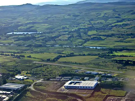
Westerwood is an area in the north-east of Cumbernauld in North Lanarkshire, Scotland. Historically it was the site of a Roman Fort of which a video reconstruction has been produced.[2] In the past two decades, new housing developments have been built around the Westerwood Hotel and Golf Course.[3] The golf course, which was designed by Seve Ballesteros and Dave Thomas, is located on the north side of the town, close to Cumbernauld Airport. Westerwood Community Council was set up for local residents and a committee has been appointed.[4] Neighbouring villages which are outside of Cumbernauld include Dullatur to the north-west and Castlecary to the east.

.jpg.webp)

_(geograph_2081939).jpg.webp)
Roman Heritage


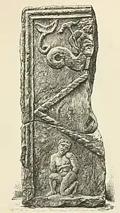
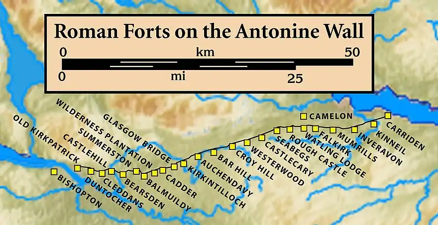
Historically, Westerwood is the site of a Roman Fort on the Antonine Wall.[10] Its neighbouring forts were Croy Hill to the west and Castlecary to the east. At Tollpark,[11] is one of the best preserved continuous sections of the whole Wall, between the forts of Castlecary and Westerwood.[12] There may have been a signal tower at Garnhall[13][14] from where both Westerwood and Castlecary forts are likely to have been visible.[15] A kissing gate behind Castlecary Hotel provides access to this section of the wall to the east.[16] Parking for the section of the wall to the west can be found at Dullatur or Croy.[17] Many Roman forts along the wall held garrisons of around 500 men.[18] Larger forts like Castlecary and Birrens had a nominal cohort of 1000 men[19] but probably sheltered women and children as well[20] although the troops were not allowed to marry.[21] There is also likely to have been large communities of civilians around the site.[22] Westerwood was excavated in 1932 by Sir George Macdonald who wrote about it.[23] It was also excavated in 1974 and 1985-8.[24] Finds near Westerwood include a distance slab depicting a sea-deity and a naked, tied, captive and an uninscribed altar which were found at Arniebog.[25] The slab can now be viewed at the Hunterian Museum in Glasgow. Other artefacts include a diamond patterned stone[26] and a grey, buff jar.[27] A religious stone showed a relief of an engorged phallus over the inscription EX VOTO "the result of a vow".[28] It was found in 1725 but has since been lost. It had a second inscription: NVX "the night".[29] Also a centurion called Verecundus, and his wife, dedicated an altar to Silvanus and the Sky which was recovered at Westerwood.[30][31][32] Pottery found at Westerwood is unlike any other pottery found on the Antonine Wall. It has been suggested that the course pottery was made locally by a single potter at Westerwood.[33]

References
- "OS 25 inch map 1892-1949, with Bing opacity slider". National Library of Scotland. Ordnance Survey. Retrieved 12 October 2017.
- "Reconstruction of fort, Westerwood". Retrieved 19 May 2018.
- Dunsmuir, Alistair (9 October 2017). "UK's largest golf resort operator is sold". The Golf Business. Retrieved 21 October 2017.
- "Time for residents to come together". Cumbernauld News. 17 January 2018. Retrieved 27 January 2018.
- "Distance Slabs". The Antonine Wall. CastlesFortsBattles.co.uk network. Retrieved 27 October 2017.
- Mitchell, Arthur (1881). The past in the present. What is civilization?. New York: Harper & brothers. p. 261. Retrieved 27 October 2017.
- "Fragment of possible Distance Slab, Arniebog, Westerwood". Retrieved 19 May 2018.
- MacDonald, James (1897). Tituli Hunteriani. An account of the Roman stones in the Hunterian Museum, University of Glasgow. Glasgow: T. & R. Annan & Sons. p. 77. Retrieved 2 June 2018.
- "Uninscribed altar, Arniebog, Westerwood". Retrieved 21 October 2017.
- Historic Environment Scotland. "Antonine Wall and fort, railway line to 300m E of Westerwood steading (SM90017)". Retrieved 18 April 2019.
- "OS 25 inch Map 1892-1949". zoomable map with Bing transparency overlay. National Library of Scotland. Retrieved 10 October 2017.
- "Tollpark". Frontiers of the Roman Empire. Retrieved 21 October 2017.
- "Reconstruction model, Temporary Camp, Garnhall". Retrieved 19 May 2018.
- "Garnhall". Frontiers of the Roman Empire. Retrieved 21 October 2017.
- Woolliscroft, David J. (2008). "Excavations at Garnhall on the line of the Antonine Wall" (PDF). Proceedings of the Society of Antiquaries of Scotland. 138: 129–176. Retrieved 30 June 2018.
- "Castlecary to Westerwood". The Antonine Wall. Retrieved 21 October 2017.
- "Westerwood to Bar Hill". The Antonine Wall. Retrieved 21 October 2017.
- "Soldier". Frontiers of the Roman Empire. Retrieved 21 October 2017.
- Miller, S. N. (1952). The Roman Occupation Of South Western Scotland Being Reports Of Excavations And Surveys Carried Out Under The Auspices Of The Glasgow Archaeological Society By John Clarke, J. M. Davidson, Anne S. Robertson, J. K. St. Joseph, Edited For The Society With An Historical Survey By S. N. Miller. Glasgow: Robert Maclehose & Company Limited. Retrieved 11 October 2017.
- "Children". Frontiers of the Roman Empire. Retrieved 21 October 2017.
- "Roman child's leather shoe". A History of the World. BBC. Retrieved 17 October 2017.
- Rohl, Darrell, Jesse. "More than a Roman Monument: A Place-centred Approach to the Long-term History and Archaeology of the Antonine Wall" (PDF). Durham Theses. Durham University. Available at Durham E-Theses Online ref: 9458. Retrieved 14 October 2017.
- Macdonald, Sir George (1934). The Roman wall in Scotland, by Sir George Macdonald (2d ed., rev., enl., and in great part rewritten ed.). Oxford: The Clarendon press. pp. 252–258. Retrieved 11 October 2017.
- "Westerwood, Antonine Wall". Canmore. Retrieved 21 October 2017.
- "distance slab (possible) decorated with triton and kneeling captive". Hunterian Museum. University of Glasgow. Retrieved 12 October 2017.
- "dressed building stone with diamond pattern". Hunterian Museum & Art Gallery Collections: GLAHM F.1981.5. Glasgow University. Retrieved 21 October 2017.
- "jar, grey buff". Hunterian Museum & Art Gallery Collections: GLAHM F.1986.4. Glasgow University. Retrieved 21 October 2017.
- "RIB 2157. Dedication". Roman Inscriptions of Britain. Retrieved 2 June 2018.
- "Westerwood". Roman Britain. Retrieved 21 October 2017.
- "NLC_Altar_To_Flavius_Verecundus_Update". Retrieved 21 October 2017.
- "Westerwood". Frontiers of the Roman Empire. Retrieved 21 October 2017.
- Wright, R. P. A Roman Altar from Westerwood on the Antonine Wall (PDF) (Volume 100, 192-3 ed.). Society of Antiquaries of Scotland. Retrieved 15 February 2018.
- Keppie, L J F (September 2010). "Excavations at the Roman fort of Westerwood on the Antonine Wall, 1985–88". Glasgow Archaeological Journal. 19 (19): 83–100. Retrieved 9 June 2018.
