Duntocher
Duntocher (Scottish Gaelic: Dùn Tòchair or Druim Tòchair) is a village in West Dunbartonshire, Scotland. It has an estimated population of 6,850.[2] The etymology of the name of the village indicates that its name means "the fort on the causeway".[3]
Duntocher
| |
|---|---|
 Main Street, Duntocher | |
 Duntocher Location within West Dunbartonshire | |
| Population | 6,880 (mid-2016 est.)[1] |
| OS grid reference | NS490730 |
| Council area | |
| Lieutenancy area | |
| Country | Scotland |
| Sovereign state | United Kingdom |
| Post town | CLYDEBANK |
| Postcode district | G81 6 |
| Dialling code | 01389 |
| Police | Scotland |
| Fire | Scottish |
| Ambulance | Scottish |
| UK Parliament | |
| Scottish Parliament | |
Duntocher has effectively become a northern suburb of the nearby town of Clydebank, as have neighbouring Hardgate and Faifley. Duntocher expanded due to housebuilding by Clydebank Burgh Council after the Second World War, although the area was never formally absorbed into the burgh. When burghs were abolished by local government reorganisation in 1975, however, Duntocher was included in the larger Clydebank District, which existed until the creation of West Dunbartonshire in 1997. Further housing was built by the Wimpey firm in the late 1960s and early 1970s, on what had been green belt land. Along with Faifley and Hardgate, Duntocher falls within West Dunbartonshire's Kilpatrick ward with a combined population of 12,719 in 2011.[4]
At one time this was the most north westerly point on the Glasgow Corporation Transport tram system, trams operating from here via Hardgate to Clydebank, and at times, on to Partick depot.
Duntocher historically had several cotton and corn mills, driven by the Duntocher Burn which is the traditional boundary between Duntocher and neighbouring village Hardgate.
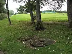
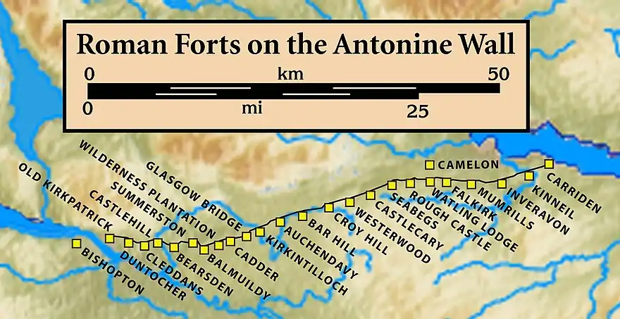
The Antonine Wall also runs through the village, and ancient Roman fortifications are still visible in the local Goldenhill Park.[5] Lottery funding is to provide funds for a children's playpark at Goldenhill.[6] Sir George Macdonald wrote about the findings at Duntocher.[7]
Duntocher has a Roman Catholic church - St. Mary's, a United Free Church of Scotland - Duntocher West, and a Church of Scotland - Duntocher Trinity. The village also has one Roman Catholic primary school - St Mary's and one non-denominational, Carleith Primary School.
The village has a main street (Dumbarton Road) which acts as the main focal point for village activity. The majority of the villages shops and pubs, the cafe and the local churches and village halls are located along or very close to a small stretch of this road
The village is at the southern edge of the Kilpatrick Hills.
History
The Roman Fort at Duntocher has been known about since at least the 18th century.[8] Digital reconstructions of the fort[9][10] and the fortlet it was built to replace, have been created.[11]

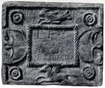
Two distance slabs[19] of the Second Legion were found in the area. Other distance slabs by the Second Legion have been mapped with RTI and include one from Balmuildy.[20] The Second Legion is also associated with The Bridgeness Slab. The slabs are two of the four inscriptions on stone found at Duntocher.[21] The first, with its upper right corner missing, also lacks information about its discovery. Both slabs have a capricorn (half goat, half fish) above and a Pegasus (winged horse) below their inscriptions; these are both emblems of the Second Legion. Both slabs also have two decorative pelta shields, one on either side of the slab each of which is embellished with two griffins' heads. Symmetry suggests both were designed with four rosettes in the corners though one has the upper right rosette missing. Other differences between the slabs are the amount of decoration around the inscription, the Emperor's title, but most notably the number of paces being 4,140 versus 3,271. Other find which have been RTI mapped include rooftile fragments,[22] a water nymph fountainhead,[23] and a hypocausted tile.[24]
.jpg.webp) Golden Hill Trig Point
Golden Hill Trig Point.jpg.webp) Golden Hill
Golden Hill base of the Wall
 Millstones in Goldenhill Park
Until 1649 the villages of Bowling, West Dunbartonshire, Duntocher, Hardgate, Milton and Old Kilpatrick were all part of Kilpatrick Parish, then for a further 240 or so years formed part of Old or West Kilpatrick Parish.[25] In 1889 however, the formation of Dumbarton County Council saw the transfer of authority to that body where it remained until 1975 when the villages were finally split up. Bowling and Milton became part of the Dumbarton District Council area and Duntocher, along with Old Kilpatrick and Hardgate, was absorbed by Clydebank District.[26]
Industry around the village was aided by the nearness of the Duntocher Burn, a fast flowing waterway ideal for industrial purposes. Between 1808 and 1831 four large cotton mills were set up there leading to a significant population increase and subsequent improvements being instituted to road, canal and river transport links. The boom was relatively short lived however and the demise of the cotton industry towards the end of the 1800s left Duntocher the loser.[27] There were coal and lime mines near Duntocher in the 19th century.
Today all five of the villages form a bedroom community for commuters to Clydebank, Dumbarton and Glasgow.[28]

References
- "Mid-2016 Population Estimates for Settlements and Localities in Scotland". National Records of Scotland. 12 March 2018. Retrieved 30 December 2020.
- "Duntocher in West Dunbartonshire (Scotland)". CITY POPULATION. Retrieved 2 December 2017.
- "DUNTOCHER: FORT, FORTLET AND BATH-HOUSE" (PDF). Frontiers of the Roman Empire. Retrieved 26 November 2017.
- Kilpatrick Central Ward - Area Profile, West Dunbartonshire Council
- "The Antonine Wall Management Plan 2014-19" (PDF). Antonine Wall. Retrieved 28 April 2018.
- "Antonine Wall project awarded £980,000 funding from National Lottery". West Dunbartonshire Council. 4 October 2018. Retrieved 6 October 2018.
- Macdonald, Sir George (1934). The Roman wall in Scotland, by Sir George Macdonald (2d ed., rev., enl., and in great part rewritten ed.). Oxford: The Clarendon press. pp. 228–232. Retrieved 11 October 2017.
- Horsley, John (1732). Britannia romana. London: Printed for John Osborn and Thomas Longman at the Ship in Pater-Noster Row. pp. 164–165. Retrieved 26 November 2017.
- "Proposed fort reconstruction, Option 1, Duntocher". Retrieved 19 May 2018.
- "Proposed fort reconstruction, Option 2, Duntocher". Retrieved 19 May 2018.
- "Reconstruction of fortlet, Duntocher". Retrieved 19 May 2018.
- "RIB 2203. Distance Slab of the Second Legion". Roman Inscriptions of Britain. Retrieved 18 November 2017.
- Macdonald, Sir George (1934). The Roman wall in Scotland, by Sir George Macdonald (2d ed., rev., enl., and in great part rewritten ed.). Oxford: The Clarendon press. pp. 386–387. Retrieved 11 October 2017.
- "Distance Slab of the Second Legion, Duntocher". Retrieved 14 November 2017.
- "RIB 2204. Distance Slab of the Second Legion". Roman Inscriptions of Britain. Retrieved 18 November 2017.
- Macdonald, Sir George (1934). The Roman wall in Scotland, by Sir George Macdonald (2d ed., rev., enl., and in great part rewritten ed.). Oxford: The Clarendon press. pp. 387–388. Retrieved 11 October 2017.
- "Distance slab of the 2nd Legion, Caerleith Farm, Duntocher". Retrieved 14 November 2017.
- "RIB 2201. Altar dedicated to Jupiter Optimus Maximus". Roman Inscriptions of Britain. Retrieved 2 June 2018.
- "Distance Slabs". The Antonine Wall. CastlesFortsBattles.co.uk network. Retrieved 27 October 2017.
- "Distance Slab of the Second Legion , Balmuildy". Retrieved 27 October 2017.
- White, Kevan (7 February 2016). "Duntocher - Antonine Wall Fort & Fortlet". roman-britain.co.uk. Retrieved 1 May 2018.
- "rooftile fragments". Retrieved 3 May 2018.
- "water nymph fountainhead". Retrieved 3 May 2018.
- "hypocausted tile". Retrieved 3 May 2018.
- Barclay, Matthew (1845). The new statistical account of Scotland (Volume VIII ed.). Edinburgh and London: W. Blackwood and Sons. Retrieved 25 November 2017.
- Hood, John (2004). Old Bowling, Duntocher, Hardgate, Milton and Old Kilpatrick. Catrine, Ayrshire: Stenlake Publishing. p. 3. ISBN 9781840333190.
- Hood, John. ibid. p. 3.
- Hood, John. ibid. p. 3.
- "DUNTOCHER AND HARDGATE GALA". Domesday Reloaded 1986. bbc. Retrieved 26 November 2017.
External links
| Wikimedia Commons has media related to Duntocher. |
- . Encyclopædia Britannica. 8 (11th ed.). 1911.

