Welcome Bay
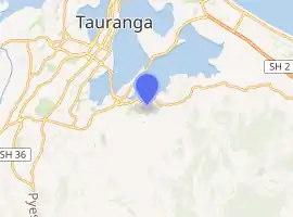
Welcome Bay is a suburb of Tauranga, New Zealand. It is located 7 kilometres (4.3 mi) from central Tauranga. Neighbouring suburbs include Hairini and Maungatapu. There are a number of schools in Welcome Bay, including three primary schools.[2]
Welcome Bay | |
|---|---|
Suburb | |

| |
| Country | New Zealand |
| Local authority | Tauranga |
| Electoral ward | Te Papa/Welcome Bay |
| Population (2018)[1] | |
| • Total | 10,284 |
| (Waimapu Estuary) | (Tauranga Harbour) | Maungatapu |
| Poike |
|
Welcome Bay |
| Oropi | Ohauiti |
The name Welcome Bay has been used for the area as early as 1872 by the Bay of Plenty Times.
Demographics
| Year | Pop. | ±% p.a. |
|---|---|---|
| 2006 | 7,527 | — |
| 2013 | 8,667 | +2.04% |
| 2018 | 10,284 | +3.48% |
| Source: [1] | ||
Welcome Bay, comprising the statistical areas of Kaitemako (Tauranga City), Welcome Bay West, Welcome Bay East and Welcome Bay South, had a population of 10,284 at the 2018 New Zealand census, an increase of 1,617 people (18.7%) since the 2013 census, and an increase of 2,757 people (36.6%) since the 2006 census. There were 3,372 households. There were 5,088 males and 5,199 females, giving a sex ratio of 0.98 males per female, with 2,493 people (24.2%) aged under 15 years, 1,833 (17.8%) aged 15 to 29, 4,656 (45.3%) aged 30 to 64, and 1,308 (12.7%) aged 65 or older.
Ethnicities were 80.1% European/Pākehā, 22.5% Māori, 3.3% Pacific peoples, 6.6% Asian, and 2.5% other ethnicities (totals add to more than 100% since people could identify with multiple ethnicities).
The proportion of people born overseas was 21.6%, compared with 27.1% nationally.
Although some people objected to giving their religion, 53.4% had no religion, 32.2% were Christian, 0.8% were Hindu, 0.1% were Muslim, 0.5% were Buddhist and 5.8% had other religions.
Of those at least 15 years old, 1,521 (19.5%) people had a bachelor or higher degree, and 1,203 (15.4%) people had no formal qualifications. The employment status of those at least 15 was that 4,035 (51.8%) people were employed full-time, 1,260 (16.2%) were part-time, and 330 (4.2%) were unemployed.[1]
| Name | Population | Median age | Median income |
|---|---|---|---|
| Kaitemako (Tauranga City) | 1,497 | 39 years | $32,600 |
| Welcome Bay West | 2,781 | 32.6 years | $32,800 |
| Welcome Bay East | 2,556 | 37.6 years | $28,600 |
| Welcome Bay South | 3,450 | 35.4 years | $37,000 |
| New Zealand | 37.4 years | $31,800 |
Marae
The local Tahuwhakatiki or Romai Marae and its Rongomainohorangi meeting house are a traditional meeting place for the Ngāti Ranginui hapū of Pirirākau.[3][4]
In October 2020, the Government committed $500,000 from the Provincial Growth Fund to upgrade the marae, creating 6 jobs.[5]
Climate
Welcome Bay is a sub-tropical climate zone, with warm humid summers and mild winters. Typical summer daytime maximum air temperatures range from 22°C to 26°C, but seldom exceed 30°C. Winter daytime maximum air temperatures range from 12°C to 17°C. Annual sunshine hours average least 2200 hours. Southwest winds prevail for much of the year. Sea breezes often occur on warm summer days. Winter usually has more rain and is the most unsettled time of year. In summer and autumn, storms of tropical origin may bring high winds and heavy rainfall from the east or northeast.[6]
Transport
Public transport in Welcome Bay solely consists of bus services. The suburb is served by one 'Bay Hopper' routes; Route 40(City - 15th Ave - Welcome Bay).[7]
Education
Welcome Bay has two co-educational state primary schools for Year 1 to 6 students: Welcome Bay School,[8][9] with a roll of 327,[10] and Selwyn Ridge School,[11][12] with a roll of 490.[13]
Rudolf Steiner School is a co-educational state-integrated primary school for Year 1 to 8 students,[14] with a roll of 194.[15]
Te Kura Kaupapa Māori o Otepou is a co-educational Māori language immersion school for Year 1 to 8 students,[16][17] with a roll of 50.[18]
References
- "Statistical area 1 dataset for 2018 Census". Statistics New Zealand. March 2020. Kaitemako (Tauranga City) (196300), Welcome Bay West (196600), Welcome Bay East (196700) and Welcome Bay South (196900). 2018 Census place summary: Kaitemako (Tauranga City) 2018 Census place summary: Welcome Bay West 2018 Census place summary: Welcome Bay East 2018 Census place summary: Welcome Bay South
- "Welcome Bay, Tauranga". www.qv.co.nz. Retrieved 10 January 2017.
- "Te Kāhui Māngai directory". tkm.govt.nz. Te Puni Kōkiri.
- "Māori Maps". maorimaps.com. Te Potiki National Trust.
- "Marae Announcements" (Excel). growregions.govt.nz. Provincial Growth Fund. 9 October 2020.
- "Climate". niwa.co.nz. NIWA. October 2017.
- "City 15th Ave Welcome Bay". baybus.co.nz. Bay Bus.
- "Welcome Bay School Official School Website". welcomebay.school.nz.
- "Welcome Bay School Ministry of Education School Profile". educationcounts.govt.nz. Ministry of Education.
- "Welcome Bay School Education Review Office Report". ero.govt.nz. Education Review Office.
- "Selwyn Ridge School Official School Website". selwynridge.school.nz.
- "Selwyn Ridge School Ministry of Education School Profile". educationcounts.govt.nz. Ministry of Education.
- "Selwyn Ridge School Education Review Office Report". ero.govt.nz. Education Review Office.
- "Rudolf Steiner School Ministry of Education School Profile". educationcounts.govt.nz. Ministry of Education.
- "Rudolf Steiner School Education Review Office Report". ero.govt.nz. Education Review Office.
- "Te Kura Kaupapa Māori o Otepou Official School Website". otepou.school.nz.
- "Te Kura Kaupapa Māori o Otepou Ministry of Education School Profile". educationcounts.govt.nz. Ministry of Education.
- "Te Kura Kaupapa Māori o Otepou Education Review Office Report". ero.govt.nz. Education Review Office.