Oropi
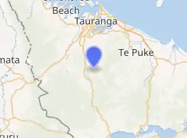
Oropi is a rural settlement located in the Bay of Plenty region of the North Island of New Zealand. It is located 20 kilometres south of Tauranga and 43 kilometres north of Rotorua. It has been suggested that the word Oropi is the Māori language equivalent of Europe. This is derived from the 1860s when government forces were based in the area at the time of the Battle of Gate Pā.[1]
Oropi | |
|---|---|

| |
| Coordinates: 37.839°S 176.158°E | |
| Country | |
| Region | Bay of Plenty |
| Territorial authority | Western Bay of Plenty |
| Ward | Kaimai |
| Population (2018) | |
| • Total | 2,520 |
The New Zealand Ministry for Culture and Heritage gives a translation of "place of covering up" for Ōropi.[2]
Oropi is mainly a farming community of both agriculture and horticulture ranging from kiwifruit orchards to dairy farms. Recently there has been some subdivision of farms into lifestyle blocks to take advantage of views of the coastline towards the Coromandel Peninsula and islands in the Bay of Plenty including Karewa (Gannet) Island, Mayor Island (Tuhua) and Motiti Island.[3]
Local facilities include a 9-hole golf course, hot pools, a paintball course and mountain bike tracks.[3] The Oropi Memorial Hall and Community Centre includes a 170 square metre auditorium.[4] The nearby Otanewainuku Forest, managed by the Department of Conservation, includes three short public walks.[5]
A sink hole developed on Oropi Road in August 2019,[6] caused by erosion from a stream.[7] The sinkhole was fixed in January 2020.[8]
Demographics
| Year | Pop. | ±% p.a. |
|---|---|---|
| 2006 | 1,953 | — |
| 2013 | 2,190 | +1.65% |
| 2018 | 2,520 | +2.85% |
| Source: [9] | ||
The statistical area of Waiorohi, which at 153 square kilometres is much larger than Oropi, had a population of 2,520 at the 2018 New Zealand census, an increase of 330 people (15.1%) since the 2013 census, and an increase of 567 people (29.0%) since the 2006 census. There were 825 households. There were 1,254 males and 1,266 females, giving a sex ratio of 0.99 males per female. The median age was 42.1 years (compared with 37.4 years nationally), with 492 people (19.5%) aged under 15 years, 468 (18.6%) aged 15 to 29, 1,260 (50.0%) aged 30 to 64, and 300 (11.9%) aged 65 or older.
Ethnicities were 91.2% European/Pākehā, 15.1% Māori, 1.1% Pacific peoples, 1.9% Asian, and 1.3% other ethnicities (totals add to more than 100% since people could identify with multiple ethnicities).
The proportion of people born overseas was 17.1%, compared with 27.1% nationally.
Although some people objected to giving their religion, 59.2% had no religion, 28.9% were Christian, 0.1% were Muslim, 0.2% were Buddhist and 2.5% had other religions.
Of those at least 15 years old, 396 (19.5%) people had a bachelor or higher degree, and 309 (15.2%) people had no formal qualifications. The median income was $35,200, compared with $31,800 nationally. The employment status of those at least 15 was that 1,104 (54.4%) people were employed full-time, 387 (19.1%) were part-time, and 48 (2.4%) were unemployed.[9]
Education
Oropi School is a co-educational state primary school for Year 1 to 8 students,[10][11] with a roll of 329 as of March 2020.[12]
The school has a community garden and a donated shipping container, which has been converted into an outdoor kitchen with a hand-painted forest mural on the outer wall.[13]
References
- "Oropi Primary School: About Us - History". Archived from the original on 5 February 2013. Retrieved 23 April 2013.
- "1000 Māori place names". New Zealand Ministry for Culture and Heritage. 6 August 2019.
- "Oropi". westernbay.govt.nz. Western Bay of Plenty District Council.
- "Oropi Memorial Hall & Community Centre". oropihall.co.nz. Oropi Hall.
- "Otanewainuku walking tracks". doc.govt.nz. Department of Conservation.
- Staff Reporter (1 August 2019). "Oropi Road still closed after sinkhole forms". Sun Media. sunlive.co.nz.
- "Permanent fix for Oropi Road sinkhole". Tauranga City Council. 13 January 2020.
- Staff Reporter (13 January 2020). "Permanent fix for Oropi Rd sinkhole to begin next week". New Zealand Media and Entertainment. Bay of Plenty Times.
- "Statistical area 1 dataset for 2018 Census". Statistics New Zealand. March 2020. Waiorohi (191700). 2018 Census place summary: Waiorohi
- "Oropi School Official School Website". oropi.school.nz.
- "Oropi School Ministry of Education School Profile". educationcounts.govt.nz. Ministry of Education.
- "Oropi School Education Review Office Report". ero.govt.nz. Education Review Office.
- Houghton, Caitlin (28 February 2020). "Painting a forest for Oropi School". Sun Media. Weekend Sun.