Saint-Félix, Charente
Saint-Félix is a commune in the Charente department in southwestern France.
Saint-Félix | |
|---|---|
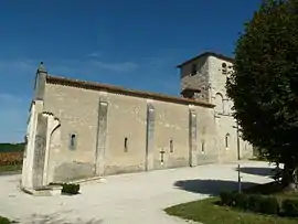 The church in Saint-Félix | |
Location of Saint-Félix 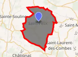
| |
 Saint-Félix  Saint-Félix | |
| Coordinates: 45°22′33″N 0°00′41″E | |
| Country | France |
| Region | Nouvelle-Aquitaine |
| Department | Charente |
| Arrondissement | Cognac |
| Canton | Charente-Sud |
| Intercommunality | Sud-Charente |
| Government | |
| • Mayor (2008–2014) | Marie-Claire Aubrit |
| Area 1 | 8.08 km2 (3.12 sq mi) |
| Population (2017-01-01)[1] | 111 |
| • Density | 14/km2 (36/sq mi) |
| Time zone | UTC+01:00 (CET) |
| • Summer (DST) | UTC+02:00 (CEST) |
| INSEE/Postal code | 16315 /16480 |
| Elevation | 84–175 m (276–574 ft) (avg. 150 m or 490 ft) |
| 1 French Land Register data, which excludes lakes, ponds, glaciers > 1 km2 (0.386 sq mi or 247 acres) and river estuaries. | |
Population
| Year | Pop. | ±% |
|---|---|---|
| 1793 | 460 | — |
| 1800 | 345 | −25.0% |
| 1806 | 490 | +42.0% |
| 1821 | 471 | −3.9% |
| 1831 | 455 | −3.4% |
| 1841 | 464 | +2.0% |
| 1846 | 477 | +2.8% |
| 1851 | 458 | −4.0% |
| 1856 | 414 | −9.6% |
| 1861 | 429 | +3.6% |
| 1866 | 410 | −4.4% |
| 1872 | 372 | −9.3% |
| 1876 | 368 | −1.1% |
| 1881 | 355 | −3.5% |
| 1886 | 321 | −9.6% |
| 1891 | 302 | −5.9% |
| 1896 | 277 | −8.3% |
| 1901 | 292 | +5.4% |
| 1906 | 281 | −3.8% |
| 1911 | 270 | −3.9% |
| 1921 | 243 | −10.0% |
| 1926 | 246 | +1.2% |
| 1931 | 250 | +1.6% |
| 1936 | 258 | +3.2% |
| 1946 | 236 | −8.5% |
| 1954 | 212 | −10.2% |
| 1962 | 179 | −15.6% |
| 1968 | 205 | +14.5% |
| 1975 | 175 | −14.6% |
| 1982 | 136 | −22.3% |
| 1990 | 118 | −13.2% |
| 1999 | 119 | +0.8% |
| 2008 | 113 | −5.0% |
See also
References
- "Populations légales 2017". INSEE. Retrieved 6 January 2020.
| Wikimedia Commons has media related to Saint-Félix (Charente). |
| Authority control |
|---|
This article is issued from Wikipedia. The text is licensed under Creative Commons - Attribution - Sharealike. Additional terms may apply for the media files.