Meteorological history of Hurricane Laura
Hurricane Laura tied the record for the strongest hurricane to make landfall in Louisiana as measured by maximum sustained winds, along with the 1856 Last Island hurricane, and was overall the tenth-strongest hurricane to make landfall in the United States. The thirteenth tropical cyclone, twelfth named storm, fourth hurricane, and first major hurricane of the 2020 Atlantic hurricane season, Laura originated from a large tropical wave that moved off the West African coast on August 16. The tropical wave gradually organized, becoming a tropical depression on August 20. Though in only a marginally conducive environment for intensification, the depression nevertheless intensified into a tropical storm a day later, becoming the earliest twelfth named storm on record in the North Atlantic basin, forming eight days earlier than 1995's Hurricane Luis. The depression received the name Laura and tracked west-northwest towards the Lesser Antilles.
| Category 4 major hurricane (SSHWS/NWS) | |
 Map plotting the track and the intensity of the storm, according to the Saffir–Simpson scale | |
| Formed | August 20, 2020 |
|---|---|
| Dissipated | August 29, 2020 |
| Highest winds | 1-minute sustained: 150 mph (240 km/h) |
| Lowest pressure | 937 mbar (hPa); 27.67 inHg |
| Areas affected | Lesser Antilles, Puerto Rico, Hispaniola, Cuba, Jamaica, Cayman Islands, Gulf Coast of the United States (primarily Mississippi, Louisiana, and Texas), Arkansas, Missouri, Ohio Valley |
| Part of the 2020 Atlantic hurricane season | |
Laura first hit the Lesser Antilles and brushed Puerto Rico as a tropical storm, before it moved across the island of Hispaniola. The storm killed 21 people in Haiti and four in the Dominican Republic. The storm later moved across the length of Cuba, while maintaining its intensity as convection was mainly to the south of the island, although its outer rainbands extended into the Florida Keys and South Florida. Laura moved across the Gulf of Mexico, strengthening slowly at first, before a period of rapid intensification began on August 26. That day, Laura became a major hurricane, and later attained peak winds of 150 mph (240 km/h), making it a strong Category 4 hurricane, with its pressure bottoming out at 937 mbar (27.7 inHg). Early on August 27, Laura made landfall near peak intensity on Cameron, Louisiana with 150 miles per hour (240 km/h) winds, with a minimum central pressure of 938 mbar (27.7 inHg). It quickly weakened over land, degrading to a tropical storm over Northwestern Louisiana before dropping to tropical depression status near Pine Bluff, Arkansas on August 28. It turned eastward and became a remnant low over Kentucky on August 29 before being absorbed by an extratropical low over Maryland several hours later.
Origins and early development

On August 16, a large tropical wave moved off the coast of Africa.[1] The same day, the National Hurricane Center noted the possibility of tropical development as the wave neared more favorable conditions, with the 5-day development chance being estimated at 20%.[2] The next day, the wave entered more favorable developmental conditions and the NHC raised the 5-day development chance to 50%.[3] It then merged with another disturbance to its west and a low-pressure area formed, prompting the NHC to raise the 5-day development potential to 90%.[4] The low continued to slowly organize with rainbands apparent and a well-defined low-level center forming. Eventually, the NHC determined that the low had organized enough to be declared a tropical cyclone and began issuing advisories on Tropical Depression Thirteen at 03:00 UTC on August 20. At the time, it was located around 1035 miles (1670 km) east-southeast of the Northern Leeward Islands. The Bermuda High over the Central Atlantic built westward, which in turned steered the system west-northwestward.[5] The system would be steered around this ridge for its entire existence.[6] Environmental conditions featured mixed signals for intensification, including low wind shear and dry air from the Saharan Air Layer. Accordingly forecast models displayed solutions ranging from the system degrading back into a tropical wave all the way to becoming a major hurricane within the next five days.[7]

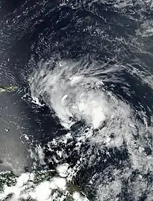
Initial aircraft reconnaissance into the system late on August 20 into August 21 revealed a poorly organized system with an ill-defined, elongated surface low.[8] Furthermore, the system's mid-level circulation was displaced several hundred miles southeast of the assumed surface circulation. During the early part of August 21, the depression may have degenerated into a tropical wave, although the NHC continued to issue advisories on the system.[9] The depression continued to struggle because of significant mid-level wind shear, dry air, and its fast forward motion of over 20 mph (32 km/h).[10] However, a Hurricane Hunters flight on August 21 observed gale-force winds and a center farther south then previously estimated. Consequently, the National Hurricane Center upgraded the depression to a tropical storm and named it Laura at 13:05 UTC.[11] Laura became the earliest twelfth named Atlantic storm ever recorded, beating the record of Hurricane Luis of 1995 by eight days. At the time, Laura was located around 230 miles (375 km) east-southeast of the northern Leeward Islands. Despite being stronger, Laura remained poorly organized due to moderate wind shear as it moved over the Leeward Islands, with most of its convection and strongest winds located north and east of the center of circulation.[12] Eventually, Laura became slightly better organized and it strengthened a little as it passed south of Puerto Rico, although its center remained elongated.[13][14] During the afternoon of August 22, a strong mesocyclone within the storm's broader circulation impacted Puerto Rico; sustained winds associated with this feature reached 60 mph (97 km/h) in Las Marías, although this was not representative of the storm's actual intensity.[15] Laura then made landfall near San Pedro de Macorís, Dominican Republic at around 03:00 UTC on August 23 with 1-minute sustained winds of 50 mph (85 km/h) and a pressure of 1003 mbars (29.62 inHg).[14]
Trek through the Greater Antilles

Despite moving over rugged, mountainous terrain, normally an impediment to tropical cyclone organization, the large size of Laura allowed it to maintain most of its intensity as it moved over Hispaniola and the overall structure of the storm actually improved with expanding upper-level outflow and intense convection over the Barahona Peninsula. Continuing to move west-northwestward around the southern side of the Bermuda High building westward over the Southeastern U.S., Laura moved back over water in the Windward Passage and strengthened some before making landfall in Eastern Cuba with 60 mph (95 km/h) winds and a 1000 mbar (29.53 inHg) pressure at 00:00 UTC on August 24.[16][17] Laura structure continued to improve even though it was over land and winds maxed out at 65 mph (100 km/h) at 03:00 UTC.[18] However, most of its convection was located south of the center due to wind shear.[19] Continuing to trek west-northwestward, Laura moved back over the Caribbean Sea just south of the coast of Cuba after being over land for six hours.[20] A period of dry air entertainment coupled with the continued effects of moderate northerly shear and land interaction briefly degraded and weakened the storm as it struggled to remain organized throughout August 24 due to the lack of a defined inner-core with the most intense accompanying convection in a prominent band south of the circulation center.[21] However, this turned out to be short-lived as Laura reorganized and restrengthened over the warm waters of the Caribbean before making landfall on the western tip of Cuba in Pinar del Rio province at around 00:00 UTC on August 25. At the time, it had 65 mph (105 km/h) winds and a 998 mbar (29.47 inch) pressure.[22][23]
Gulf of Mexico, rapid intensification and landfall

After clearing Cuba, Laura quickly began to gain more organization as it moved west-northwestward into the warm waters of the Gulf of Mexico.[24] The organization was accompanied by steady strengthening, and Laura was upgraded to a Category 1 hurricane at 12:15 UTC on August 25 after hurricane hunters found hurricane-force winds at the surface.[25] Laura then developed an inner core and a central dense overcast (CDO), although it still had a somewhat ragged appearance on satellite imagery.[26] Its intensification continued to be slow due to the presence of some dry air and light northerly wind shear, but this eventually subsided, allowing Laura to become more organized and form a banding-type cloud-filled eye late on August 25.[27] With no more negative factors hindering strengthening and sea surface temperatures around 30 °C, Laura began to rapidly intensify, becoming a Category 2 at 06:00 UTC on August 26 before achieving Category 3 status just six hours later, making it the first major hurricane of the season.[28][29] By this time, Laura was beginning to make a gradual northward turn around the high-pressure ridge in front of a mid-to-upper-level trough over Texas and the Southern Great Plains.[30]

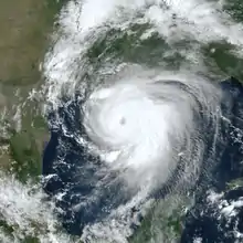
As the day progressed, Laura's eye continued to clear out and the deep convection around it intensified and became more symmetric.[31] The satellite presentation continued to improve with the eye becoming better defined, and cloud tops colder than -70 °C in the surrounding ring of deep convection in the developing eyewall.[32] Laura continued to rapidly strengthen that afternoon and reached Category 4 intensity at 18:00 UTC.[33] The hurricane's eye reached a diameter of 30 mi (45 km) that evening and aircraft reconnaissance indicated it to have acquired sustained winds of 145 mph (230 km/h) by 21:00 UTC; this represented an increase of 65 mph (100 km/h) over a 24-hour period.[34] Laura's structure continued to improve with a very distinct, 25 nautical-mile-wide eye embedded in a symmetric central dense overcast and upper-level outflow becoming well established in all quadrants of the cyclone.[34] As it turned north-northwestward towards the Louisiana coastline, Laura reached its peak intensity at 01:00 UTC on August 27 as a high-end Category 4 hurricane with 1-minute sustained winds 150 mph (240 km/h) and a minimum central pressure of 937 mbar (hPa; 27.67 inHg), as measured by reconnaissance aircraft. At this point, the hurricane was located south of Lake Charles, Louisiana and south-southeast of Port Arthur, Texas by a distance of 95 miles (155 km) each.[35]
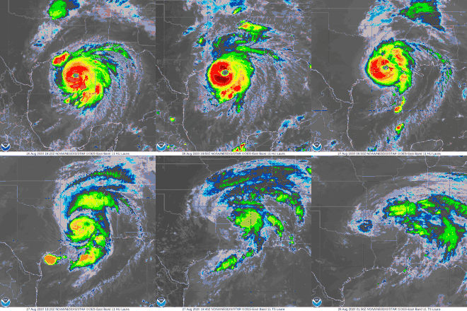
Two hours after reaching its peak intensity, Laura began to experience some shear from the trough to its west, finally halting it intensification phase. The outflow became restricted on its west side and its pressure began to fluctuate.[36][37][38] However, Laura continued to have a very impressive appearance on satellite imagery.[39] Turning almost due north, Laura made its final landfall near Cameron, Louisiana at 06:00 UTC with 150 mph (240 km/h) winds and a pressure of 938 mbars (27.70 inches).[40] The wind speed made Laura the first Category 4 hurricane to ever hit southwestern Louisiana as well as the strongest hurricane to hit the state since the 1856 Last Island hurricane.[41] Forecasters at the NHC described the system as "a ferocious looking hurricane with a clear circular eye, an intense eyewall, and tightly-coiled surrounding spiral bands."[42]
Demise

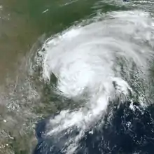
After landfall, Laura continued to move northward through the western side of Louisiana. It passed just west of Lake Charles, Louisiana while still at Category 4 intensity with sustained winds at the Lake Charles Regional Airport reaching 95 mph (153 km/h) with gusts up to 132 mph (212 km/h).[43] Despite this, Laura was already beginning to quickly weaken and its winds dropped to Category 3 intensity halfway between De Quincy and Oretta at 09:00 UTC before weakening to below major hurricane strength north of Singer just an hour later.[44][45] Steadily turning more northeastward, Laura dropped to Category 1 status south of Natchitoches, Louisiana at 14:00 UTC as its eye filled and its satellite and radar appearance degraded.[46][47] It weakened further to a tropical storm north of Arcadia at 17:00 UTC before moving into Southern Arkansas, where wind gusts in the state reached nearly 60 mph (95 km/h).[48][49] Convection around the storm center weakened further as the storm passed just east of Little Rock. Laura was downgraded to a tropical depression shortly after that at 03:00 UTC on August 28 and the responsibilities for issuing advisories on the storm was handed off to the Weather Prediction Center (WPC) since there was still a flood threat.[50]
Laura then accelerated as it turned northeastward and then east-northeastward as it began to lose tropical characteristics ahead of an approaching trough from the west. It moved through Southeastern Missouri and turned eastward into Kentucky before becoming over remnant low in Head of Grassy at 09:00 UTC on August 29 and the WPC issued its final advisory as the flood threat was generally over.[51][52] The low continued eastward through West Virginia and Extreme Northern Virginia before being absorbed by an approaching extratropical system over Maryland several hours later.[53][54][55]
See also
- List of Category 4 Atlantic hurricanes
- 2020 Atlantic hurricane season
- Hurricane Lili (2002) – Another Category 4 hurricane that took a similar track, although it rapidly weakened before landfall.
- Meteorological history of Hurricane Gustav – Another category 4 hurricane that took a similar track in 2008
- Hurricane Isaac (2012) – Category 1 hurricane that struck Louisiana after moving through the Caribbean as a tropical storm
References
- "NHC Graphical Outlook Archive". www.nhc.noaa.gov. Retrieved 3 September 2020.
- Robbie Berg (August 16, 2020). "Five-Day Graphical Tropical Weather Outlook". www.nhc.noaa.gov. Miami, Florida: National Hurricane Center. Retrieved August 20, 2020.
- "NHC Graphical Outlook Archive". www.nhc.noaa.gov.
- "NHC Graphical Outlook Archive". www.nhc.noaa.gov.
- "Tropical Depression THIRTEEN". www.nhc.noaa.gov. Retrieved 3 September 2020.
- "Hurricane LAURA Advisory Archive". www.nhc.noaa.gov. Retrieved 4 September 2020.
- Jack Beven (August 20, 2020). Tropical Depression Thirteen Discussion Number 2 (Report). National Hurricane Center. Archived from the original on August 27, 2020. Retrieved August 31, 2020.
- Eric Blake (August 21, 2020). Tropical Depression Thirteen Discussion Number 5 (Report). National Hurricane Center. Archived from the original on August 27, 2020. Retrieved August 31, 2020.
- Jack Beven (August 21, 2020). Tropical Depression Thirteen Discussion Number 6 (Report). National Hurricane Center. Archived from the original on August 27, 2020. Retrieved August 31, 2020.
- "Tropical Depression THIRTEEN". www.nhc.noaa.gov. Retrieved 3 September 2020.
- "Tropical Storm LAURA". www.nhc.noaa.gov. Retrieved 2 September 2020.
- "Tropical Storm LAURA". www.nhc.noaa.gov. Retrieved 3 September 2020.
- "Tropical Storm LAURA". www.nhc.noaa.gov. Retrieved 3 September 2020.
- "Tropical Storm LAURA". www.nhc.noaa.gov. Retrieved 3 September 2020.
- Richard Pasch (August 22, 2020). Tropical Storm Laura Discussion Number 12 (Report). National Hurricane Center. Archived from the original on August 27, 2020. Retrieved August 31, 2020.
- "Tropical Storm LAURA". www.nhc.noaa.gov. Retrieved 4 September 2020.
- "Tropical Storm LAURA". www.nhc.noaa.gov. Retrieved 2 September 2020.
- "Tropical Storm LAURA". www.nhc.noaa.gov. Retrieved 2 September 2020.
- "Tropical Storm LAURA". www.nhc.noaa.gov. Retrieved 3 September 2020.
- "Tropical Storm LAURA". www.nhc.noaa.gov. Retrieved 3 September 2020.
- "Tropical Storm LAURA". www.nhc.noaa.gov. Retrieved 3 September 2020.
- "Tropical Storm LAURA". www.nhc.noaa.gov. Retrieved 3 September 2020.
- "Tropical Storm LAURA". www.nhc.noaa.gov. Retrieved 3 September 2020.
- "Tropical Storm LAURA". www.nhc.noaa.gov. Retrieved 3 September 2020.
- "Hurricane LAURA". www.nhc.noaa.gov. Retrieved 3 September 2020.
- "Hurricane LAURA". www.nhc.noaa.gov. Retrieved 3 September 2020.
- "Hurricane LAURA". www.nhc.noaa.gov. Retrieved 3 September 2020.
- "Hurricane LAURA". www.nhc.noaa.gov. Retrieved 4 September 2020.
- "Hurricane LAURA". www.nhc.noaa.gov. Retrieved 4 September 2020.
- "Hurricane LAURA". www.nhc.noaa.gov. Retrieved 4 September 2020.
- "Hurricane LAURA". www.nhc.noaa.gov. Retrieved 4 September 2020.
- "Hurricane LAURA". www.nhc.noaa.gov. Retrieved 4 September 2020.
- "Hurricane LAURA". www.nhc.noaa.gov. Retrieved 4 September 2020.
- Daniel Brown (August 26, 2020). Hurricane Laura Discussion Number 28 (Report). National Hurricane Center. Archived from the original on August 28, 2020. Retrieved August 31, 2020.
- "Hurricane LAURA". www.nhc.noaa.gov. Retrieved 4 September 2020.
- "Hurricane LAURA". www.nhc.noaa.gov. Retrieved 4 September 2020.
- "Hurricane LAURA". www.nhc.noaa.gov. Retrieved 4 September 2020.
- "Hurricane LAURA". www.nhc.noaa.gov. Retrieved 4 September 2020.
- "Hurricane LAURA". www.nhc.noaa.gov. Retrieved 4 September 2020.
- "Hurricane LAURA". www.nhc.noaa.gov. Retrieved 4 September 2020.
- "Hurricane Laura the First Southwest Louisiana Category 4 Landfall on Record With Destructive Winds, Storm Surge". The Weather Channel. August 28, 2020. Retrieved August 31, 2020.
- John Cangialosi and David Zelinsky (August 27, 2020). Hurricane Laura Discussion Number 30 (Report). National Hurricane Center. Archived from the original on August 27, 2020. Retrieved August 31, 2020.
- David Zelinsky, John Cangialosi, and Eric Blake (August 27, 2020). Hurricane Laura Tropical Cyclone Update (Report). National Hurricane Center. Archived from the original on August 27, 2020. Retrieved August 31, 2020.CS1 maint: multiple names: authors list (link)
- "Hurricane LAURA". www.nhc.noaa.gov. Retrieved 4 September 2020.
- "Hurricane LAURA". www.nhc.noaa.gov. Retrieved 4 September 2020.
- "Hurricane LAURA". www.nhc.noaa.gov. Retrieved 4 September 2020.
- "Hurricane LAURA". www.nhc.noaa.gov. Retrieved 4 September 2020.
- "Tropical Storm LAURA". www.nhc.noaa.gov. Retrieved 4 September 2020.
- "Tropical Storm LAURA". www.nhc.noaa.gov. Retrieved 4 September 2020.
- "Tropical Depression LAURA". www.nhc.noaa.gov. Retrieved 4 September 2020.
- "Tropical Depression LAURA". www.nhc.noaa.gov. Retrieved 4 September 2020.
- "Post-Tropical Cyclone LAURA". www.nhc.noaa.gov. Retrieved 4 September 2020.
- Service, NOAA's National Weather. "WPC Surface Analysis Archive". www.wpc.ncep.noaa.gov. Retrieved 4 September 2020.
- "WPC Surface Analysis valid for 08/29/2020 at 18 UTC". wpc.ncep.noaa.gov. Weather Prediction Center. August 29, 2020. Retrieved September 1, 2020.
- "WPC Surface Analysis valid for 08/29/2020 at 21 UTC". wpc.ncep.noaa.gov. Weather Prediction Center. August 29, 2020. Retrieved September 1, 2020.
External links
- The National Hurricane Center's Advisory Archive on Hurricane Laura
- National Hurricane Center (NHC)
- Weather Prediction Center (WPC)
