Machias River (Aroostook River tributary)
The Machias River is a major tributary of the Aroostook River, flowing 33.4 miles (53.8 km)[1] through Aroostook County in the northern part of the state of Maine, USA. From the outflow of Big Machias Lake (46°40′45″N 68°45′54″W) in Maine Township 12, Range 8, WELS, the river runs southeast and east to its confluence with the Aroostook in Ashland.
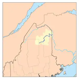
The Aroostook River watershed
This article is about the Aroostook County river. For the Washington County river, see Machias River.
| Machias River | |
|---|---|
| Location | |
| Country | United States |
| Physical characteristics | |
| Source | |
| • location | Maine |
| Mouth | |
• location | Aroostook River |
• coordinates | 46°37′19″N 68°25′17″W |
• elevation | 530 feet (160 m) |
| Length | 33 miles (53 km) |
| Basin features | |
| Progression | Aroostook — St. John — Bay of Fundy |
See also
- List of Maine rivers
References
- U.S. Geological Survey. National Hydrography Dataset high-resolution flowline data. The National Map Archived 2012-04-05 at WebCite, accessed June 22, 2011
External links
- "Machias River". Geographic Names Information System. United States Geological Survey. 30 September 1980. Retrieved 2010-03-09.
| Bay of Fundy |
| ||||||||||||||||||||||||||||||
|---|---|---|---|---|---|---|---|---|---|---|---|---|---|---|---|---|---|---|---|---|---|---|---|---|---|---|---|---|---|---|---|
| Casco Bay |
| ||||||||||||||||||||||||||||||
| Gulf of Maine |
| ||||||||||||||||||||||||||||||
| Merrymeeting Bay |
| ||||||||||||||||||||||||||||||
| Muscongus Bay |
| ||||||||||||||||||||||||||||||
| Penobscot Bay |
| ||||||||||||||||||||||||||||||
| Saco Bay |
| ||||||||||||||||||||||||||||||
This article is issued from Wikipedia. The text is licensed under Creative Commons - Attribution - Sharealike. Additional terms may apply for the media files.