La Chapelle-Vendômoise
La Chapelle-Vendômoise is a commune in the Loir-et-Cher department in central France.
La Chapelle-Vendômoise | |
|---|---|
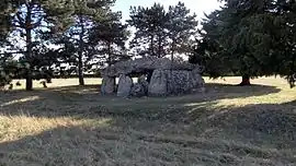 Dolmen de la Pierre Levée | |
Location of La Chapelle-Vendômoise 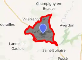
| |
 La Chapelle-Vendômoise  La Chapelle-Vendômoise | |
| Coordinates: 47°40′18″N 1°14′24″E | |
| Country | France |
| Region | Centre-Val de Loire |
| Department | Loir-et-Cher |
| Arrondissement | Blois |
| Canton | Onzain |
| Intercommunality | Beauce - Val de Cisse |
| Government | |
| • Mayor (2014–2020) | François Borde |
| Area 1 | 13.07 km2 (5.05 sq mi) |
| Population (2017-01-01)[1] | 783 |
| • Density | 60/km2 (160/sq mi) |
| Time zone | UTC+01:00 (CET) |
| • Summer (DST) | UTC+02:00 (CEST) |
| INSEE/Postal code | 41040 /41330 |
| Elevation | 87–131 m (285–430 ft) (avg. 117 m or 384 ft) |
| 1 French Land Register data, which excludes lakes, ponds, glaciers > 1 km2 (0.386 sq mi or 247 acres) and river estuaries. | |
Population
| Year | Pop. | ±% |
|---|---|---|
| 1793 | 347 | — |
| 1806 | 329 | −5.2% |
| 1821 | 344 | +4.6% |
| 1831 | 424 | +23.3% |
| 1841 | 451 | +6.4% |
| 1851 | 502 | +11.3% |
| 1861 | 485 | −3.4% |
| 1872 | 486 | +0.2% |
| 1881 | 528 | +8.6% |
| 1891 | 523 | −0.9% |
| 1901 | 472 | −9.8% |
| 1911 | 468 | −0.8% |
| 1921 | 438 | −6.4% |
| 1931 | 430 | −1.8% |
| 1946 | 427 | −0.7% |
| 1954 | 424 | −0.7% |
| 1962 | 424 | +0.0% |
| 1968 | 421 | −0.7% |
| 1975 | 553 | +31.4% |
| 1982 | 623 | +12.7% |
| 1990 | 708 | +13.6% |
| 1999 | 744 | +5.1% |
| 2008 | 748 | +0.5% |
| 2013 | 721 | −3.6% |
References
- "Populations légales 2017". INSEE. Retrieved 6 January 2020.
| Wikimedia Commons has media related to La Chapelle-Vendômoise. |
| Authority control |
|---|
This article is issued from Wikipedia. The text is licensed under Creative Commons - Attribution - Sharealike. Additional terms may apply for the media files.