Interstate 76 (Colorado–Nebraska)
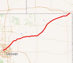
Interstate 76 (I-76) is an Interstate Highway in the Western United States that runs from Interstate 70 in Arvada, Colorado (near Denver) to an intersection with Interstate 80 near Big Springs, Nebraska. All but three miles of the highway's route is in Colorado.
| |||||||
|---|---|---|---|---|---|---|---|
I-76 highlighted in red | |||||||
| Route information | |||||||
| Length | 187.29 mi[1][2] (301.41 km) | ||||||
| Existed | 1975–present | ||||||
| Major junctions | |||||||
| West end | |||||||
| |||||||
| North end | |||||||
| Location | |||||||
| States | Colorado, Nebraska | ||||||
| Counties | CO: Jefferson, Adams, Weld, Morgan, Washington, Logan, Sedgwick NE: Deuel | ||||||
| Highway system | |||||||
| |||||||

Route description
| mi | km | |
|---|---|---|
| CO | 184.14 | 296.34 |
| NE | 3.15 | 5.07 |
| Total | 187.29 | 301.41 |
Colorado
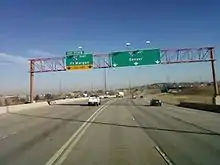
Interstate 76 begins at an interchange with I-70 in Arvada. From I-70, the freeway heads east to an exit at SH 95, known as Sheridan Boulevard. The route heads northeastward across US 287, known as Federal Boulevard, to an interchange with I-25. Running roughly parallel to nearby Clear Creek, I-76 meets another interchange, with Interstate 270 in North Washington, Colorado, where Clear Creek joins the South Platte River, which is crossed by I-76. After an interchange at SH 224, I-76 joins US 85 and US 6 at Brighton Boulevard. Past Derby, US 85 veers away from I-76 at Dayton Way. The combined routes of US 6 and I-76 head northeastward, crossing SH 2, named Sable Boulevard, before meeting an exit at E-470, a toll road. Past E-470, the freeway exits the Denver-Aurora metropolitan area.
Passing just west of Barr Lake, the freeway heads northeastward east of Brighton. Near Lochbuie, the freeway crosses SH 7 before crossing into Weld County. I-76 meets SH 52 in Hudson, the next city along the freeway. Past Hudson, the combined routes of US 6 and I-76 turn slightly eastward into Keenesburg, which is served by a business loop (I-76 BUS). I-76 then turns northeast and east into Roggen, where it meets County Road 73. The highway heads away from the farmland it was formerly running through and traverses a large grassland area. Just south of the Empire Reservoir, the freeway turns back east, crossing into Morgan County within circular fields. Heading east, I-76 heads into Wiggins, near which I-76 joins US 34. The three combined routes head east through farms.
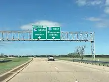
The freeway heads east toward Fort Morgan, spawning another business loop that carries US 34 away from I-76. The freeway heads east into Fort Morgan, meeting SH 52, now running again near South Platte River. Still running between South Platte River to the north and its business loop to the south, I-76 heads just north of Brush, where it meets a cloverleaf interchange with SH 71. US 34 veers away from the business loop as I-76 turns back east, crossing over the business loop, which does not terminate at the freeway. I-76 BUS carries US 6 toward Hillrose. Bypassing that city, I-76 traverses northeast into Washington County, with farms to the north along the river and grasslands to the south. Passing the Prewitt Reservoir, the freeway heads into Logan County. Heading northeasterly, the route crosses SH 63, which serves Atwood. I-76 BUS then enters Sterling, which is near I-76. The business loops turns abruptly east within the city, carrying US 6. US 6 continues past the interchange with the business route.
I-76 continues parallel to South Platte River, surrounded by farms to the northwest and plains to the southeast. Northwest of the river is US 138, which serves several towns bypassed by the freeway. I-76 has an exit at SH 55 which serves the town of Crook. With farms on the south part of the freeway as well, I-76 enters Sedgwick County, crossing SH 59 which heads to Sedgwick. The freeway then veers eastward before turning back northeast toward Julesburg. I-76 comes to an exit at U.S. Highway 385, which heads northwest to Julesburg. I-76 then heads northeast to the Nebraska state line.[3] [4]
Nebraska
In Nebraska, I-76 stretches just over three miles (5 km). It is signed as a north–south direction as opposed to the east–west designation in Colorado. Its entire route is located in Deuel County, parallel to the South Platte River and U.S. Highway 138. Its only interchange is at Interstate 80, numbered exit 102 based on I-80's mileage.
History

Until 1975, both the western segment of Interstate 76 and a portion of the eastern Interstate 76 were signed as Interstate 80S. In July 1976, the already-completed route, I-80S, was renumbered to I-76 in accordance with American Association of State Highway and Transportation Officials (AASHTO) policy to remove the letter suffixes from Interstate routes and to avoid the confusion of this route with Interstate 80. This prompted the replacement of around 500 signs in eliminating I-80S. The number, "76", has an association with 1876, the year Colorado was admitted as a state.
I-76 was conceived in August 1958. The Colorado portion was planned and built first. In December 1969, the Nebraska Department of Roads worked together with the Colorado Department of Highways to open a three-mile (5 km) long route connecting Interstate 80 with the rest of I-80S in Colorado.[1] The original western terminus of I-76 was at I-25, as planned. The western extension to Interstate 70 was built in the late 1980s and early 1990s. By its completion in November 2002, the total cost was about $45.5 million.[1]
In 1968, Interstate 25 and U.S. Highway 85 were open to the general traffic to the Denver vicinity after all the structures located throughout the route were completed, as well as meeting the criteria of the Interstate standards. Structures connected several interchanges; each one connecting Interstate 270, U.S. Highway 85, Dahlia Street, Washington Street, 74th Avenue, and York Street. The completion also included structures in which each cross the Burlington Canal, Platte River, and the Union Pacific Railroad. By October 24, 1970, the route was open to traffic from Sedgwick to Julesburg, as well as the completion of the route, connecting from its western terminus of I-25 in Colorado to its eastern terminus at I-80 near Big Springs, Nebraska.[1]
Beginning in 1990, six additional miles were planned and constructed west of I-25. By October 2002, all of I-76 was open, and the highway reached its current western terminus at Interstate 70 at Arvada.[1]
Exit list
| State | County | Location | mi[5][2] | km | Exit | Destinations | Notes |
|---|---|---|---|---|---|---|---|
| Colorado | Jefferson | Arvada | 0.000– 0.538 | 0.000– 0.866 | Western terminus; I-70 exit 269B | ||
| 0.000 | 0.000 | 1A | Westbound exit and eastbound entrance | ||||
| Jefferson–Adams county line | Arvada–Berkley line | 1.768 | 2.845 | 1B | |||
| Adams | Berkley | 3.223 | 5.187 | 3 | |||
| Berkley–North Washington line | 4.210 | 6.775 | 4 | Pecos Street | |||
| North Washington | 5.777 | 9.297 | 5 | Westbound access to I-25 north is via exit 6B; I-25 exits 216A-B | |||
| 6.803 | 10.948 | 6 | Serves Denver International Airport | ||||
| 6.803 | 10.948 | Westbound exit and entrance only; I-270 exit 1 | |||||
| | 8.052 | 12.958 | 8 | Eastbound exit and westbound entrance | |||
| | 9.483 | 15.261 | 9 | Western end of US 6 / US 85 overlap; westbound exit and eastbound entrance | |||
| | 10.466 | 16.843 | 10 | 88th Avenue | |||
| | 11.549 | 18.586 | 11 | 96th Avenue | |||
| | 12.502 | 20.120 | 12 | Eastern end of US 85 overlap; no eastbound entrance | |||
| Brighton | 16.477 | 26.517 | 16 | ||||
| 18.079 | 29.095 | 18 | Westbound exit and eastbound entrance; E-470 exit 35 | ||||
| 19.723 | 31.741 | 20 | 136th Avenue | ||||
| 21.081 | 33.927 | 21 | Eagle Boulevard | ||||
| 22.407 | 36.061 | 22 | Bromley Lane | ||||
| Lochbuie | 25.145 | 40.467 | 25 | ||||
| Weld | Hudson | 31.480 | 50.662 | 31 | |||
| 34.412 | 55.381 | 34 | Kersey Road | ||||
| | 38.925 | 62.644 | 39 | Keenesburg | |||
| | 47.972 | 77.203 | 48 | Roggen | |||
| | 49.236 | 79.238 | 49 | Painter Road | Westbound exit and eastbound entrance | ||
| | 57.219 | 92.085 | 57 | County Road 91 | |||
| | 60 | ||||||
| Morgan | | 63.883 | 102.810 | 64 | Wiggins | Eastbound exit and westbound entrance | |
| | 66.099 | 106.376 | 66A | Western end of SH 52 overlap | |||
| | 66.288 | 106.680 | 66B | Western end of US 34 overlap; westbound exit and eastbound entrance | |||
| | 73.130 | 117.691 | 73 | Long Bridge Road | |||
| | 75.280 | 121.151 | 75 | Eastern end of US 34 overlap; eastern end of SH 52 overlap | |||
| | 78.852 | 126.900 | 79 | ||||
| Fort Morgan | 80.139 | 128.971 | 80 | ||||
| 81.648 | 131.400 | 82 | Barlow Road – Fort Morgan | ||||
| | 85.713 | 137.942 | 86 | Dodd Bridge Road | |||
| | 88.695 | 142.741 | 89 | Hospital Road | |||
| | 89.643 | 144.266 | 90 | ||||
| | 91.693 | 147.566 | 92 | Eastern end of US 6 overlap | |||
| | 95.382 | 153.502 | 95 | Hillrose | |||
| Washington | | 102.086 | 164.291 | 102 | Merino | ||
| Logan | | 115.197 | 185.392 | 115 | |||
| Sterling | 124.756 | 200.775 | 125 | ||||
| | 133.511 | 214.865 | 134 | Iliff | |||
| | 140.846 | 226.670 | 141 | Proctor | |||
| | 148.880 | 239.599 | 149 | ||||
| | 155.288 | 249.912 | 155 | Red Lion Road | |||
| Sedgwick | | 164.933 | 265.434 | 165 | |||
| | 172.017 | 276.835 | 172 | Ovid | |||
| Julesburg | 180.221 | 290.038 | 180 | ||||
| 184.14 0.00 | 296.34 0.00 | Colorado–Nebraska state line | |||||
| Nebraska | Deuel | | 2.07– 3.15 | 3.33– 5.07 | – | Eastern terminus; I-80 exit 102 | |
| 1.000 mi = 1.609 km; 1.000 km = 0.621 mi | |||||||
Business routes
Keenesburg
| |
|---|---|
| Location | Keenesburg |
| Length | 0.30 mi (0.48 km) |
State Highway 76B is an unsigned business spur that connects Keenesburg in Weld County to the interstate. Inventoried by the Colorado Department of Transportation (CDOT), the 0.3-mile (0.48 km) route begins at Interstate 76 Frontage Road within the town limits and heads north as Market Street. The route terminates at exit 39 at a diamond interchange on I-76.[6]
Major intersections
The entire route is in Weld County.
| Location | mi | km | Destinations | Notes | |
|---|---|---|---|---|---|
| Keenesburg | 0.000 | 0.000 | Interstate 76 Frontage Road | Southern terminus; Market Street continues and becomes Elm Street | |
| | 0.030 | 0.048 | Northern terminus; Market Street continues and terminates at County Road 18 | ||
| 1.000 mi = 1.609 km; 1.000 km = 0.621 mi | |||||
Fort Morgan–Sterling
| |
|---|---|
| Location | Fort Morgan–Sterling |
| Length | 52.31 mi (84.18 km) |
Business Loop 76 is a business route of I-76 serving Fort Morgan and adjacent areas to Sterling in Morgan and Logan counties. The 52.31-mile (84.18 km) route begins at exit 75 at I-76 west of Fort Morgan. The route overlaps US 34 and SH 52 heading east and becomes W Platte Avenue. After intersecting Sherman Street, SH 52 turns North on Main Street and the route becomes E Platte Avenue only overlapping US 34. After crossing County Road 21, the route is only assigned as US 34. Entering Brush, the route becomes Edison Street and passes towards the south of town remaining parallel with the interstate. Intersecting Colorado Avenue, the route starts overlapping SH 71. SH 71 goes south after the route exits Brush. Then, I-76 Business loop comes across a minor Y interchange and US 34 continues east while the business loop proceeds northeast. It interchanges with I-76 again at a partial cloverleaf interchange and starts overlapping US 6. It passes through unincorporated Camden and then enters Hillrose as Railway Street. It remains signed with US 6 after crossing County Road 3305. It remains almost parallel with the interstate until it approaches the Prewitt Reservoir, where it turns north through Beta and into Merino, becoming Platte Street between Ram Avenue and Logan Avenue. The route continues northeast into Atwood and intersects SH 63, becoming Front Avenue toward 7th Street, remaining concurrent with US 6. The route then enters Sterling, becoming a one-way street between S 3rd Avenue and South Division Avenue, where the route becomes a two lane road and turns north and then becomes S 3rd Street. The route turns to the southeast at Chestnut Street and exits town. Business loop 76 meets I-76 and terminates there at a diamond interchange at exit 125 and US 6 continues east past the interstate.
Major intersections
| County | Location | mi | km | Destinations | Notes |
|---|---|---|---|---|---|
| Morgan | | 0.000 | 0.000 | Western terminus; western terminus of US 34 and SH 52 concurrency | |
| Fort Morgan | 4.4 | 7.1 | Eastern terminus of SH 52 concurrency; remains concurrent with US 34 | ||
| Brush | 14.5 | 23.3 | Western terminus of SH 71 concurrency | ||
| | 16.0 | 25.7 | Eastern terminus of SH 71 concurrency; eastern terminus of US 34 concurrency at 16.41 miles | ||
| | 17.31 | 27.86 | Western terminus of US 6 concurrency; interchanges I-76 | ||
| Logan | Atwood | 43.91 | 70.67 | Northern terminus of SH 63 | |
| Sterling | 50.02 | 80.50 | Eastern terminus of SH 14 | ||
| | 52.31 | 84.18 | Eastern terminus; eastern terminus of US 6 concurrency | ||
1.000 mi = 1.609 km; 1.000 km = 0.621 mi
| |||||
References
- Colorado Department of Transportation. "The History of I-76 in Colorado". Colorado Department of Transportation. Retrieved November 14, 2007.
- "Nebraska Highway Reference Log Book" (PDF). Nebraska Department of Roads. 2015. p. 190. Retrieved January 8, 2017.
- Microsoft; Nokia (March 3, 2011). "I-76 in Colorado" (Map). Bing Maps. Microsoft. Retrieved March 3, 2011.
- "Interstate 76". Colorado @ AARoads.com.
- Colorado Department of Transportation. "Highway Data". Colorado Department of Transportation. Archived from the original on October 8, 2007. Retrieved October 17, 2007.
- "Interstate Business Route 76". interstate-guide.com. Retrieved December 25, 2020.
External links
| Wikimedia Commons has media related to Interstate 76 (Colorado–Nebraska). |
| Signed | |
|---|---|
| Unsigned | |
| Lists | |
| Other | |
Major Interstates highlighted | |