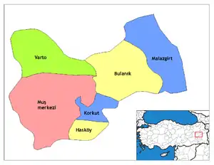
Hasköy, Muş
Hasköy (Armenian: Խասգեղ, Kurdish: Dêrxas[3]) is a town and district of Muş Province in the Eastern Anatolia region of present-day Turkey. The mayor is Mürsel Özen (AKP).
Hasköy
Խասգեղ Khaskyugh | |
|---|---|
 Hasköy | |
| Coordinates: 38°40′56″N 41°41′22″E | |
| Country | |
| Province | Muş |
| Government | |
| • Mayor | Mürsel Özen (AKP) |
| • Kaymakam | Nilüfer Canat Sürekli |
| Area | |
| • District | 379.02 km2 (146.34 sq mi) |
| Elevation | 1,850 m (6,070 ft) |
| Population (2012)[2] | |
| • Urban | 12,822 |
| • District | 27,613 |
| • District density | 73/km2 (190/sq mi) |
| Post code | 497xx |
| Website | www.haskoy.bel.tr |
History
Founded in IIIth century A.D. as Armenian village of Khasgegh Arm: Խասգեղ in Tarawn district of Turuberan province of Arshacid Armenia.
Before the Armenian genocide Khasgegh was an Armenian populated village of Bitlis Province of Ottoman Empire.[4] At the turn of the 20th century photographic records indicate that the town was a cluster of mud brick dome shaped huts.[5] The population in At this time the population was recorded as 2358, mainly Armenians. By the eve of the Armenian Genocide at the beginning of World War 1 the population was 450, The town had three churches the Saint Yerortoutiun, Sdepanos and Talileos church's.
References
- "Area of regions (including lakes), km²". Regional Statistics Database. Turkish Statistical Institute. 2002. Retrieved 2013-03-05.
- "Population of province/district centers and towns/villages by districts - 2012". Address Based Population Registration System (ABPRS) Database. Turkish Statistical Institute. Retrieved 2013-02-27.
- Adem Avcıkıran (2009). Kürtçe Anamnez Anamneza bi Kurmancî (PDF) (in Turkish and Kurdish). p. 56. Retrieved 17 December 2019.
- Map by Robert H. Hewsen, Armenian SSR Atlas, Yerevan – Moscow, 1961
- Khaskyugh, Moush district (Source: [H. F. B. Lynch| H.F.B.] Lynch, Armenia. Travels and Studies, Vol. II, London, 1901)
