Grigneuseville
Grigneuseville is a commune in the Seine-Maritime department in the Normandy region in northern France.
Grigneuseville | |
|---|---|
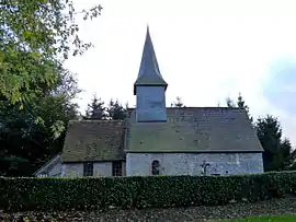 The chapel of Louvetot, in Grigneuseville | |
Location of Grigneuseville 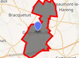
| |
 Grigneuseville  Grigneuseville | |
| Coordinates: 49°39′16″N 1°11′25″E | |
| Country | France |
| Region | Normandy |
| Department | Seine-Maritime |
| Arrondissement | Rouen |
| Canton | Neufchâtel-en-Bray |
| Intercommunality | Bosc d'Eawy |
| Government | |
| • Mayor (2020–2026) | Patrick Vallée |
| Area 1 | 7.59 km2 (2.93 sq mi) |
| Population (2017-01-01)[1] | 368 |
| • Density | 48/km2 (130/sq mi) |
| Time zone | UTC+01:00 (CET) |
| • Summer (DST) | UTC+02:00 (CEST) |
| INSEE/Postal code | 76328 /76850 |
| Elevation | 148–172 m (486–564 ft) (avg. 165 m or 541 ft) |
| 1 French Land Register data, which excludes lakes, ponds, glaciers > 1 km2 (0.386 sq mi or 247 acres) and river estuaries. | |
Geography
A farming village situated in the Pays de Caux, some 24 miles (39 km) south of Dieppe at the junction of the D225, D96 and D151 roads. The A29 autoroute passes through the territory of the commune.
Population
| Year | 1962 | 1968 | 1975 | 1982 | 1990 | 1999 | 2006 |
|---|---|---|---|---|---|---|---|
| Population | 173 | 217 | 183 | 206 | 308 | 327 | 319 |
| From the year 1962 on: No double counting—residents of multiple communes (e.g. students and military personnel) are counted only once. | |||||||
Places of interest
- The church of St.Pierre, dating from the sixteenth century.
- The thirteenth century chapel of St.Madeleine.
- The château d'Haucourt.
References
- "Populations légales 2017". INSEE. Retrieved 6 January 2020.
| Wikimedia Commons has media related to Grigneuseville. |
| Authority control |
|---|
This article is issued from Wikipedia. The text is licensed under Creative Commons - Attribution - Sharealike. Additional terms may apply for the media files.