February 14–15, 2015 North American blizzard
The February 14–15, 2015 North American blizzard was a potent blizzard occurred in the Northeast United States. The storm dropped up to 25 inches (64 cm) of snow in the regions already hit hard with snow from the past 2 weeks. The storm system also brought some of the most coldest temperatures to the Northeast in its wake.
Category 1 "Notable" (RSI: 1.14) | |
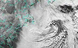
 The winter storm off the New England coast on February 15. | |
| Type | Winter storm Blizzard Extratropical cyclone |
|---|---|
| Formed | February 12, 2015 |
| Dissipated | February 17, 2015 |
| Lowest pressure | 958 mb (28.29 inHg) |
| Maximum snowfall or ice accretion | 27.4 in (70 cm) in Robbinston, Maine[1] |
| Power outages | 200,000 |
| Casualties | 6 fatalities |
| Areas affected | Northeast United States, New England, Canada (partial) |
Part of the 2014–15 North American winter | |
Meteorological history
The storm developed in a similar fashion to how the previous blizzard originated. On February 14, a clipper system moved off the East Coast and began to intensify rapidly. By midnight, it had gained most of the required criteria to meet blizzard conditions in eastern New England. As the system moved northeast on February 15, a persistent band of heavy snow from the winter storm set up near Boston, resulting in some snowfall rates of 2 inches (51 mm) per hour in the snowband. The system continued to intensify even after the storm had ended, with its pressure dropping to 958 millibars (28.3 inHg) by midnight February 16. The storm was then absorbed by another cyclone on February 17.
Aftermath and cold wave
The associated cold wave brought the coldest air recorded over portions of the eastern Great Lakes in decades on February 15, and possibly over the entire forecast record.[2] Well below normal temperatures covered a large portion of the eastern United States and were expected to stay in place, with only slight moderation, through the rest of the month.[3] Through February 21, primarily on February 16 and February 20, over 600 record low temperatures were recorded in the eastern U.S., including all-time record lows and record lows for February.[4] As of February 15, Lake Erie had 94 percent ice cover[5] while Lake Superior and Lake Huron were over 80 percent covered, and Lakes Michigan and Ontario were between 50 and 60 percent iced over.[6]
Snowfall reports
This is a list of the largest snowfall reports by state impacted by the storm.
- 22 inches (56 cm) in Acushnet and Ipswich
- 25.4 inches (65 cm) near Robbinston
- 9 inches (23 cm) in Staffordville
- 9 inches (23 cm) in Oakland
- 8.5 inches (22 cm) near Zeeland
- 20 inches (51 cm) near Seabrook
- 7 inches (18 cm) in Red Bank
- 12 inches (30 cm) in Cape Vincent
- 8 inches (20 cm) in Shaker Heights
- 6 inches (15 cm) in Chandlers Valley
- 14 inches (36 cm) in Warren
- 7.5 inches (19 cm) in Woodford
- 6 inches (15 cm) in Quinwood
See also
- January 2015 North American blizzard
- 2014-15 North American winter
References
- "Winter Storm Neptune: Blowing Snow, Brutal Wind Chills in Wake of New England Blizzard". Weather.com. Retrieved 2016-02-23.
- "Arctic Valentine's blast won't warm the heart". Business First. February 13, 2015. Retrieved February 13, 2015.
- Paul, Don (February 5, 2015). Why it's so gosh darned cold and why it will stay that way for some time to come Archived 2015-09-07 at the Wayback Machine. WIVB-TV. Retrieved February 15, 2015.
- "Siberian Express Grips Midwest, Northeast, South; Four Cities Set All-Time Record Lows". The Weather Channel. February 21, 2015. Retrieved February 21, 2015.
- "Frozen Over: Lake Erie 94 Percent Covered in Ice". NBC News. February 15, 2015. Retrieved February 19, 2015.
- Wagner, Meg (February 17, 2015). "See it: Great Lakes freeze over; Lake Erie nearly 100% covered in ice". New York Daily News. Retrieved February 19, 2015.