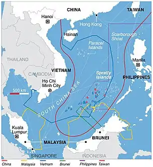
Exclusive economic zone of the Philippines
The Philippines has an exclusive economic zone that covers 2,263,816 km2 (874,064 sq mi). It claims an EEZ of 200 nautical miles (370 km) from its shores.[1] This is due to the 7,641 islands comprising the Philippine Archipelago.[2] The total land area, including inland bodies of water, of the Philippines is 300,000 km2 (120,000 sq mi).[3][4] It has the fifth longest coastline in the world with 36,289 kilometers (22,549 mi).[5][6] The coordinates are between 116° 40', and 126° 34' E longitude and 4° 40' and 21° 10' N latitude. It is bordered by the Philippine Sea[7] to the east and north, the South China Sea[8] to the west, and the Celebes Sea[9] to the south.

Disputes

The Philippines has territorial disputes in the South China Sea mainly with the People's Republic of China. Nearly the whole South China Sea is claimed by China with the nine-dash line. This line cuts half of the Philippine's EEZ. In 2011, former Philippine President Benigno Aquino III said "China's nine-dash line territorial claim over the entire South China Sea is against international laws, particularly the United Nations Convention of the Laws of the Sea (UNCLOS)".[10] In 2013, China began building artificial islands and military bases on reefs in the Spratly Islands and on Scarborough Shoal which it seized in 2012. As of 2019, China controls 20 outposts in the Paracel Islands and 7 in the Spratlys.[11]
On June 12, 2019 a Chinese vessel collided and sank an anchored Philippine fishing boat (F/B Gem-Ver 1) near Recto Bank in the South China Sea. The Chinese vessel didn't save the 22 Filipino fishermen on-board according to the Philippine's Department of National Defense. A couple of minutes later they were rescued by a Vietnamese fishing boat. The Armed Forces of the Philippines said the collision was 'far from accidental.'[12]
References
- Exclusive Economic Zones – Sea Around Us Project – Fisheries, Ecosystems & Biodiversity – Data and Visualization.
- "Namria discovers 400 to 500 new islands in PHL archipelago".
- "Philippine Population Density (Based on the 2015 Census of Population)". September 1, 2016.
- "World Development Indicators - DataBank". databank.worldbank.org.
- "General Information". March 9, 2009. Archived from the original on March 9, 2009. Retrieved September 21, 2014.. (older version – as it existed in 2009 – during the presidency of Gloria Macapagal Arroyo), The Official Government Portal of the Republic of the Philippines Archived September 30, 2007, at the Wayback Machine.
- Central Intelligence Agency. (2009). "Field Listing :: Coastline". Washington, D.C.: Author. Retrieved 2009-11-07.
- Philippine Sea, encarta.msn.com Archived October 31, 2009, at WebCite (archived from the original Archived August 20, 2009, at the Wayback Machine on August 20, 2009).
- "U.S. report details rich resources in South China Sea." (archived from the original on 2013-02-133)
- C.Michael Hogan. 2011. "Celebes Sea". Encyclopedia of Earth. Eds. P. Saundry & C.J. Cleveland. National Council for Science and the Environment. Washington, DC
- Bengco, Regina (2 June 2011). "Aquino mulls UN protest on Spratlys". Maritime Security Asia. Archived from the original on 14 January 2013.
- "China Island Tracker". Asia Maritime Transparency Initiative. Retrieved 2019-05-30.
- "AFP: Chinese vessel's sinking of PH boat 'far from accidental'". June 12, 2019. Archived from the original on June 14, 2019. Retrieved August 3, 2019.