Exclusive economic zone of Indonesia
Indonesia has the sixth-largest exclusive economic zone (Indonesian: Zona Ekonomi Eksklusif, ZEE) in the world with 6,159,032 km2 (2,378,016 sq mi). It claims an EEZ of 200 nautical miles (370 km) from its shores. This is due to the 13,466 islands of the Indonesian archipelago.[1] It has the 3rd largest coastline of 54,720 km (34,000 mi). It is located in Southeast Asia between the Indian Ocean and the Pacific Ocean.
Geography
Indonesia is the largest island country in the world. The total land area is 1,904,569 square kilometres (735,358 sq mi), Including 93,000 square kilometres (35,908 sq mi) of inland seas (straits, bays, and other bodies of water).[2] The total land and sea area (including the EEZ) of Indonesia is about 7.9 million km2.[3][4]
The five main islands are: Sumatra, Java, Borneo, Sulawesi, and Western New Guinea. There are two major island groups (Nusa Tenggara and the Maluku Islands) and sixty smaller island groups. Borneo is shared with Malaysia and Brunei; Sebatik (located northeast of Borneo) is shared with Malaysia; Timor is shared with East Timor; and New Guinea is shared with Papua New Guinea (east side).
| Territory | km2 | sq mi | Notes |
|---|---|---|---|
| Sumatra | 1 | 0.39 | |
| Java | 1 | 0.39 | |
| Sulawesi | 1 | 0.39 | |
| Western New Guinea | 1 | 0.39 | |
| Nusa Tenggara | 1 | 0.39 | |
| Maluku Islands | 1 | 0.39 | |
| Total | 6,159,032 | 3,827,045 |
Disputes

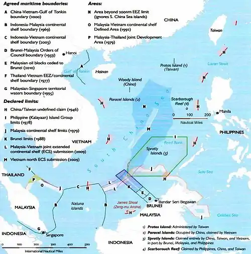
Parts of China's Nine-Dash Line overlap Indonesia's exclusive economic zone near the Natuna islands. Indonesia believes China's claim over parts of the Natuna islands has no legal basis. In November 2015, Indonesia's security chief Luhut Panjaitan said Indonesia could take China before an international court if Beijing's claim to the majority of the South China Sea and part of Indonesian territory is not resolved through dialogue.[6]
The Philippines, Vietnam, Malaysia, Brunei and Indonesia have all officially protested over the use of such a line.[7]
On 26 May 2020, Indonesia sent a formal letter to the United Nations which said "Indonesia reiterates that the Nine-Dash line map implying historic rights claim clearly lacks international legal basis and is tantamount to upsetting UNCLOS 1982," “As a State Party to UNCLOS 1982, Indonesia has consistently called for the full compliance toward international law, including UNCLOS 1982. Indonesia hereby declares that it is not bound by any claims made in contravention to international law, including UNCLOS 1982,"[8]
See also
References
- "Hanya ada 13.466 Pulau di Indonesia". National Geographic Indonesia (in Indonesian). 8 February 2012.
- "Island Countries Of The World". WorldAtlas.com. Archived from the original on 7 December 2017. Retrieved 10 August 2019.
- Faure, Michael G. (2006). Prevention and Compensation of Marine Pollution Damage: Recent Developments in Europe, China and the US. Kluwer Law International. ISBN 9789041123381.
- Frederick, William H.; Worden, Robert L. (2011). Indonesia: A Country Study. Government Printing Office. ISBN 9780844407906.
- "Sea Around Us – Fisheries, Ecosystems and Biodiversity". Retrieved 1 April 2017.
- "Indonesia says could also take China to court over South China Sea". Reuters. 11 November 2015.
- Esplanada, Jerry E. (15 April 2011). "PH runs to UN to protest China's '9-dash line' Spratlys claim".
- "In Letter to UN Chief, Indonesia Takes Stand on South China Sea". Radio Free Asia. 28 May 2020.
