Effects of Hurricane Isaac in Florida
The Effects of Hurricane Isaac in Florida were severe local flooding in South Florida and tornadoes in the central and northern portions of the state in August 2012. Hurricane Isaac formed from a tropical wave while located east of the Lesser Antilles on August 21, 2012. The storm moved westward, crossed through the Leeward Islands, and entered the Caribbean Sea on August 22. Isaac initially struggled to intensify and defied predictions of it strengthening into a hurricane. The storm made its first landfall in Haiti as a midgrade tropical storm prior to making a second one in Cuba later that day. It remained somewhat disorganized while moving through the Straits of Florida and passed near the Florida Keys on August 27. The storm threatened to strike the Tampa Bay Area during the 2012 Republican National Convention and move ashore in the Florida Panhandle as a major hurricane.[1] However, it continued northwestward and avoided landfall in the state. The storm finally became a hurricane late on August 28. Isaac made two landfalls in Louisiana on August 29, the first near the mouth of the Mississippi River and the other near Port Fourchon. The storm steadily weakened and eventually dissipated over Missouri on September 1.
| Tropical storm (SSHWS/NWS) | |
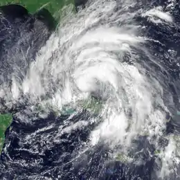 Tropical Storm Isaac approaching the Florida Keys on August 26, 2012 | |
| Winds | 1-minute sustained: 60 mph (95 km/h) |
|---|---|
| Pressure | 990 mbar (hPa); 29.23 inHg |
| Fatalities | 2 indirect |
| Damage | $91.45 million (2012 USD) |
| Areas affected | Florida |
| Part of the 2012 Atlantic hurricane season | |
Despite passing closest to the Florida Keys, impact was minimal, limited to tropical storm-force winds and light rainfall. The outer bands of Isaac produced heavy precipitation further north, especially in Palm Beach, St. Lucie and Indian River counties. In the former, the resultant flooding left numerous residents in Royal Palm Beach and Loxahatchee isolated. There was extensive street flooding, and water entered a few houses. Damage in Palm Beach County alone was nearly $71.6 million (2012 USD). Inland flooding was also reported in several other counties, though losses were generally minor. A tornado in Indian River County damaged 118 mobile homes and 15 single family homes. Further north in Central Florida and the Panhandle, the storm spawned four other tornadoes. Tides along the Gulf Coast of Florida caused erosion and coastal flooding in Bay, Collier, Franklin, Gulf, and Wakulla counties. Though winds caused little damage, around 113,000 customers were left without electricity in South Florida. The storm resulted in two indirect fatalities, both caused by vehicles driving on slick roads in Palm Beach and Okeechobee counties. Throughout the state, damage reached approximately $91.45 million.
Background
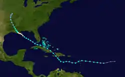
Hurricane Isaac originated from a tropical wave that moved off the western coast of Africa on August 17. Moving generally westward, the low-pressure area initially did not have a well-defined center until three days later. Convection associated with the system organized and intensified, and the tropical wave quickly strengthened into a tropical depression. In favorable conditions, the depression was upgraded to Tropical Storm Isaac by the National Hurricane Center (NHC) on August 21. Quickly accelerating westward due to a subtropical ridge located to the northwest, Isaac later moved past the Lesser Antilles between Guadeloupe and Dominica by August 23, where it caused numerous mudslides and power outages. Maintaining tropical storm intensity, Isaac later made its first landfall on the southern coast of Haiti early on August 25 as a result of southeast flow. There, the storm directly killed 24 people, worsening conditions still remaining after the 2010 Haiti earthquake.[2]
Isaac began to curve northwestward due to its location between a large deep-layer low pressure area in the northwestern Caribbean Sea and a mid-tropospheric ridge over the western Atlantic. After briefly moving into the Gulf of Gonâve, the tropical storm made a second landfall near Cajobabo, Guantánamo, in Cuba at 1500 UTC later on August 25, where damages were comparatively less severe than in Haiti. The storm paralleled the northern coast of the island prior to making a close pass of Key West, Florida, where it caused minor flood damage across the Florida Keys and South Florida upon entry into the Gulf of Mexico. The threat of tropical cyclone impacts in Tampa forced the postponing of the 2012 Republican National Convention. In the gulf, the tropical storm curved to the northwest and attained hurricane strength on August 27 near the southern Louisiana coast. Another ridge of high pressure caused Isaac to move towards the west and slow down as it made two landfalls on the state. Once it moved inland, the hurricane weakened before dissipating over Missouri on September 1.[2]
Preparations

At 2100 UTC on August 24, a tropical storm watch was issued for all of Florida south of the Jupiter Inlet on the east coast and south of Bonita Springs on the west coast; it also included Lake Okeechobee and the Florida Keys. Early on the next day, the tropical storm watch was upgraded to a warning, while the Florida Keys and the mainland from Ocean Reef to Bonita Springs were placed under a hurricane watch. Further north, a tropical storm watch was issued from the Jupiter Inlet to the Sebastian Inlet. Later on August 25, the hurricane watch was switched to a warning, while a separate hurricane watch was issued from Golden Beach southward. At 1500 UTC on August 25, the tropical storm warning was extended northward to Sebastian Inlet. In addition, a tropical storm watch was issued further north from Sebastian Inlet to Flagler Beach on the east coast and Bonita Springs to Tarpon Springs on the west coast. About six hours later, the tropical storm watch along the west coast of Florida was extended northward to the mouth of the Suwannee River on August 25. The tropical storm watch, which now stretched from Bonita Springs to Tarpon Springs, was extended to Indian Pass on August 26. Simultaneously, a hurricane watch was issued from the mouth of the Mississippi River in Louisiana to Indian Pass, Florida.[2]
After Isaac crossed the Florida Keys on August 26, the hurricane warning was downgraded to a tropical storm warning, and the tropical storm watch from Sebastian Inlet to Flagler Beach was discontinued. Simultaneously, the hurricane watch on the Gulf Coast of the United States was upgraded to a hurricane warning along the portion from Morgan City, Louisiana, to Destin, Florida. Additionally, the tropical storm warning was discontinued from the mouth of the Suwannee River to Tarpon Springs. Early on August 27, the tropical storm warning on the east coast of Florida was discontinued for areas lying north of the Jupiter Inlet. Six hours later, the tropical storm warning on the east coast of Florida was lifted from the Jupiter Inlet southward to Ocean Reef, including Lake Okeechobee. At 1500 UTC, all of the remaining watches and warnings for South Florida were cancelled. On August 28, the tropical storm warning in the Florida Panhandle was discontinued for areas east of Destin. By 1500 UTC on August 29, all tropical storm and hurricane watches and warnings were no longer in effect for the state of Florida.[2]
During the week of August 27, the 2012 Republican National Convention was held in Tampa, Florida. Isaac threatened to force the cancellation or postponement of the convention; there was also potential to move the event's location. According to the Republican National Convention spokesman James Davis, officials had been coordinating with the United States Secret Service, should the 50,000 politicians, delegates, and reporters require evacuation.[3][4] The Republican National Convention was pushed to August 28, with the storms threatening the coast of Tampa.[5] Chairman of the Republican National Convention Reince Priebus announced on August 25 that the convention would only convene for a short amount of time on August 27 and "immediately recess until Tuesday afternoon, August 28". At the same time, Governor of Florida Rick Scott announced he would not be attending the convention, together with Governor of Alabama Robert J. Bentley.[6] On August 25, Governor Scott declared a state of emergency for the state of Florida ahead of Tropical Storm Isaac. Amtrak suspended the Silver Meteor and Silver Star train service from Orlando to Miami on Sunday, August 26.[7] In Miami-Dade County, evacuations were ordered for residents living in mobile homes. Additionally, the bridges across the Port of Miami were closed during the height of Isaac.[8] Orange juice prices increased due to the threat of the storm in Florida, which produces more than 75 percent of orange crops in the United States.[9]
The Florida Division of Emergency Management was put into partial activation, and Florida Power & Light brought in at least 4,300 workers to help with expected power outages. Key West International Airport suspended all flights in preparation of Isaac, while all cruises and many theme parks were delayed. The United States Coast Guard activated hurricane condition "whiskey", restricting the transportation of watercraft until the storm passed. In South Florida, specifically in Monroe County, many schools were used as shelters. In Miami-Dade County, all public schools and universities – including Florida International University and the University of Miami – cancelled classes. While the airport in the county remained open, it cancelled hundreds of flights and delayed many others. As the storm passed, regular services became available once again. Across the remainder of the state, especially in coastal counties, most schools and government buildings were closed. In Escambia County, a mandatory evacuation was ordered for zones A, B, and C. Many shelters were opened for those who had nowhere to go, and all county schools were shut down. At Naval Air Station Pensacola, many planes were either evacuated from the base or placed into secure hangars. Farther east in Santa Rosa County, a mandatory evacuation was also ordered for zones A, B, and C, including all mobile home parks, campgrounds, low-lying areas, and RV parks. In Walton County, special needs and general shelters were opened to the public, and all schools and government offices were to be shut down throughout the duration of the storm. The Clyde B. Wells Bridge was also shut down in anticipation of tropical storm-force winds.[10]
Impact
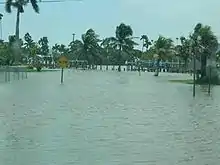
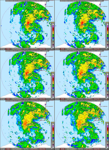
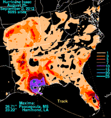
The storm impacted nearly all of Florida, despite not making landfall in the state. Due to the weak intensity and path offshore, damage was caused primarily by flooding, rather than winds. Persistent rainbands brought heavy precipitation to much of east-central and southeast Florida. In central Palm Beach County, the highest observed total precipitation was 15.86 inches (403 mm), though radars estimated that as much as 18 to 20 inches (460 to 510 mm) fell in some areas. The resultant flooding left entire neighborhoods isolated and caused damage to homes, businesses, and roads in Palm Beach County.[2] Other areas, such as Broward, Indian River, Martin, Miami-Dade, and St. Lucie counties, were also impacted by flooding, albeit less severely.[11]
Tides along the Gulf Coast of Florida caused erosion and coastal flooding in Bay, Collier, Franklin, Gulf, and Wakulla counties. Though winds caused little damage, around 113,000 customers were left without electricity in South Florida alone.[11] Further north in Central Florida and the Panhandle, Isaac spawned five tornadoes, one each in Hillsborough, Holmes, Indian River, Jackson, and Osceola counties.[12][13][14] All of them ranked as only F0 on the Fujita scale. The worst twister occurred in Indian River County, damaging 133 buildings, most of which were mobile homes.[14] Throughout the state, two indirect fatalities were reported and losses reached approximately $91.54 million.[8][11][15][16][17][18]
Southern Florida
Despite the Florida Keys being the closest to the path of the storm, effects there were minimal. In Molasses Reef, sustained winds reached 44 mph (71 km/h), while winds peaked at 41 mph (66 km/h) in Sombrero Key.[19] Rainfall in the Florida Keys was light, peaking at 1.61 inches (41 mm) at the National Weather Service Office in Key West. Winds were stronger in Miami-Dade County, reaching 60 mph (97 km/h) at the Atlantic Oceanographic and Meteorological Laboratory (AOML) headquarters in Virginia Key.[2] Many trees and power lines were downed throughout the county, with an estimated 33,000 residences experiencing power outages.[17] Tides reaching up to 6 feet (1.8 m) caused major beach erosion and minor coastal flooding in Naples. Between Everglades City and Chokoloskee, up to 3 feet (0.91 m) of tidal inundation occurred, leaving roads flooded, stranding some people.[8] In Goodland, water entered a few homes but was mainly confined to streets, yards, and marinas. Less than 2,000 people were left without electricity in Collier County.[17] Damage within that county was estimated to have reached $6 million. Throughout southeastern Florida, 113,000 people were left without electricity.[8]
Heavy rainfall fell in portions of Broward County, peaking at 11.21 inches (285 mm) at the intersection of State Road 997 and Interstate 75 near Weston. Other significant precipitation totals include 10.86 inches (276 mm) in Miramar, and 10.41 in (264 mm) in Coral Springs, with 7 to 10 in (180 to 250 mm) reported at numerous other locations in the county.[17] Moderate to severe flooding occurred over parts of northern Broward County. In Lauderhill, canals overflowed their banks and streets were flooded for a few days. Additionally, a few homes sustained minor water damage.[11] Water also entered a few homes and businesses in Tamarac.[17] Standing water also forced the closure of a few on-ramps to the Sawgrass Expressway.[11] Losses in Broward County reached $1 million.[17]
Palm Beach County
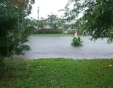
The outer bands produced relatively strong winds in Palm Beach County. Wind gusts were estimated to have reached 60 mph (97 km/h) in Tequesta, where the shutters were ripped from a life guard stand and also moved the structure about 3 feet (0.91 m) from its original location. Additionally, winds in the area blew significant amounts of sand away, exposing rocks and creating 8–10-foot (2.4–3.0 m) drops. Slightly further south, waves of 8–10 feet (2.4–3.0 m) pounded the beaches of Jupiter, though only minimal beach erosion was reported. Nonetheless, hundreds of sea turtle nests were swept away, though 100 hatchlings were brought to the Loggerhead Marinelife Center in Juno Beach.[20] In Palm Beach County, the outer bands dropped significant amounts of rainfall, with radar estimates as high as 20 inches (510 mm) in some areas. The highest observed precipitation total, measured in that vicinity, was 15.86 inches (403 mm) at Lion Country Safari in Loxahatchee, while 13.754 inches (349.4 mm) fell in Boynton Beach, 13.1 inches (330 mm) fell in Greenacres and 12.55 inches (319 mm) fell in Wellington. Nearly all of the eastern half of Palm Beach County experienced at least 10 inches (250 mm) of precipitation.[2][21]
Due to heavy rainfall, widespread flooding was reported, especially in the central and western portions of the county. Whole neighborhoods in The Acreage, Loxahatchee, Royal Palm Beach, and Wellington were left stranded for up to several days.[2] In some areas, flooding was considered the worst since Hurricane Irene in 1999. At the post office in Loxahatchee, the parking lot was flooded, forcing the building to close for several days. A major washout was reported in West Palm Beach at the intersection of State Roads 80 and 882. Also in West Palm Beach, a road collapsed and fire rescue crews quickly closed the road. On State Road 704, a portion of it became inaccessible to low-clearance vehicles.[20] A man died in West Palm Beach after driving through the storm and crashing into a concrete wall along Interstate 95.[22] Several major and minor roads were also inundated by water in Wellington. Additionally, there was flooding at the intersections of Meadow Avenue and Greenview Shores Boulevard, and Indian Mound Road and South Shore Boulevard. Heavy rainfall left several leaking roofs at an apartment complex in Pahokee.[20]
In the southern portion of Palm Beach County, flooding and wind damage was also reported.[20] Residents reported an unconfirmed tornado in Lake Worth. It knocked over some trees and damage a shed and some roofs, as well as cause a few power outages.[23] The entrance to the gated community of Lawrence Grove in Boynton Beach was flooded by about 1 foot (300 mm) of water and passable only by large pickup trucks.[20] In Delray Beach, lightning struck a tree, causing part of it to fall through an awning, break a window, and slice into a house. Streets were littered with small branches and palm fronds in Boca Raton, while low-lying roads and swales were flooded with several inches of water. One small tree was uprooted across the street from City Hall.[20] Initially, schools throughout the county were to remain open.[24] However, in response to flooding, all Palm Beach County schools were closed on August 27 and August 28.[25] Thereafter, all but eight county public schools – located in Loxahatchee and The Acreage – were opened.[26] Damage estimates for Palm Beach County reached $71.59 million, $40 million of which was incurred to the Indian Trail Improvement District.[16]
Central Florida
Precipitation amounts ranging from 4 to 8 inches (100 to 200 mm) were common throughout Okeechobee County. The most significant impacts occurred in the city of Okeechobee and adjacent areas, such as Taylor Creek. Overflowing creeks and canals caused major flood damage to 14 homes, while another 146 had minor water intrusion. Several roads were temporarily closed due to standing water.[11] One indirect fatality occurred along State Road 78 in Okeechobee, after a 62‑year‑old man lost control of his vehicle and crashed.[22] Winds were relatively light, with gusts between 30 and 40 mph (48 and 64 km/h) along the northern shores of Lake Okeechobee. In nearby Martin County, rainfall averaged between 5 and 10 inches (130 and 250 mm). As a result, several roads in the county were temporarily impassable, while water entered one business complex in Palm City. Further north in St. Lucie County, rainfall amounts were similar. Standing water was reported on roads in Fort Pierce, Lakewood Park, Port St. Lucie, and White City.[11]
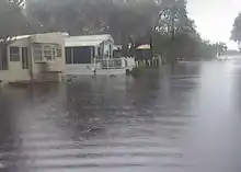
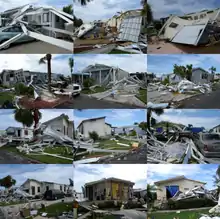
The storm also produced heavy rainfall in Indian River County, with 16.5 in (420 mm) reported in Vero Beach. This was the highest observed precipitation total in the state of Florida during Isaac. Elsewhere in Indian River County, rainfall amounts were generally between 7 and 10 inches (180 and 250 mm).[14] Throughout Indian River County, 27 homes and 2 single–family homes were flooded, while 20 roads were temporarily closed due to standing water.[11] An EF0 tornado touched down in Vero Beach for about two minutes, damaging 118 mobile homes and 15 single family houses.[14] According to Indian River County Emergency Management Coordinator Dale Justice, that tornado caused $850,000 in losses.[18] At the Vero Beach Municipal Airport, sustained winds reached 43 mph (69 km/h).[14] In Highlands County, up to 6 inches (150 mm) of rain forced the closure of a small portion of U.S. Route 98 between Cowhouse Road and County Road 621 in Lorida. The inundation was caused by Arbuckle Creek overflowing and washing a few inches of water on the road.[11]
A damage survey conducted by the National Weather Service indicates that a tornado was spawned near St. Cloud in Osceola County. It destroyed an abandoned mobile home, leaving only a floor attachment to the frame. The tornado moved across a citrus grove, causing damage to trees and shrubs. Thereafter, it removed shingles and broke a window at one residence, while some fences nearby were toppled.[14] Additionally, rainfall amounts ranging from 3 to 6 inches (76 to 152 mm) left several roads impassable. The Myakka River overflowed in Sarasota County, flooding the Ramblers Mobile Home Park. Water rose up to the doorsteps of several units, while parking lots and grassy areas were inundated by water.[11] Due to its weaker and further westward track than initially anticipated, impact in Hillsborough County and the city of Tampa was minimal during the Republican National Convention. On the first day of the convention, August 27, Isaac dropped 2.03 inches (52 mm) of precipitation and brought sustained winds of 21 mph (34 km/h) to Tampa International Airport, with gusts up to 50 mph (80 km/h).[27] A waterspout moved onshore near Tampa, damaging 6 houses in addition to the fences and trees on those properties.[12]
North Florida and Florida Panhandle
Although it passed further west and was weaker than anticipated,[16] the outer bands and fringe of the storm produced light rainfall and two tornadoes in the Florida Panhandle. The first tornado in the region was spawned near Greenwood in Jackson County, but caused no damage. The other tornado touched down near Graceville in Holmes County and ripped off the front porch of a mobile home and downed numerous trees.[13] Rainfall was reported for a 3-day period in Flagler County from August 26 to August 28. In Palm Coast, communities measured between 2 and 3.5 inches (51 and 89 mm) of precipitation. Some minor flooding occurred in parking lots. Gusty winds of 40 to 50 mph (64 to 80 km/h) felled isolated trees in the western part of the county. A few trees were also blown down in Alachua County, one of which fell onto Main Street in Gainesville.[11] Losses in Escambia and Santa Rosa Counties amounted to $10.4 million and $1.2 million respectively.[15]
Some coastal flooding occurred across portions of Bay, Franklin, Gulf, and Wakulla counties due to storm surge. Erosion was most significant in Franklin County, where storm surge was measured at 3.45 feet (1.05 m) in Apalachicola, while tides were 6 to 8 feet (1.8 to 2.4 m) above normal. Water Street in Apalachicola was inundated with over 1 foot (0.30 m) of water in some places. At St. George Island State Park, waves pushed pass the dune line and flooded parking areas. Losses were estimated at about $500,000.[11] In Bay County, storm surge reached 2.5 feet (0.76 m) at Panama City, while tides were 8 to 10 feet (2.4 to 3.0 m) above normal. The depth of inundation along 7th Avenue in Panama City ranged from a few inches to about one foot, while other roads in Lynn Haven and West Bay were also flooded. Tides along the coast of Gulf County flooded a road in Indian Pass and the access road to St. Joseph Peninsula State Park, causing closure of the park. In Wakulla County, minor coastal flooding was reported around St. Marks, with 2 to 4 inches (51 to 102 mm) of water in a few businesses.[11] The area experienced tidal flooding only about two months earlier during Tropical Storm Debby.[28] One vacant home experienced minor water intrusion around the time of highest tide in Shell Point.[15]
Aftermath
Following the storm, Governor of Florida Rick Scott attended a briefing at the South Florida Water Management District before boarding a helicopter to tour flooded areas of Palm Beach County. Scott said, "We've got to take care of everybody's needs but we've got to get our state back to work," and also encouraged tourists to return to the state, especially in Key West, where hotel owners were considering cancelling reservations for Labor Day. A Florida state fund known as Neighbors to the Rescue – with the purpose of distributing money to help recovery efforts for victims of Isaac – was activated by the governor. The area already qualified for small business loans due to a state of emergency and after the Federal Emergency Management Agency (FEMA) reviewed damage assessments, President of the United States Barack Obama considered a disaster declaration.[16] Initially, FEMA denied a disaster declaration. In response, Governor Scott mailed a letter of appeal to FEMA Administrator Craig Fugate.[29] The appeal was accepted, and on October 18, 2012, President Obama issued a disaster declaration for Bay, Collier, Escambia, Franklin, Gulf, Martin, Monroe, Okaloosa, Palm Beach, St. Lucie, and Santa Rosa counties.[30]
See also
References
- Eric Berger (August 27, 2012). "Isaac to hit Gulf coast as a hurricane". Houston Chronicle. Key West, Florida. Retrieved March 31, 2013.
- Robbie J. Berg (January 28, 2013). Tropical Cyclone Report: Hurricane Isaac (PDF). National Hurricane Center (Report). Miami, Florida: National Oceanic and Atmospheric Administration. Retrieved March 14, 2013.
- Katie Glueck (August 22, 2012). "Tampa mayor: Tropical storm Isaac could force cancellation, delay or move". Politico. Retrieved March 19, 2013.
- Alan Gomez; Doyle Rice (August 21, 2012). "Isaac could threaten GOP convention in Tampa". Tucson Citizen. Washington, D.C. USA Today. Retrieved March 14, 2013.
- David Grant (August 25, 2012). "Hurricane Isaac delays start of Republican National Convention in Tampa". The Christian Science Monitor. Retrieved March 14, 2013.
- "Gov. Scott withdraws from RNC activities ahead of Isaac". Bay News 9. St. Petersburg, Florida. August 25, 2012. Retrieved March 14, 2013.
- "Amtrak Silver Service Impacted by Approaching Tropical Storm Isaac". Amtrak. Washington, D.C. Archived from the original on August 29, 2012. Retrieved August 26, 2012.
- Tropical Storm Isaac August 26–27, 2012. National Weather Service Miami, Florida (Report). National Oceanic and Atmospheric Administration. October 15, 2012. Retrieved October 30, 2012.
- Tom Brown (August 22, 2012). "Storm Isaac threatens Caribbean, U.S. Republican Convention". Reuters. Miami, Florida. Retrieved August 22, 2012.
- "Florida County-by-County Preparations". The Weather Channel. The Weather Channel. August 27, 2012. Retrieved March 15, 2013.
- Rhonda Herndon (2012). Storm Data and Unusual Weather Phenomena: August 2012 (PDF). National Climatic Data Center (Report). Asheville, North Carolina: National Oceanic and Atmospheric Administration. pp. 78–80, 85, 91, 94, 94. Retrieved March 14, 2013.
- 20120827's Storm Reports (1200 UTC − 1159 UTC). Storm Prediction Center (Report). Norman, Oklahoma: National Oceanic and Atmospheric Administration. September 6, 2012. Retrieved October 17, 2012.
- 20120829's Storm Reports (1200 UTC − 1159 UTC). Storm Prediction Center (Report). Norman, Oklahoma: National Oceanic and Atmospheric Administration. September 5, 2012. Retrieved September 5, 2012.
- PG (August 29, 2012). Tropical Cyclone Isaac brings flooding rainfall and a tornado to East Central Florida (PDF) (Report). Melbourne, Florida National Weather Service. Archived from the original (PDF) on August 30, 2012. Retrieved August 30, 2012.
- "FEMA Denies Hurricane Isaac Claims By Escambia, Santa Rosa". North Escambia. Walnut Hill, Florida. September 21, 2012. Retrieved October 4, 2012.
- Eliot Kleinberg; Jennifer Sorentrue (August 29, 2012). "Gov. Scott tours flooded Palm Beach County; damage set at $72 million". Palm Beach Post. Retrieved August 29, 2012.
- Robert Molleda (August 31, 2012). Post Tropical Cyclone Report...Tropical Storm Isaac (PDF). National Weather Service Miami, Florida (Report). Miami, FL: NOAA. Retrieved October 30, 2012.
- Henry Stephens (September 14, 2012). "No FEMA money coming to Indian River County Isaac tornado victims". TCPalm. Retrieved October 31, 2012.
- Jeff Masters (August 26, 2012). "Isaac lashing the Keys; an eyewall is building". Weather Underground. Archived from the original on August 29, 2012. Retrieved October 31, 2012.
- "80,000 in South Florida still without power". Palm Beach Post. August 27, 2012. Retrieved August 29, 2012.
- Robert Molleda and Ross (August 28, 2012). Public Information Statement. National Weather Service Miami, Florida (Report). National Oceanic and Atmospheric Administration. Archived from the original on August 30, 2012. Retrieved August 30, 2012.
- Sonja Isger (August 27, 2012). "As residents cope with major flooding, more rain threatens". Palm Beach Post. Retrieved August 29, 2012.
- "Tropical Storm Isaac: Wind damage in Lake Worth". WPTV. August 28, 2012. Archived from the original on February 3, 2013. Retrieved March 15, 2013.
- David Fleshler; Andy Reid (August 25, 2012). "Palm Beach County prepares for Isaac". Sun-Sentinel. Retrieved March 15, 2013.
- Andy Reid, Ed Komenda, and Mike Clary (August 28, 2012). "Flood water starting to recede in Palm Beach County". Sun-Sentinel. Retrieved March 15, 2013.CS1 maint: multiple names: authors list (link)
- "8 Palm Beach County schools to remain closed on Thursday". Sun-Sentinel. August 29, 2012. Retrieved March 15, 2013.
- History for Tampa Knight Airport, FL (Report). Weather Underground. August 27, 2012. Retrieved October 17, 2012.
- Todd B. Kimberlain (January 7, 2013). Tropical Cyclone Report: Tropical Storm Debby (PDF). National Hurricane Center (Report). Miami, Florida: National Oceanic and Atmospheric Administration. Retrieved January 7, 2013.
- "Disaster declaration for Florida denied after Isaac causes damage, governor appeals". WPTV. September 20, 2012. Archived from the original on March 10, 2013. Retrieved October 30, 2012.
- "President Declares Disaster for Florida". Federal Emergency Management Agency. Washington, D.C. United States Department of Homeland Security. October 18, 2012. Retrieved October 30, 2012.
External links
| Wikimedia Commons has media related to Hurricane Isaac (2012). |