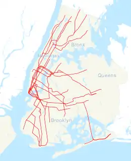
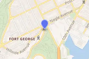
Dyckman Street station (IRT Broadway–Seventh Avenue Line)
Dyckman Street (pronounced DIKE-man) is a station on the IRT Broadway–Seventh Avenue Line of the New York City Subway. Located roughly at the intersection of Dyckman Street and Nagle Avenue in Inwood, Manhattan, it is served by the 1 train at all times.
Dyckman Street | ||||||||||||||||||||||||||||||||||||||||||||||||||||||||||||||||||||||||||||||||||||||||||||||||
|---|---|---|---|---|---|---|---|---|---|---|---|---|---|---|---|---|---|---|---|---|---|---|---|---|---|---|---|---|---|---|---|---|---|---|---|---|---|---|---|---|---|---|---|---|---|---|---|---|---|---|---|---|---|---|---|---|---|---|---|---|---|---|---|---|---|---|---|---|---|---|---|---|---|---|---|---|---|---|---|---|---|---|---|---|---|---|---|---|---|---|---|---|---|---|---|---|
.JPG.webp) Station platforms | ||||||||||||||||||||||||||||||||||||||||||||||||||||||||||||||||||||||||||||||||||||||||||||||||
| Station statistics | ||||||||||||||||||||||||||||||||||||||||||||||||||||||||||||||||||||||||||||||||||||||||||||||||
| Address | Dyckman Street & Nagle Avenue New York, NY 10034 | |||||||||||||||||||||||||||||||||||||||||||||||||||||||||||||||||||||||||||||||||||||||||||||||
| Borough | Manhattan | |||||||||||||||||||||||||||||||||||||||||||||||||||||||||||||||||||||||||||||||||||||||||||||||
| Locale | Inwood | |||||||||||||||||||||||||||||||||||||||||||||||||||||||||||||||||||||||||||||||||||||||||||||||
| Coordinates | 40.861°N 73.925°W | |||||||||||||||||||||||||||||||||||||||||||||||||||||||||||||||||||||||||||||||||||||||||||||||
| Division | A (IRT) | |||||||||||||||||||||||||||||||||||||||||||||||||||||||||||||||||||||||||||||||||||||||||||||||
| Line | IRT Broadway–Seventh Avenue Line | |||||||||||||||||||||||||||||||||||||||||||||||||||||||||||||||||||||||||||||||||||||||||||||||
| Services | 1 | |||||||||||||||||||||||||||||||||||||||||||||||||||||||||||||||||||||||||||||||||||||||||||||||
| Transit | ||||||||||||||||||||||||||||||||||||||||||||||||||||||||||||||||||||||||||||||||||||||||||||||||
| Structure | Embankment / At-Grade | |||||||||||||||||||||||||||||||||||||||||||||||||||||||||||||||||||||||||||||||||||||||||||||||
| Platforms | 2 side platforms | |||||||||||||||||||||||||||||||||||||||||||||||||||||||||||||||||||||||||||||||||||||||||||||||
| Tracks | 2 | |||||||||||||||||||||||||||||||||||||||||||||||||||||||||||||||||||||||||||||||||||||||||||||||
| Other information | ||||||||||||||||||||||||||||||||||||||||||||||||||||||||||||||||||||||||||||||||||||||||||||||||
| Opened | March 12, 1906 | |||||||||||||||||||||||||||||||||||||||||||||||||||||||||||||||||||||||||||||||||||||||||||||||
| Station code | 299[1] | |||||||||||||||||||||||||||||||||||||||||||||||||||||||||||||||||||||||||||||||||||||||||||||||
| Accessible | ||||||||||||||||||||||||||||||||||||||||||||||||||||||||||||||||||||||||||||||||||||||||||||||||
| Opposite- direction transfer | Yes | |||||||||||||||||||||||||||||||||||||||||||||||||||||||||||||||||||||||||||||||||||||||||||||||
| Traffic | ||||||||||||||||||||||||||||||||||||||||||||||||||||||||||||||||||||||||||||||||||||||||||||||||
| 2019 | 2,079,656[2] | |||||||||||||||||||||||||||||||||||||||||||||||||||||||||||||||||||||||||||||||||||||||||||||||
| Rank | 228 out of 424[2] | |||||||||||||||||||||||||||||||||||||||||||||||||||||||||||||||||||||||||||||||||||||||||||||||
| Station succession | ||||||||||||||||||||||||||||||||||||||||||||||||||||||||||||||||||||||||||||||||||||||||||||||||
| Next north | Van Cortlandt Park–242nd Street (express): no regular service 207th Street (local): 1 | |||||||||||||||||||||||||||||||||||||||||||||||||||||||||||||||||||||||||||||||||||||||||||||||
| Next south | 191st Street: 1 | |||||||||||||||||||||||||||||||||||||||||||||||||||||||||||||||||||||||||||||||||||||||||||||||
| ||||||||||||||||||||||||||||||||||||||||||||||||||||||||||||||||||||||||||||||||||||||||||||||||
| ||||||||||||||||||||||||||||||||||||||||||||||||||||||||||||||||||||||||||||||||||||||||||||||||
| ||||||||||||||||||||||||||||||||||||||||||||||||||||||||||||||||||||||||||||||||||||||||||||||||
| ||||||||||||||||||||||||||||||||||||||||||||||||||||||||||||||||||||||||||||||||||||||||||||||||
Dyckman Street Subway Station (IRT) | ||||||||||||||||||||||||||||||||||||||||||||||||||||||||||||||||||||||||||||||||||||||||||||||||
| MPS | New York City Subway System MPS | |||||||||||||||||||||||||||||||||||||||||||||||||||||||||||||||||||||||||||||||||||||||||||||||
| NRHP reference No. | 04001021[3] | |||||||||||||||||||||||||||||||||||||||||||||||||||||||||||||||||||||||||||||||||||||||||||||||
| Added to NRHP | September 17, 2004 | |||||||||||||||||||||||||||||||||||||||||||||||||||||||||||||||||||||||||||||||||||||||||||||||
Built by the Interborough Rapid Transit Company (IRT), the station opened on March 12, 1906, as part of the first subway. The northbound platform was lengthened in 1910 while the southbound platform was lengthened in 1948. The station house under the platforms was renovated in 1991. The station was renovated in 2014, during which the southbound platform was retrofitted with an elevator to comply with the Americans with Disabilities Act of 1990.
The Dyckman Street station contains two side platforms and two tracks. The platforms contain stairs to the station house at Dyckman Street and Nagle Avenue. While the southbound platform also has an elevator to the station house, making it ADA-accessible, the northbound platform does not, although an elevator to the northbound platform is planned as of 2019. The station is listed on the National Register of Historic Places.
History
Construction and opening
Planning for the city's first subway line dates to the Rapid Transit Act, authorized by the New York State Legislature in 1894.[4]:139–140 The subway plans were drawn up by a team of engineers led by William Barclay Parsons, chief engineer of the Rapid Transit Commission. It called for a subway line from New York City Hall in lower Manhattan to the Upper West Side, where two branches would lead north into the Bronx.[5]:3 A plan was formally adopted in 1897, and legal challenges were resolved near the end of 1899.[4]:148 The Rapid Transit Construction Company, organized by John B. McDonald and funded by August Belmont Jr., signed Contract 1 with the Rapid Transit Commission in February 1900,[6] in which it would construct the subway and maintain a 50-year operating lease from the opening of the line. Belmont incorporated the Interborough Rapid Transit Company (IRT) in April 1902 to operate the subway.[4]:182
The Dyckman Street station was constructed as part of the IRT's West Side Line (now the Broadway–Seventh Avenue Line) north of Hillside Avenue. Work on this section was conducted by E. P. Roberts and Terry & Tench Construction Company, who started building the viaduct on January 19, 1903.[6] The West Side Branch of the first subway was extended northward to a temporary terminus of 221st Street and Broadway on March 12, 1906 with the first open station at Dyckman Street, as the stations at 168th Street, 181st Street, and 191st Street were not yet completed.[7][8][9] This extension was served by shuttle trains operating between 157th Street and 221st Street until May 30, 1906 when express trains began running through to 221st Street.[10] The opening of the first subway line, and particularly the Dyckman Street station, helped contribute to the development of Upper Manhattan.[3]:9
After the initial system was completed in 1908,[11] the station was served by West Side local and express trains. Express trains began at South Ferry in Manhattan or Atlantic Avenue in Brooklyn, and ended at 242nd Street in the Bronx. Local trains ran from City Hall to 242nd Street during rush hours, continuing south from City Hall to South Ferry at other times.[12] In 1918, the Broadway–Seventh Avenue Line opened south of Times Square–42nd Street, thereby dividing the original line into an "H" system. Local trains were sent to South Ferry, while express trains used the new Clark Street Tunnel to Brooklyn.[13]
Station improvements

In 1909, to address overcrowding, the New York Public Service Commission proposed lengthening platforms at stations along the original IRT subway.[14]:168 On January 18, 1910, a modification was made to Contracts 1 and 2 to lengthen station platforms to accommodate ten-car express and six-car local trains. In addition to $1.5 million (equivalent to $41.2 million in 2019) spent on platform lengthening, $500,000 (equivalent to $13,719,643 in 2019) was spent on building additional entrances and exits. It was anticipated that these improvements would increase capacity by 25 percent.[15]:15 The northbound platform at the Dyckman Street station was extended 100 feet (30 m) to the south, with a new retaining wall being constructed.[15]:114 The southbound platform was not lengthened.[15]:106 On January 24, 1911, ten-car express trains began running on the West Side Line.[14]:168[16]
In 1948, platforms on the IRT Broadway–Seventh Avenue Line from 103rd Street to 238th Street were lengthened to 514 feet (157 m) to allow full ten-car express trains to stop at this station. Previously, the station could accommodate six-car local trains, but ten-car trains could not open some of their doors. The platform extensions at these stations were opened in stages. On April 6, 1948, the platform extension at Dyckman Street opened.[17][18] At the same time, the IRT routes were given numbered designations with the introduction of "R-type" rolling stock. The first such fleet, the R12, was put into service in 1948.[19] The Broadway/West Side route to 242nd Street became known as the 1.[20]
In April 1988,[21] the New York City Transit Authority (NYCTA) unveiled plans to speed up service on the Broadway–Seventh Avenue Line through the implementation of a skip-stop service: the 9 train.[22] When skip-stop service started on August 21, 1989, skip-stop service was implemented during rush hours and middays. Dyckman Street was served by the 1 at all times.[23][24][25] On September 4, 1994, midday skip-stop service was discontinued.[26] Skip-stop service ended on May 27, 2005.[27]
The control house was renovated between 1990 and 1991.[3]:4 The station was listed on the National Register of Historic Places on September 17, 2004.[3]
Starting in 2010, the station was renovated as part of a $45 million project.[28] The project included rehabilitation of the tunnel portal, realignment and rehabilitation of the platforms and installation of new cast iron lighting fixtures.[29][30] Initially, no elevators were planned for the Dyckman Street station because it was not on the MTA's list of "key stations" that would receive disabled access under the Americans with Disabilities Act of 1990 (ADA).[28] The United Spinal Association subsequently filed a lawsuit to stop the project because it did not include elevators. The suit was settled in 2011, and an elevator to the southbound platform was built.[31][32] No elevator was added to the northbound platform because, at the time, the geology was determined to be too difficult to accommodate an elevator there.[33] The project was completed in February 2014.[29][30][33] Northbound accessibility was proposed in February 2019 as part of the MTA's "Fast Forward" program.[34]
Station layout
| P Platform level |
Side platform | |
| Northbound | ← (No service: 242nd Street) | |
| Southbound | | |
| Side platform | ||
| G | Street level | Station house, exit/entrance, fare control |
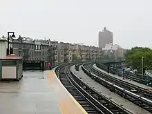
The Dyckman Street station has two side platforms and two tracks.[35] The station is built into the base of a steep hill known as Fort George. The southern end of the station lies at the northern portal of the Washington Heights Mine Tunnel, which takes the IRT Broadway–Seventh Avenue Line through the bedrock of Manhattan. Here, the line maintains a level grade through the tunnel.[3]:3 The portal of the tunnel is an arch made of rusticated granite blocks, atop which is a keystone and a concrete parapet. There is a rectangular pediment with the inscription "Fort George 1776-1906", flanked by scrolls, atop the center of the arch.[3]:6 North of the station, the terrain of Upper Manhattan drops abruptly and the line becomes elevated to Van Cortlandt Park–242nd Street.[35]
The platforms are offset slightly: the southbound platform extends further to the north than the northbound platform. A center express track, which is currently unused in revenue service, forms just north of this station and runs nonstop to just south of 242nd Street.[35] There used to be a spur track south of the station, but that was removed when the platforms were extended.
Station design
Both platforms have beige windscreens and red canopies with green frames at the center. The red metal roofs contain rafters and are supported by steel truss bars. Along the platform on either side of the canopy, there are waist-high cast-iron railings with lampposts. The southern end of the northbound platform is adjacent to a concrete retaining wall at the portal of the Washington Heights Mine Tunnel, which slopes down toward the north. There is a blue-and-green "DYCKMAN ST" mosaic on this retaining wall.[3]:5–6 The southern end of the southbound platform contains equipment rooms and is adjacent to Substation 17.[3]:6, 16
As with other original IRT elevated viaducts, the elevated structure north of Dyckman Street is carried on two column bents, one on each side of the road, at places where the tracks are no more than 29 feet (8.8 m) above the ground level. There is zigzag lateral bracing at intervals of every four panels.[3]:3–4[36]
Exit
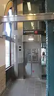
The station's only entrance is a station house slightly above ground level at the southern corner of Nagle Avenue, Dyckman Street, and Hillside Avenue.[37] Because of the street layout, the northern end of the station house resembles a wedge in plan. The station house is designed in the Beaux-Arts style with concrete facades that are designed to resemble ashlar.[3]:4 There is a ramp and stairs leading up from street level to the station house entrance, which consists of a pair of arches under the elevated viaduct.[3]:4[38] The northwestern corner of the station house contains a plinth, which supports the northern end of the southbound platform. The western facade of the station house, under the southbound platform, has seven arched windows facing Hillside Avenue.[3]:4
Inside the station house, the ceiling is supported by large metal I-beams and made of concrete. The eastern side of the ceiling is below the track bed and contains an arched ceiling, which is about 5 feet (1.5 m) lower than the rest of the ceiling. The north, west, and east walls contain a buff-brick wainscoting of Roman brick at the lowest part of the walls. The upper sections of these walls are clad with white glass tiles, topped by a green mosaic band about 12 inches (300 mm) wide.[3]:4–5 The southern wall contains a 1991 artwork called Flight by Wopo Holup. It features ceramic relief tiles depicting birds in flight.[3]:5[39] For the 2013 renovation, Holup commissioned an addition to her previous work, with a relief-tile depiction of the moon surrounded by a band of white mosaic tiles.[39][33]
The space is divided roughly in half by a turnstile bank, with an accompanying station agent's booth on the eastern wall. South of the turnstile bank, within fare control, one staircase from either side of the station house leads to each platform.[3]:4–5 An elevator also leads to the southbound platform. The elevator is of a "machine room-less" design and is the first of its type to be installed in the New York City Subway system.[29] The southern wall of the station house contains staff rooms.[3]:5, 16
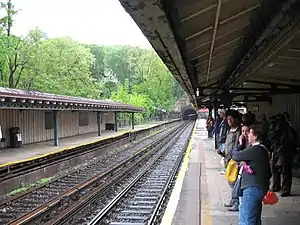 Platforms before renovation
_train_station_view.JPG.webp) Platforms during renovation
Platforms during renovation.JPG.webp) Platforms after renovation
Platforms after renovation
References
- "Station Developers' Information". Metropolitan Transportation Authority. Retrieved June 13, 2017.
- "Facts and Figures: Annual Subway Ridership 2014–2019". Metropolitan Transportation Authority. 2020. Retrieved May 26, 2020.
- "Dyckman Street Subway Station (IRT)" (PDF). National Register of Historic Places, National Park Service. September 17, 2004. Retrieved September 11, 2020.
- Walker, James Blaine (1918). Fifty Years of Rapid Transit — 1864 to 1917. New York, N.Y.: Law Printing. Retrieved November 6, 2016.
- "Interborough Rapid Transit System, Underground Interior" (PDF). New York City Landmarks Preservation Commission. October 23, 1979. Retrieved November 19, 2019.
- Report of the Board of Rapid Transit Railroad Commissioners for the City of New York For The Year Ending December 31, 1904 Accompanied By Reports of the Chief Engineer and of the Auditor. Board of Rapid Transit Railroad Commissioners. 1905. pp. 229–236.
- "Farthest North in Town by the Interborough". The New York Times. January 14, 1907. p. 18.
- District, New York (State) Public Service Commission First (January 1, 1913). Report of the Public Service Commission for the First District of the State of New York. J.B. Lyon Company.
- "Trains To Ship Canal: But They Whiz by Washington Heights Station" (PDF). The New York Times. March 13, 1906. Retrieved August 16, 2015.
- "Express to 221st Street: Will Run In the Subway To-day–New 181st Street Station Ready" (PDF). Retrieved September 1, 2016.
- "Our First Subway Completed At Last — Opening of the Van Cortlandt Extension Finishes System Begun in 1900 — The Job Cost $60,000,000 — A Twenty-Mile Ride from Brooklyn to 242d Street for a Nickel Is Possible Now". The New York Times. August 2, 1908. p. 10. Retrieved November 6, 2016.
- Brooklyn Daily Eagle Almanac. Brooklyn Daily Eagle. 1916. p. 119.
- "Open New Subway Lines to Traffic; Called a Triumph". The New York Times. August 2, 1918. p. 1. ISSN 0362-4331. Retrieved October 4, 2011.
- Hood, Clifton (1978). "The Impact of the IRT in New York City" (PDF). Historic American Engineering Record. pp. 146–207 (PDF pp. 147–208). Retrieved December 20, 2020.
 This article incorporates text from this source, which is in the public domain.
 - Report of the Public Service Commission for the First District of the State of New York For The Year Ending December 31, 1910. Public Service Commission. 1911.
- "Ten-car Trains in Subway to-day; New Service Begins on Lenox Av. Line and Will Be Extended to Broadway To-morrow". The New York Times. January 23, 1911. ISSN 0362-4331. Retrieved April 5, 2018.
- Report for the three and one-half years ending June 30, 1949. New York City Board of Transportation. 1949. hdl:2027/mdp.39015023094926.
- "More Long Platforms – Five Subway Stations on IRT to Accommodate 10-Car Trains" (PDF). The New York Times. July 10, 1948. p. 8. ISSN 0362-4331. Retrieved March 27, 2016.
- Brown, Nicole (May 17, 2019). "How did the MTA subway lines get their letter or number? NYCurious". amNewYork. Retrieved January 27, 2021.
- Friedlander, Alex; Lonto, Arthur; Raudenbush, Henry (April 1960). "A Summary of Services on the IRT Division, NYCTA" (PDF). New York Division Bulletin. Electric Railroaders' Association. 3 (1): 2.
- Brozan, Nadine (June 4, 1989). "'Skip-Stop' Subway Plan Annoys No. 1 Riders". The New York Times. ISSN 0362-4331. Retrieved June 15, 2016.
- Moore, Keith (June 10, 1988). "TA's skip-stop plan hit". New York Daily News. Retrieved November 8, 2018.
- "#1 Riders: Your Service is Changing". New York Daily News. August 20, 1989. Retrieved November 8, 2018.
- "Announcing 1 and 9 Skip-Stop Service on the Broadway-Seventh Avenue Line" (PDF). New York City Transit Authority. August 1989. Archived from the original (PDF) on June 26, 2020. Retrieved August 1, 2009.
- Lorch, Donatella (August 22, 1989). "New Service For Subways On West Side". The New York Times. ISSN 0362-4331. Retrieved June 15, 2016.
- Chan, Sewell (January 12, 2005). "MTA Proposes Dropping No. 9 Train". The New York Times. Retrieved April 18, 2010.
- Chan, Sewell (May 25, 2005). "On Its Last Wheels, No. 9 Line Is Vanishing on Signs". The New York Times. ISSN 0362-4331. Retrieved August 29, 2016.
- Zanoni, Carla (July 12, 2010). "$45 Million Dyckman Street Subway Stop Repair Won't Bring Disability Access". DNAinfo New York. Retrieved February 1, 2021.
- "Ceremony marks $31 million rehab of Dyckman Street 1 subway station". Metro US. February 6, 2014. Retrieved February 1, 2021.
- Rivoli, Dan (February 6, 2014). "Refurbished Dyckman St. station gets new elevator". amNewYork. Retrieved February 1, 2021.
- Donohue, Pete (July 22, 2011). "MTA agrees to make Dyckman St. subway station handicapped-accessible to settle lawsuit". New York Daily News. Retrieved February 1, 2021.
- Zanoni, Carla (July 21, 2011). "MTA Agrees to Add Elevator at Dyckman Street Subway Station Following Lawsuit". DNAinfo New York. Retrieved February 1, 2021.
- Dwyer, Jim (February 7, 2014). "A Moving Glass Box Conquers Uneven Terrain at a Subway Station". The New York Times. ISSN 0362-4331. Retrieved February 1, 2021.
- mtainfo (February 6, 2019). NYCT Public Event - Discussion About the Next Accessible Subway Stations - 02/06/2019 (video) – via YouTube.
- Dougherty, Peter (2006) [2002]. Tracks of the New York City Subway 2006 (3rd ed.). Dougherty. OCLC 49777633 – via Google Books.
- Transit Journal. 1904. p. 470. Retrieved April 16, 2020.
 This article incorporates text from this source, which is in the public domain.
 - "MTA Neighborhood Maps: Washington Heights" (PDF). Metropolitan Transportation Authority. 2015. Retrieved December 31, 2016.
- "mta.info - Accessibility". mta.info. Retrieved August 3, 2016.
- "Dyckman Street - Wopo Holup - Birds in Flight-Moon View, 2013". web.mta.info. Metropolitan Transportation Authority. Retrieved February 1, 2021.
External links
| Wikimedia Commons has media related to Dyckman Street (IRT Broadway – Seventh Avenue Line). |
- nycsubway.org – IRT West Side Line: Dyckman Street
- nycsubway.org – Flight Artwork by Wopo Holup (1991)
- Station Reporter – 1 Train
- The Subway Nut – Dyckman Street Pictures
- MTA's Arts For Transit – Dyckman Street (IRT Broadway–Seventh Avenue Line)
- Dyckman Street entrance from Google Maps Street View
- Platforms from Google Maps Street View
