Derinkuyu
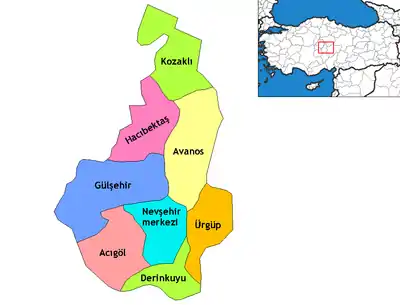
Derinkuyu ("deep well") (Cappadocian Greek: Μαλακοπή) is a town and district of Nevşehir Province in the Central Anatolia region of Turkey. According to 2010 census, population of the district is 22,114 of which 10,679 live in the town of Derinkuyu.[3][4] The district covers an area of 445 km2 (172 sq mi),[5] and the average elevation is 1,300 m (4,265 ft), with the highest point being Mt. Ertaş at 1,988 m (6,522 ft).
Derinkuyu | |
|---|---|
District | |
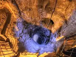
 Deep ventilation well in Derinkuyu Underground City | |
 Location of Derinkuyu within Turkey. | |
 Derinkuyu Location of Derinkuyu within Turkey. | |
| Coordinates: 38°22′N 34°44′E | |
| Country | |
| Region | Central Anatolia |
| Province | Nevşehir |
| Government | |
| • Governor | Murat Duru |
| • Mayor | Ahmet Balcı (MHP) |
| Area | |
| • District | 444.89 km2 (171.77 sq mi) |
| Elevation | 1,300 m (4,300 ft) |
| Population (2012)[2] | |
| • Urban | 10,804 |
| • District | 21,945 |
| • District density | 49/km2 (130/sq mi) |
| Time zone | UTC+2 (EET) |
| • Summer (DST) | UTC+3 (EEST) |
| Postal code | 50xxx |
| Area code(s) | 0384 |
| Licence plate | 50 |
| Climate | Csb |
| Website | www.derinkuyu.gov.tr |
Located in Cappadocia, Derinkuyu is notable for its large multi-level underground city (Derinkuyu Underground City), which is a major tourist attraction. The historical region of Cappadocia, where Derinkuyu is situated, contains several historical underground cities, carved out of a unique geological formation. They are not generally occupied. Over 200 underground cities at least two levels deep have been discovered in the area between Kayseri and Nevşehir, with around 40 of those having at least three levels. The troglodyte cities at Derinkuyu and Kaymaklı are two of the best examples of underground dwellings.
History
The oldest written source about underground structures is the writings of Xenophon. In his Anabasis he writes that the people living in Anatolia had excavated their houses underground, living well in accommodations large enough for the family, domestic animals, and supplies of stored food.[6] The first two floors of the Derinkuyu Underground City have been dated to this early period.
From Byzantine times (4th century CE) through 1923 Derinkuyu was known by its Cappadocian Greek inhabitants as Malakopea (Greek: Μαλακοπέα).[7] The underground city was greatly expanded in the middle Byzantine period to serve as a refuge from the raids of the Umayyad Arab and Abbasid armies, during the Arab–Byzantine wars (780-1180). The city contained food stores, kitchens, stalls, churches, wine and oil presses, ventilation shafts, wells, and a religious school. The Derinkuyu underground city has at least eight levels and depth of 85 m and could have sheltered thousands of people. The city continued to be used as protection from the Mongolian incursions of Timur in the 14th century.[8][9] After the region fell to the Ottomans the cities were used as refuges (Greek: καταφύγια). As late as the 20th century the town's inhabitants, called Cappadocian Greeks, were still using the underground chambers to escape periodic waves of Ottoman persecution.[10] (The Cambridge linguist Dawkins, who spent time in the towns from 1910-1911 while writing his book on Cappadocian Greek wrote, "their use as places of refuge in time of danger is indicated by their name καταφύγια, and when the news came of the recent massacres at Adana [in 1909], a great part of the population at Axo took refuge in these underground chambers, and for some nights did not venture to sleep above ground."[11]) When the Cappadocian Greeks were required to leave in 1923 in the Population exchange between Greece and Turkey the tunnels were finally abandoned.[12][13]
Images
 Staircase in the underground town of Derinkuyu, Cappadocia, Turkey
 Rolling stone door in the underground town of Derinkuyu, Cappadocia, Turkey
 Chamber in the underground town of Derinkuyu, Cappadocia, Turkey
See also
Notes
- "Area of regions (including lakes), km²". Regional Statistics Database. Turkish Statistical Institute. 2002. Retrieved 2013-03-05.
- "Population of province/district centers and towns/villages by districts - 2012". Address Based Population Registration System (ABPRS) Database. Turkish Statistical Institute. Retrieved 2013-02-27.
- Statistical Institute
- GeoHive. "Statistical information on Turkey's administrative units". Retrieved 2008-04-14.
- Statoids. "Statistical information on districts of Turkey". Retrieved 2008-04-14.
- Xen. An. 4.5.24-7.
- Peter Mackridge, "Some Pamphlets on Dead Greek Dialects': R.M. Dawkins and Modern Greek Dialectology", 1990. p. 205. "Anyone who attempts to find the Greek villages of Cappadocia today, either on the map or on the ground, is first faced by the problem that their names have been obliterated, a chauvinistic practice not only prevalent in modern Turkey, but practiced in Greece as well. Visitors to the so-called 'underground cities' at Kaymakli and Derinkuyu have difficulty in ascertaining that until 1923 they were called Anaku and Malakopi respectively (the latter being the Μαλακοπαία of Theophanes. Once located, however, these villages bear obvious traces of their Greek Christian past in the shape of sizable churches (some of which have been converted into mosques and are therefore well preserved, but with their frescoes covered with whitewash), and a number of rather elegant houses, whose Greekness is betrayed only by the initials and dates (usually about ten years before the 1923 exchange of populations."
- Kinross, Baron Patrick Balfour (1970). Within the Taurus: a journey in Asiatic Turkey. J. Murray. p. 168. ISBN 978-0-7195-2038-9.
Its inhabitants were Cappadocian Greeks, who may have found a refuge here, perhaps from Roman, from Iconoclast, or later from Turkish and Mongol threats. Urgup itself was the Byzantine Prokopion; the Emperor Nicephoros Phocas is said to have passed this way, after his Cilician campaign; and the neighborhood was populous enough to support, at different times, a number of bishoprics.
- Dawkins, R.M. (1916). Modern Greek in Asia Minor. A study of dialect of Silly, Cappadocia and Pharasa. Cambridge University Press. p. 17. Retrieved 25 October 2014.
these excavations are referred to as long ago as the campaigns of Timour Beg, one of whose captains was sent to hunt out the inhabitants of Kaisariyeh, who had taken refuge in their underground dwellings, and was killed by an arrow shot through the hole in one of the doors.
- Dawkins, R.M. (1916). Modern Greek in Asia Minor. A study of dialect of Silly, Cappadocia and Pharasa. Cambridge University Press. p. 16. Retrieved 25 October 2014.
their use as places of refuge in time of danger is indicated by their name καταφύγια, and when the news came of the recent massacres at Adana [in 1909], a great part of the population at Axo took refuge in these underground chambers, and for some nights did not venture to sleep above ground.
- Dawkins, R.M. (1916). Modern Greek in Asia Minor. A study of dialect of Silly, Cappadocia and Pharasa. Cambridge University Press. p. 16. Retrieved 25 October 2014.
- Darke, Diana (2011). Eastern Turkey. Bradt Travel Guides. pp. 139–140. ISBN 978-1-84162-339-9.
The area became an important frontier province during the 7th century when Arab raids on the Byzantine Empire began. By now the soft tufa had been tunneled and chambered to provide underground cities where a settled if cautious life could continue during difficult times. When the Byzantines re-established secure control between the 7th and 11th centuries, the troglodyte population surfaced, now carving their churches into rock faces and cliffs in the Goreme and Sogamli areas, giving Cappadocia its fame today. […] At any rate here they flourished, their churches remarkable for being cut into the rock, but interesting especially for their paintings, relatively well preserved, rich in coloring, and with an emotional intensity lacking in the formalism of Constantinople; this is one of the few places where paintings from the pre-iconoclastic period have survived. Icons continued to be painted after the Seljuk conquest of the area in the 11th century, and the Ottoman conquest did not interfere with the Christian practices in Cappadocia, where the countryside remained largely Greek, with some Armenians. But decline set in and Goreme, Ihlara and Soganli lost their early importance. The Greeks finally ending their long history here with the mass exchange of populations between Turkey and Greece in 1923.
- Rodley, Lyn (2010). Cave Monasteries of Byzantine Cappadocia. Cambridge University Press. p. 1. ISBN 978-0-521-15477-2.
The tenth-century historian Leo the Deacon records a journey to Cappadocia made by Nikephoros Phokas shortly before he became emperor. Perhaps to recapture the attention of readers beginning to tire of troop movements he also offers a scrap of information about a curiosity of the region to which the emperor was heading: its inhabitants were once called troglodytes, because ‘they went underground in holes, clefts and labyrinths, as it were in dens and burrows’. This brief note was probably not based on first-hand knowledge but it might have been prompted by an awareness of the vast number of rock-cut cavities in an area to the west and southwest of Kaisareia (Kayseri of modern Turkey). Had Leo been more inclined to garrulous digression (or perhaps just better informed), he might have supplied more details of the troglodyte region and the task of bringing scholarly order to the hundreds of rock-cut monuments and other cavities in the area might have been much similar. … At this time the region was still inhabited by a mixed population of Turkish-speaking Moslems and Greek-speaking Christians. The latter group left for Greece in the early 1920s, during an exchange of population of minorities that was part of the radical social re-ordering initiated by Kemal Atatürk; they were replaced by Turks from Greece, mostly from Thrace. In the two decades before this upheaval, however, members of the local Greek population acted as guides to Guillaume de Jerphanion, who made several visits to the volcanic valleys and wrote his meticulous descriptions of many painted Byzantine rock-cut churches.
References
- Falling Rain Genomics, Inc. "Geographical information on Derinkuyu, Turkey". Retrieved 2008-04-14.
- Governorship of Derinkuyu, Turkey. "General information on Derinkuyu, Nevşehir" (in Turkish). Archived from the original on 2008-06-30. Retrieved 2008-04-14.
External links
| Wikimedia Commons has media related to Derinkuyu. |
- District governor's official website (in Turkish)
- District municipality's official website (in Turkish)