Clark Township, Pope County, Arkansas
Clark Township is one of nineteen current townships in Pope County, Arkansas, USA.[2] As of the 2010 census, its unincorporated population was 3,386. The Arkansas Nuclear One power plant is located here near the city of London, just outside Russellville.
Clark Township | |
|---|---|
 Clark Township Location in Arkansas | |
| Coordinates: 35°19′45″N 93°14′46″W | |
| Country | |
| State | |
| County | Pope |
| Established | prior to 1836[1] |
| Area | |
| • Total | 31.79 sq mi (82.3 km2) |
| • Land | 25.55 sq mi (66.2 km2) |
| • Water | 6.24 sq mi (16.2 km2) |
| Elevation | 361 ft (110 m) |
| Population (2010) | |
| • Total | 3,386 |
| • Density | 132.5/sq mi (51.2/km2) |
| Time zone | UTC-6 (CST) |
| • Summer (DST) | UTC-5 (CDT) |
| Zip Code | 72847 (London) |
| Area code(s) | 479 |
| GNIS feature ID | 69700 |
Geography
According to the United States Census Bureau, Clark Township covers an area of 31.79 square miles (82.3 km2); 25.55 square miles (66.2 km2) of land and 6.24 square miles (16.2 km2) of water. Clark Township gave part of its area to Bayliss Township in 1876.[1]
Cities, towns, and villages
References
- United States Census Bureau 2008 TIGER/Line Shapefiles
- United States Board on Geographic Names (GNIS)
- United States National Atlas
- Baker, Russell (2003). Arkansas Township Atlas 1819-1930. Little Rock, AR: Arkansas Genealogical Society. p. 148. ISBN 0-9723085-6-3.
- "Clark Township, Pope County, Arkansas." U.S. Census Bureau. Breakdown. Retrieved June 20, 2010.
External links
Municipalities and communities of Pope County, Arkansas, United States | ||
|---|---|---|
| Cities | 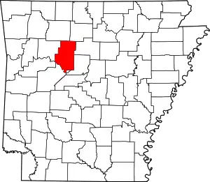 Map of Arkansas highlighting Pope County | |
| Town | ||
| Unincorporated communities |
| |
| Townships | ||
| ||
This article is issued from Wikipedia. The text is licensed under Creative Commons - Attribution - Sharealike. Additional terms may apply for the media files.