Chinatown station (MBTA)
Chinatown is a rapid transit station on the Massachusetts Bay Transportation Authority (MBTA) Orange Line, located at the edge of the Chinatown neighborhood in downtown Boston. The station has two offset side platforms, which run under Washington Street from Hayward Place to Lagrange Street. The three entrances are located at the intersection of Washington Street with Essex and Boylston streets. Like all Orange Line stations, both the subway platforms and all bus connections are fully accessible.
Chinatown | ||||||||||||||||||||
|---|---|---|---|---|---|---|---|---|---|---|---|---|---|---|---|---|---|---|---|---|
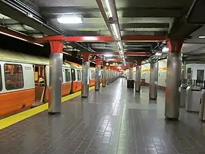
 A train at the inbound (northbound) platform in 2011 | ||||||||||||||||||||
| Location | 640 Washington Street and 1 Boylston Street Boston, Massachusetts | |||||||||||||||||||
| Coordinates | 42.3522°N 71.0627°W | |||||||||||||||||||
| Line(s) | Washington Street Tunnel | |||||||||||||||||||
| Platforms | 2 side platforms | |||||||||||||||||||
| Tracks | 2 | |||||||||||||||||||
| Connections | ||||||||||||||||||||
| Construction | ||||||||||||||||||||
| Disabled access | Yes | |||||||||||||||||||
| History | ||||||||||||||||||||
| Opened | November 30, 1908 (Orange Line) July 20, 2002 (Silver Line) | |||||||||||||||||||
| Previous names | Boylston Street / Essex (1908–1967) Essex (1967–1987)[1] | |||||||||||||||||||
| Passengers | ||||||||||||||||||||
| FY2019 | 5,747 boardings (weekday average)[2] | |||||||||||||||||||
| Services | ||||||||||||||||||||
| ||||||||||||||||||||
Boylston (southbound) and Essex (northbound) stations opened as part of the Washington Street Tunnel in 1908. The whole station was renamed Essex in 1967, then Chinatown in 1987. The southbound side was modernized in the 1970s, followed by the northbound side a decade later. The latter renovation added an elevator to the northbound side, with a southbound elevator added in 2002. Silver Line service began in 2002. The MBTA plans to reopen two 1970s-closed entrances at Hayward Place and Lagrange Street.
Station layout

Chinatown station has two side platforms serving the two tracks of the Washington Street Tunnel. As with Downtown Crossing and State, the platforms are offset; the northbound platform runs north from Essex Street to Hayward Place, while the southbound platform runs south from Boylston Street (opposite Essex) to Lagrange Street. The platforms are also somewhat vertically offset, with the northbound platform at a higher elevation than the southbound. The two halves of the station are separate, with no passage between them.
The northbound platform has entrances integrated into commercial buildings on Washington Street north and south of Essex Street (the latter entrance is in the Liberty Tree Building), leading to a fare lobby under Essex Street. An elevator is located in the northern entrance. The southbound platform has a single entrance and elevator on Boylston Street west of Washington Street, leading to a fare lobby under a triangular plaza. SL5 buses stop adjacent to the northern northbound entrance; SL4 and route 11 buses stop adjacent to the south entrance.[3]
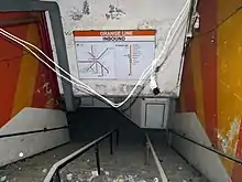
The northbound platform formerly had an additional entrance at Hayward Place, with separate entrance and exit headhouses on the north side of Hayward Place; the concourse and headhouses are extant (and used as emergency exits) but are embedded into a newer building. A disused northbound entrance is located on the south side of Essex Street east of Washington Street. A disused entrance to the southbound platform was located at Lagrange Street; it also serves as an emergency exit. A disused sub-passage connects the inbound and outbound platforms.[4]
History


The station originally opened on November 30, 1908 along with the rest of the Washington Street Tunnel. At this time, the Boston Elevated Railway's Main Line (which later became the Orange Line) was moved from the Tremont Street Subway into this new subway tunnel. As with the other stations of the Washington Street Tunnel, the platforms were largely separated and given different names - Boylston for the southbound platform, and Essex for the northbound side.[5] On February 11, 1967, as part of a larger renaming of Orange Line stations, the entire station became Essex.[1]
In May 1972, the MBTA opened a new southbound headhouse to accommodate a realignment of Boylston Street.[6][7] That month, the agency received a federal grant that funded two-thirds of a $14.3 million modernization program.[6][8] As part of that project, the MBTA investigated the feasibility of connecting Essex, Park Street, Washington, and State with pedestrian tunnels.[9] (The Winter Street Concourse was opened to passengers in 1979, connecting Park Street and Washington, but Essex and State were never connected with the others.[10]) A $378,323 contract for modernization work on the southbound side, including a platform extension, was awarded in 1975; the Lagrange Street and Hayward Place entrances were likely closed during the work.[1][11]
As part of the renovation, George Greenamyer constructed an 18-by-9-foot (5.5 m × 2.7 m), 20,000-pound (9,100 kg) artwork on the southbound platform in 1976.[12][13] The first sculpture in the MBTA's arts program, it was styled after an old steam locomotive, and incorporated scrapped locomotive and truck parts.[13][14] The three locomotive driving wheels were recast from original wood molds owned by the Edaville Railroad.[13] The sculpture, Farewell to Steam, was later relocated to the commuter rail level at Back Bay station.[15]
A $3.3 million modernization of the northbound side was approved on April 2, 1986, with a groundbreaking held on May 30.[16] The project added an elevator to the northbound platform and a new entrance north of Essex Street; the Essex Street headhouse was closed.[17] An extension of the northbound platform was completed shortly before six-car train service began on August 18, 1987.[1] The renovation added a new artwork to the station: Colors on the Line, by Toshihiro Katayama, consists of 44 colorful enameled steel panels along the wall of the northbound track.[18][19] Katayama wrote that ""I instantly heard the voice of this station telling me...to relieve the darkness with a range of bright colors."[20] On May 4, 1987, the station was renamed Chinatown concurrent with the opening of the Southwest Corridor; the change (likely an effort to rebrand the declining Combat Zone) had been approved in 1985 as part of a series of station name changes.[21][1]
The Millennium Place development, completed in 2001, was constructed on a long-vacant lot surrounding the southbound headhouse.[22] A simultaneous station renovation included a rebuilt headhouse and a new elevator built into the new development. The $5 million project, completed in 2002, made the station fully accessible.[23][24][25] Silver Line service on Washington Street between Dudley and Downtown Crossing (now route SL5) started on July 20, 2002. Additional service to South Station (route SL4) began on October 15, 2009. Both routes operate on one-way loops in downtown Boston, serving Chinatown station only in the northbound direction.[1]
Improvements to wayfinding signage began in mid-2019 and are expected to be complete by the end of 2020.[26] In May 2020, the MBTA awarded a design contract for accessibility renovations at both Chinatown and State stations. The work at Chinatown includes reopening the Hayward Place and Lagrange Street entrances with added elevators, replacement of the existing elevators, and lobby renovations.[27]
References
- Belcher, Jonathan. "Changes to Transit Service in the MBTA district" (PDF). NETransit.
- "A Guide to Ridership Data". MassDOT/MBTA Office of Performance Management and Innovation. June 22, 2020. p. 9.
- "Chinatown Station Neighborhood Map" (PDF). Massachusetts Bay Transportation Authority. July 2012. Archived from the original (PDF) on July 17, 2014.
- "Plates 8 and 9". Annual report of the Boston Transit Commission, Volume 11. Boston Transit Commission. 1905. pp. 50–53.
- Elder, Andrew; Fox, Jeremy C. (2013). Boston's Orange Line. Arcadia Publishing. p. 69. ISBN 9781467120470.
- Eight Annual Report. Massachusetts Bay Transportation Authority. 1972. pp. 14–15 – via Internet Archive.
- Carr, Rpbert B. (May 24, 1974). "3 ultra-modern subway kiosks planned by MBTA at Park St". Boston Globe. p. 6 – via Newspapers.com.

- Carr, Robert B. (July 26, 1972). "Park St. station facelift due". Boston Globe. p. 3 – via Newspapers.com.

- Plotkin, A.S. (March 1, 1974). "4 downtown MBTA stops may be linked". Boston Globe. p. 5 – via Newspapers.com.

- Clarke, Bradley H.; Cummings, O.R. (1997). Tremont Street Subway: A Century of Public Service. Boston Street Railway Association. p. 49. ISBN 0938315048.
- Eleventh Annual Report. Massachusetts Bay Transportation Authority. 1975. p. 13 – via Internet Archive.
- Robb, Christina (November 11, 1976). "Calendar Choice: interior artscapes". Boston Globe. p. 66 – via Newspapers.com.

- "Yesterday's junk-- Today's work of art". The Comment. Vol. 50 no. 8. Bridgewater State College. April 6, 1977. p. 4.
- "[Untitled photo]". Boston Globe. July 10, 1976. p. 11 – via Newspapers.com.

- "On the Commuter Line" (PDF). Massachusetts Bay Transportation Authority.
- Sanborn, George M. (1992). A Chronicle of the Boston Transit System. Massachusetts Bay Transportation Authority – via Massachusetts Institute of Technology.
- MBTA : ACCESS; The Guide to Accessible Services and Facilities. Massachusetts Bay Transportation Authority. June 1992. p. 12 – via Internet Archive.
- "MBTA hopes riders will be transported by art". Boston Globe. April 27, 1988. pp. 21, 35 – via Newspapers.com. (second page)

- "On the Orange Line" (PDF). Massachusetts Bay Transportation Authority. p. 4.
- Durso, Holly Bellocchio (June 2011). Subway Spaces as Public Places: Politics and Perceptions of Boston's T (MCP). Massachusetts Institute of Technology. p. 58.
- Crocket, Douglas S. (July 27, 1985). "T board votes to change the names of some stations". Boston Globe. p. 26 – via Newspapers.com.

- Allis, Sam (March 11, 2001). "Sizing up the Ritz". Boston Globe. p. 2 – via Newspapers.com.

- Tran Systems and Planners Collaborative (August 24, 2007). "Evaluation of MBTA Paratransit and Accessible Fixed Route Transit Services: Final Report" (PDF). Massachusetts Bay Transportation Authority.
- "Executive Summary" (PDF). Program of Mass Transportation. Boston Regional Metropolitan Planning Organization. January 2004. p. ES-8. Archived from the original (PDF) on February 20, 2012.
- "Accessibility Projects at the MBTA" (PDF). Massachusetts Bay Transportation Authority. March 2005.
- Brelsford, Laura (May 26, 2020). "SWA Initiatives—May 2020" (PDF). p. 5.
- "Architectural and Engineering Services for Station and Accessibility Improvements" (PDF). Massachusetts Bay Transportation Authority. May 21, 2020.
External links
| Wikimedia Commons has media related to Chinatown station (MBTA). |
- MBTA - Chinatown
- Entrances on Google Maps Street View: northbound (north), northbound (south), southbound
- Former entrances: Hayward Place, Essex Street, Lagrange Street