Capen Street station
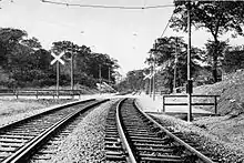
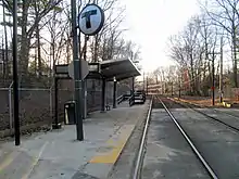
Capen Street is a light rail station in Milton, Massachusetts. It serves the MBTA Ashmont–Mattapan High Speed Line. It is located on Capen Street off Eliot Street; the westernmost of the four MBTA stations in Milton, it consists of two side platforms flanking the eponymous street's grade crossing. The platforms are staggered to allow trains to make the stop at Capen Street before crossing the street itself, as there is no signal at the grade crossing.[4] Capen Street is accessible via wooden ramps on both platforms. Capen Street opened in September 1930 as an infill station on the line.[1]
Capen Street | |||||||||||
|---|---|---|---|---|---|---|---|---|---|---|---|
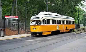
 Trolley at the outbound platform at Capen Street | |||||||||||
| Location | Capen Street off Eliot Street Milton, Massachusetts | ||||||||||
| Coordinates | 42°16′03″N 71°05′15″W | ||||||||||
| Line(s) | Milton Branch | ||||||||||
| Platforms | 2 side platforms | ||||||||||
| Tracks | 2 | ||||||||||
| Construction | |||||||||||
| Disabled access | Yes | ||||||||||
| History | |||||||||||
| Opened | c. September 1930[1] | ||||||||||
| Rebuilt | June 24, 2006 – December 22, 2007[2] | ||||||||||
| Passengers | |||||||||||
| 2010 | 58 (weekday average boardings)[3] | ||||||||||
| Services | |||||||||||
| |||||||||||
History


The Dorchester and Milton Branch Railroad opened from Neponset to Mattapan in December 1847.[5] Service was discontinued on August 26, 1929, as the new high-speed trolley line was completed from Ashmont to Milton by the Boston Elevated Railway (BERy).[6][2] The trolley line was extended from Milton to Mattapan on December 21, 1929, with new intermediate stops at Central Avenue and Valley Road.[7][2]
Residents on Capen Street, having to use the Valley Road stop despite the line crossing Capen Street, requested a station of their own; it was considered a likely possibility at the time of the line's opening.[8] After considering the walking distance from Capen Street to Valley Road and Mattapan, the BERy granted the request. The Boston Transit Department constructed 12-foot (3.7 m) by 100-foot (30 m) gravel platforms with overhead lighting. The completed station opened as a flag stop in September 1930.[1] A second infill stop at Butler Street opened the next year.[2]
On October 8, 1982, a shotgun-wielding man attempted to rob the six passengers aboard an inbound trolley at Capen Street. One of the passengers foiled the attempt by grabbing the unloaded gun from the robber.[9]
The MBTA closed the line on June 24, 2006 to allow a new viaduct to be constructed at Ashmont station. During the closure, all stations on the line were modernized and (except for Valley Road) made accessible. The old shelter and platforms were replaced by modern platforms with canopies, with a wooden ramp on each platform for accessibility. Trolley service resumed on December 22, 2007.[2]
References
- Boston Transit Department (1931). Report of the Transit Department for the Year Ending December 31, 1930. City of Boston Printing Department. p. 46 – via Internet Archive.
- Belcher, Jonathan. "Changes to Transit Service in the MBTA district" (PDF). NETransit.
- "Ridership and Service Statistics" (PDF) (14th ed.). Massachusetts Bay Transportation Authority. 2014.
- O'Regan, Gerry; Pickering, Bob (2012). "MBTA Mattapan–Ashmont Line". NYCsubway.org. Retrieved 16 December 2012.
- Karr, Ronald Dale (1995). The Rail Lines of Southern New England. Branch Line Press. p. 315. ISBN 0942147022.
- "ALLOWS NEW HAVEN TO STOP SERVICE: Ruling as to Branch From Neponset and Mattapan Public Utilities Order Effective With Rapid Transit to Milton". Boston Daily Globe. August 1, 1928. p. 8. ProQuest 757576898.
- "ASHMONT-MATTAPAN HIGH SPEED TROLLEY LINE TO OPEN SATURDAY". Boston Daily Globe. December 15, 1929. p. A11. ProQuest 758187960.
- "MAYOR PILOTS PARTY OVER MATTAPAN LINE: Chairman Johnson of Milton Also Operates Car--Transit Extension To Carry Public Tomorrow". Boston Daily Globe. December 20, 1929. p. 1. ProQuest 758199898.
- "MAN FOILS SHOTGUN HOLDUP ON MILTON T LINE". Boston Globe. October 10, 1982. ProQuest 294088997.
External links
| Wikimedia Commons has media related to Capen Street station. |