Careys Peak
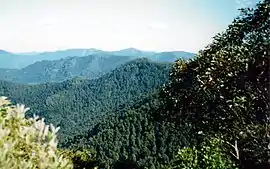
Careys Peak is a peak in the Williams Range, part of the Mount Royal Range, located in the Upper Hunter region of New South Wales, Australia. At 1,544 metres (5,066 ft) above sea level, it is one of the higher points in Barrington Tops National Park,[1] some 200 kilometres (120 mi) north of Sydney. The peak is at the edge of the Barrington Tops plateau, within the declared wilderness of the World Heritage Gondwana Rainforests of Australia.
| Careys Peak | |
|---|---|
 View from Careys Peak | |
| Highest point | |
| Elevation | 1,544 m (5,066 ft) |
| Coordinates | 32°03.041′S 151°27.558′E |
| Geography | |
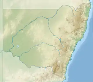
 Careys Peak Location in New South Wales | |
| Location | Barrington Tops National Park, New South Wales, Australia |
| Parent range | Williams Range, Mount Royal Range |
| Geology | |
| Age of rock | Eocene |
| Mountain type | Alkali Gabbro |
Wilderness streams, such as the Allyn River and Williams River rise nearby. On a clear day, the higher peaks of the Blue Mountains may be seen. And looking south east, the sands of Stockton Beach on the coast may be viewed. The scenic appeal of the area is well regarded. Particularly the large dark stands of rainforest and snow gum wilderness.[2] Careys Peak is a popular camping and bushwalking destination.[3] Many years ago, a skiing slope was cleared behind Careys Peak. It has since disappeared in natural bush re-growth.[4][5]
Name
Carey’s Peak is named after a local drover.[6] In 1839, 500 cattle were herded to Barrington Tops during a drought, but it snowed for 21 days that winter. All of the cattle died and the drover’s tents were blown away, so Carey suggested using the cattle hides to build a shelter.[7]
Geology
The geology of the area includes Alkali Gabbro, a type of igneous rock. Careys Peak was a vent of the Barrington Volcano. During the Eocene Period, a large basalt flow covered most of the nearby plateau. Below are older Permian Granodiorites and Devonian-Carboniferous sedimentary rocks, such as mudstones, siltstones, minor conglomerates and limestones.[2][8]
Flora

The surrounding area is heavily forested. Sub alpine woodland grows on the plateau. On the escarpment, Cool temperate rainforest is dominated by the Antarctic beech. Other interesting plants nearby include the snow gum, southern sassafras and broad-leaved pepperbush.[2][9] A two pronged landslip occurred in the rainforest at Careys Peak in 1978. This area is now slowly being naturally re-vegetated, initially by non-rainforest species. It is expected to return to the original Antarctic beech rainforest.[10]
Fauna
Animals in the area include wombats, eastern quoll, pademelons, eastern grey kangaroos and swamp wallabies. Lyrebirds may be seen in the undergrowth, and yellow-tailed black cockatoos are common overhead.[11]
References
- Barrington Tops State Forests - map published by the Forestry Commission of New South Wales, 1980s
- Adam, Paul (1987). New South Wales Rainforests - The Nomination for the World Heritage List. National Parks & Wildlife Service of NSW. pp. 78, 122. ISBN 0-7305-2075-7.
- "Barrington Tops National Park - lookouts & scenery". Office of Environment & Heritage. NSW Government. Archived from the original on 18 April 2012. Retrieved 29 May 2012.
- Caroyln, Swanson. "A walk on the wild side". Financial Review. Newcastle Herald. Retrieved 30 May 2012.
- "Forums - Snow Talk". Ski.com.au. Archived from the original on 12 November 2012. Retrieved 30 May 2012.
- SCANLON, MIKE (10 June 2016). "A loved place to stay". Newcastle Herald. Retrieved 4 October 2020.
- SCANLON, MIKE (10 June 2016). "A loved place to stay". Newcastle Herald. Retrieved 4 October 2020.
- Robert Wallace Johnson; Jan Knutson; Stuart Ross Taylor (1989). Intraplate Volcanism: In Eastern Australia and New Zealand. Cambridge University Press. p. 123. ISBN 978-0-521-38083-6.
- Royal Botanic Gardens Melbourne - Careys Peak Atherosperma in their collection
- Floyd, Alexander G. (1990). Australian Rainforests in New South Wales. 2. Chipping Norton, Australia: Surrey Beatty & Sons. p. 83. ISBN 0-949324-32-9. (other publication details, included in citation)
- "Barrington Tops". Top Spots. Retrieved 30 May 2012.