Céré-la-Ronde
Céré-la-Ronde is a commune in the Indre-et-Loire department in central France.
Céré-la-Ronde | |
|---|---|
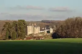 Chateau of Monpoupon | |
.svg.png.webp) Coat of arms | |
Location of Céré-la-Ronde 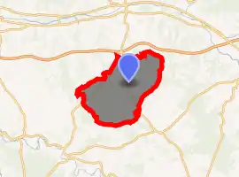
| |
 Céré-la-Ronde  Céré-la-Ronde | |
| Coordinates: 47°15′41″N 1°11′27″E | |
| Country | France |
| Region | Centre-Val de Loire |
| Department | Indre-et-Loire |
| Arrondissement | Loches |
| Canton | Bléré |
| Government | |
| • Mayor (2008–2014) | Patrice Lécureuil |
| Area 1 | 49.2 km2 (19.0 sq mi) |
| Population (2017-01-01)[1] | 459 |
| • Density | 9.3/km2 (24/sq mi) |
| Time zone | UTC+01:00 (CET) |
| • Summer (DST) | UTC+02:00 (CEST) |
| INSEE/Postal code | 37046 /37460 |
| Elevation | 84–186 m (276–610 ft) |
| 1 French Land Register data, which excludes lakes, ponds, glaciers > 1 km2 (0.386 sq mi or 247 acres) and river estuaries. | |
Population
| Year | Pop. | ±% |
|---|---|---|
| 1793 | 824 | — |
| 1800 | 854 | +3.6% |
| 1806 | 845 | −1.1% |
| 1821 | 895 | +5.9% |
| 1831 | 926 | +3.5% |
| 1836 | 917 | −1.0% |
| 1841 | 940 | +2.5% |
| 1846 | 964 | +2.6% |
| 1851 | 990 | +2.7% |
| 1856 | 995 | +0.5% |
| 1861 | 994 | −0.1% |
| 1866 | 975 | −1.9% |
| 1872 | 1,021 | +4.7% |
| 1876 | 1,052 | +3.0% |
| 1881 | 1,085 | +3.1% |
| 1886 | 1,127 | +3.9% |
| 1891 | 1,148 | +1.9% |
| 1896 | 1,134 | −1.2% |
| 1901 | 1,135 | +0.1% |
| 1906 | 1,106 | −2.6% |
| 1911 | 1,082 | −2.2% |
| 1921 | 975 | −9.9% |
| 1926 | 977 | +0.2% |
| 1931 | 889 | −9.0% |
| 1936 | 804 | −9.6% |
| 1946 | 734 | −8.7% |
| 1954 | 746 | +1.6% |
| 1962 | 662 | −11.3% |
| 1968 | 640 | −3.3% |
| 1975 | 571 | −10.8% |
| 1982 | 481 | −15.8% |
| 1990 | 435 | −9.6% |
| 1999 | 437 | +0.5% |
| 2006 | 414 | −5.3% |
| 2009 | 437 | +5.6% |
References
- "Populations légales 2017". INSEE. Retrieved 6 January 2020.
| Wikimedia Commons has media related to Céré-la-Ronde. |
| Authority control |
|---|
This article is issued from Wikipedia. The text is licensed under Creative Commons - Attribution - Sharealike. Additional terms may apply for the media files.