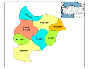
Bilecik
Bilecik is the provincial capital of Turkey's Bilecik Province. The population of the town is 221,693 (as of 2018). The mayor is Semih Şahin (CHP).
Bilecik | |
|---|---|
 Bilecik  Bilecik  Bilecik .svg.png.webp) Bilecik | |
| Coordinates: 40°08′35″N 29°58′45″E | |
| Country | Turkey |
| Province | Bilecik |
| Government | |
| • Mayor | Semih Şahin (CHP) |
| Area | |
| • District | 840.47 km2 (324.51 sq mi) |
| Population (2012)[2] | |
| • Urban | 51,260 |
| • District | 66,887 |
| • District density | 80/km2 (210/sq mi) |
| Website | www.bilecik.bel.tr |
The town is famous for its numerous restored Turkish houses. It is increasingly becoming more attractive to tourists. With its rich architectural heritage, Bilecik is a member of the European Association of Historic Towns and Regions.[3]
30 kilometres (19 miles) southeast from Bilecik is Söğüt, a small town, where the Ottoman Empire was founded in 1299.
Climate
Bilecik has a hot summer mediterranean climate (Köppen climate classification: Csa), with cool, wet and often snowy winters, and hot and dry summers. Summers are hot and dry with temperatures usually exceeding 30 °C (86 °F) during the peaks of summer which are the driest months. Winters are cold and it frequently snows between the months of December and March.
| Climate data for Bilecik | |||||||||||||
|---|---|---|---|---|---|---|---|---|---|---|---|---|---|
| Month | Jan | Feb | Mar | Apr | May | Jun | Jul | Aug | Sep | Oct | Nov | Dec | Year |
| Average high °C (°F) | 6.0 (42.8) |
7.7 (45.9) |
11.7 (53.1) |
16.9 (62.4) |
21.9 (71.4) |
25.9 (78.6) |
28.5 (83.3) |
28.5 (83.3) |
24.8 (76.6) |
19.3 (66.7) |
13.0 (55.4) |
7.7 (45.9) |
17.7 (63.8) |
| Daily mean °C (°F) | 2.5 (36.5) |
3.6 (38.5) |
6.8 (44.2) |
11.6 (52.9) |
16.1 (61.0) |
20.0 (68.0) |
22.3 (72.1) |
22.0 (71.6) |
18.4 (65.1) |
13.8 (56.8) |
8.5 (47.3) |
4.4 (39.9) |
12.5 (54.5) |
| Average low °C (°F) | −0.3 (31.5) |
0.3 (32.5) |
2.6 (36.7) |
6.8 (44.2) |
10.7 (51.3) |
14.2 (57.6) |
16.3 (61.3) |
16.4 (61.5) |
13.1 (55.6) |
9.5 (49.1) |
5.1 (41.2) |
1.6 (34.9) |
8.0 (46.4) |
| Average precipitation mm (inches) | 50.5 (1.99) |
39.5 (1.56) |
43.3 (1.70) |
42.3 (1.67) |
42.9 (1.69) |
35.3 (1.39) |
19.3 (0.76) |
10.6 (0.42) |
22.0 (0.87) |
47.5 (1.87) |
43.0 (1.69) |
55.4 (2.18) |
451.6 (17.79) |
| Average rainy days | 13.8 | 13.1 | 12.5 | 11.3 | 10.1 | 7.6 | 4.6 | 3.7 | 5.3 | 8.8 | 10.6 | 13.5 | 114.9 |
| Mean monthly sunshine hours | 102.3 | 106.4 | 151.9 | 183 | 254.2 | 294 | 322.4 | 310 | 249 | 179.8 | 126 | 93 | 2,372 |
| Source: Devlet Meteoroloji İşleri Genel Müdürlüğü [4] | |||||||||||||
References
- "Area of regions (including lakes), km²". Regional Statistics Database. Turkish Statistical Institute. 2002. Retrieved 2013-03-05.
- "Population of province/district centers and towns/villages by districts - 2012". Address Based Population Registration System (ABPRS) Database. Turkish Statistical Institute. Retrieved 2013-02-27.
- "HistoricTowns.org - Turkey". Archived from the original on 2008-09-10. Retrieved 2006-05-13.
- "İl ve İlçelerimize Ait İstatistiki Veriler- Meteoroloji Genel Müdürlüğü". Dmi.gov.tr. Archived from the original on 2013-01-17. Retrieved 2013-03-26.
External links
| Wikimedia Commons has media related to Bilecik. |
