Anguilcourt-le-Sart
Anguilcourt-le-Sart is a commune in the department of Aisne in the Hauts-de-France region of northern France.
Anguilcourt-le-Sart | |
|---|---|
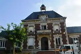
 Anguilcourt-le-Sart Town Hall | |
Location of Anguilcourt-le-Sart 
| |
 Anguilcourt-le-Sart  Anguilcourt-le-Sart | |
| Coordinates: 49°41′23″N 3°26′39″E | |
| Country | France |
| Region | Hauts-de-France |
| Department | Aisne |
| Arrondissement | Laon |
| Canton | Tergnier |
| Intercommunality | Chauny-Tergnier-La Fère |
| Government | |
| • Mayor (2014-2020) | Bernard Lemire |
| Area 1 | 9.14 km2 (3.53 sq mi) |
| Population (2017-01-01)[1] | 315 |
| • Density | 34/km2 (89/sq mi) |
| Time zone | UTC+01:00 (CET) |
| • Summer (DST) | UTC+02:00 (CEST) |
| INSEE/Postal code | 02017 /02800 |
| Elevation | 50–111 m (164–364 ft) (avg. 56 m or 184 ft) |
| 1 French Land Register data, which excludes lakes, ponds, glaciers > 1 km2 (0.386 sq mi or 247 acres) and river estuaries. | |
The inhabitants of the commune are known as Anguilcourtois or Anguilcourtoises[2]
Notable incidents
On 19 May 1983, 41 barrels of highly toxic chemical waste (dioxin-based), originating from the Seveso disaster, were found in an unused abattoir in Anguilcourt-le-Sart. The barrels, which had been illegally abandoned here by a transport contractor, were transferred the same evening to a military base near Sissonne. They were later destroyed in a high-temperature incinerator in Switzerald.[3]
Geography
Anguilcourt-le-Sart is located some 30 km south-east of Saint-Quentin and 25 km north-west of Laon. The A26 autoroute (Autoroute des Anglais, E17) from Saint-Quentin to Rheims passes through the north-eastern part of the commune but has no exit in the commune. Access to the commune is by the D69 road from Renansart in the north-east passing through the heart of the commune and village and continuing south to Les Larris. The D643 road also enters the commune from Achery in the west through the village and continuing east to Nouvion-le-Comte. the commune is almost entirely farmland except for some forest in the south-west.[4]
The Serre river flows through the commune from east to west just south of the village forming a part of the western boundary of the commune before joining the Oise at Le Travers.[4]
Administration
List of Successive Mayors of Anguilcourt-le-Sart[5]
| From | To | Name | Party | Position |
|---|---|---|---|---|
| 1995 | 2008 | Hubert Duez | DVD | |
| 2008 | Present | Bernard Lemire |
(Not all data is known)
Population
| Year | Pop. | ±% |
|---|---|---|
| 2006 | 279 | — |
| 2007 | 280 | +0.4% |
| 2008 | 279 | −0.4% |
| 2009 | 286 | +2.5% |
| 2010 | 292 | +2.1% |
| 2011 | 298 | +2.1% |
| 2012 | 303 | +1.7% |
| 2013 | 304 | +0.3% |
| 2014 | 308 | +1.3% |
| 2015 | 310 | +0.6% |
| 2016 | 313 | +1.0% |

Sites and Monuments

The Garden at Fort Mayot![]() is registered as an historical monument.[6]
is registered as an historical monument.[6]
Notes
References
- "Populations légales 2017". INSEE. Retrieved 6 January 2020.
- Inhabitants of Aisne (in French)
- Sevesto disaster chronology, Société des Infirmier(e)s de Soins Intensifs, pp. 11-12, Accessed 1 June 18 at https://www.siznursing.be/index.php?preaction=joint&id_joint=71790
- Google Maps
- List of Mayors of France (in French)
- Ministry of Culture, Mérimée IA02001293 Garden at Fort Mayot (in French)
External links
- Anguilcourt-le-Sart on the old IGN website (in French)
- Anguilcourt-le-Sart on Lion1906
- Anguilcourt-le-Sart on Géoportail, National Geographic Institute (IGN) website (in French)
- Anguilcourt and le Sart on the 1750 Cassini Map
| Wikimedia Commons has media related to Anguilcourt-le-Sart. |