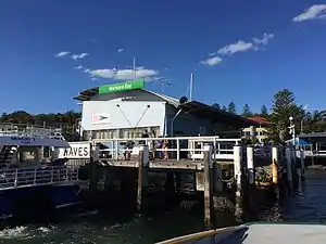
Watsons Bay ferry wharf
Watsons Bay ferry wharf is located on the southern side of Sydney Harbour serving the Sydney suburb of Watsons Bay.
Watsons Bay | |||||||||||
|---|---|---|---|---|---|---|---|---|---|---|---|
 Watsons Bay ferry wharf in April 2017 | |||||||||||
| Location | Military Road, Watsons Bay New South Wales Australia | ||||||||||
| Coordinates | 33°50′36″S 151°16′52″E | ||||||||||
| Owned by | Transport for NSW | ||||||||||
| Operated by | Transdev Sydney Ferries | ||||||||||
| Platforms | 1 wharf (2 berths) | ||||||||||
| Connections | |||||||||||
| Other information | |||||||||||
| Status | Unstaffed | ||||||||||
| Services | |||||||||||
| |||||||||||
Services
Watsons Bay wharf is served by Sydney Ferries Watsons Bay services operated by SuperCat class ferries.[1]
Watsons Bay wharf is also served by Captain Cook Cruises peak hour commuter services to Circular Quay.[2] At other times the Captain Cook Cruises Hop On/Hop Off Sydney Harbour ferry service operates via Watsons Bay wharf.[3]
My Fast Ferry operates Sydney Harbour tourist services via Watsons Bay.[4]
| Platform | Line | Stopping pattern | Notes |
| 1 | Services to Circular Quay | ||
|---|---|---|---|
| peak hour only[2] | |||
| Captain Cook Cruises Harbour Explorer |
| [3] | |
| My Fast Ferry Cruises |
| [4] |
Interchanges
State Transit operate three routes from the other side of Robertson Park:
- 324: to Circular Quay via Vaucluse[5]
- 325: to Circular Quay via Nielsen Park[6]
- 380: to Bondi Junction via Bondi Beach[7]
References
- "F9 Watsons Bay ferry timetable". Transport for NSW.
- "Watsons Bay Rocket timetable" (PDF). Captain Cook Cruises.
- "Harbour Explorer timetable" (PDF). Captain Cook Cruises. 15 December 2018.
- Watsons Bay Sightseeing Cruise My Fast Ferry
- "State Transit route 324". Transport for NSW.
- "State Transit route 325". Transport for NSW.
- "State Transit route 380". Transport for NSW.
External links
| Wikimedia Commons has media related to Watsons Bay ferry wharf, Sydney. |
- Watsons Bay Wharf at Transport for New South Wales (Archived 13 June 2019)
- Watsons Bay Local Area Map Transport for NSW
This article is issued from Wikipedia. The text is licensed under Creative Commons - Attribution - Sharealike. Additional terms may apply for the media files.