Volant, Pennsylvania
Volant is a borough in Lawrence County, Pennsylvania, United States. The population was 168 at the 2010 census.[4] It is surrounded by Old Order Amish farms of the New Wilmington settlement.
Volant, Pennsylvania | |
|---|---|
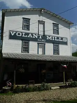
 Volant Mills | |
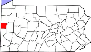
 Location in Lawrence County, Pennsylvania | |
 Volant Location in Pennsylvania  Volant Location in the United States | |
| Coordinates: 41°6′52″N 80°15′34″W | |
| Country | United States |
| State | Pennsylvania |
| County | Lawrence |
| Established | 1868 |
| Government | |
| • Mayor | Arnold Hodge |
| Area | |
| • Total | 0.12 sq mi (0.31 km2) |
| • Land | 0.11 sq mi (0.29 km2) |
| • Water | 0.01 sq mi (0.02 km2) |
| Elevation [2] (middle of borough) | 1,050 ft (320 m) |
| Highest elevation [2] (northwest end of borough) | 1,160 ft (350 m) |
| Lowest elevation | 1,000 ft (300 m) |
| Population (2010) | |
| • Total | 168 |
| • Estimate (2019)[3] | 151 |
| • Density | 1,348.21/sq mi (518.98/km2) |
| Time zone | UTC-4 (EST) |
| • Summer (DST) | UTC-5 (EDT) |
| Area code(s) | 724 |
History
The land on which the borough of Volant currently sits on was bought from the Native Americans in 1784. The first gristmill was built on Neshannock Creek in 1806, upstream from the current site. It was abandoned after a few years, and a new mill was built in 1812 at its current location.
In 1847 an Amish settlement was established between New Wilmington and Volant.[5] In 1868, J.P. Locke purchased the mill and 100 acres (0.40 km2) of land and began laying out a settlement of 30 lots, which he called Lockeville. With the help of the railroad, his attempts to create a settlement were successful. Lockeville began to grow and prosper, and in June 1893 the settlement changed its name to Volant and was incorporated as a self-governing unit.
The first store was built in 1877 by John and William Graham. By the turn of the 20th century the village was a bustling commercial community. Thanks to the New Castle-Franklin railroad Volant became a popular shopping district. The mill remained the nucleus of the town. Because of Volant's rural location there was a livery stable, two harness shops, a blacksmith and a veterinarian, as well as some shops. In addition, there was a college which attracted students from the surrounding communities. As the town progressed toward establishing larger business ventures, a stone quarry was begun around 1900, as well as a lumber mill and brick company. The growing need for petroleum spurred an oil boom north of Volant. The drilling continued until the beginning of World War I.
With the Great Depression came a gradual decline of the economy. As the economy worsened the business district diminished to almost nothing. The mill, which was primarily responsible for Volant's success, closed its doors in the early 1960s, and the trains stopped running through Volant in 1975. Volant soon became forgotten and returned to its rural roots.
In 1984, a renaissance began with the old mill as its centerpiece. Opening its doors for the first time in over 20 years as a country gift and antique store, it paved the way for a business revival that still continues. Encouraged by its success, other shops were opened on Main Street. After several years of rapid growth, there are now over 50 shops and restaurants, turning Volant from a sleepy little village into one of western Pennsylvania's most popular tourist attractions.[6]
Geography
Volant is located at 41°6′52″N 80°15′34″W (41.114489, -80.259463).[7]
According to the United States Census Bureau, the borough has a total area of 0.1 square miles (0.26 km2), all of it land.
Volant is a unique village of quaint shops and restaurants located on Pennsylvania Route 208 only 10 minutes from I-79 and I-80. It has an old-fashioned main street nestled in the rolling hills of scenic western Pennsylvania Amish country.
Surrounding neighborhoods
Volant has two borders, including Wilmington Township the north, south and west, and Washington Township to the east, northeast and southeast.
Demographics
| Historical population | |||
|---|---|---|---|
| Census | Pop. | %± | |
| 1900 | 120 | — | |
| 1910 | 185 | 54.2% | |
| 1920 | 211 | 14.1% | |
| 1930 | 186 | −11.8% | |
| 1940 | 237 | 27.4% | |
| 1950 | 229 | −3.4% | |
| 1960 | 213 | −7.0% | |
| 1970 | 226 | 6.1% | |
| 1980 | 203 | −10.2% | |
| 1990 | 152 | −25.1% | |
| 2000 | 113 | −25.7% | |
| 2010 | 168 | 48.7% | |
| 2019 (est.) | 151 | [3] | −10.1% |
| Sources:[8][9][10] | |||
As of the census[9] of 2000, there were 113 people, 55 households, and 37 families residing in the borough. The population density was 991.3 people per square mile (396.6/km²). There were 64 housing units at an average density of 561.5 per square mile (224.6/km²). The racial makeup of the borough was 100.00% White.
There were 55 households, out of which 20.0% had children under the age of 18 living with them, 49.1% were married couples living together, 10.9% had a female householder with no husband present, and 32.7% were non-families. 29.1% of all households were made up of individuals, and 12.7% had someone living alone who was 65 years of age or older. The average household size was 2.05 and the average family size was 2.49.
In the borough the population was spread out, with 15.9% under the age of 18, 8.0% from 18 to 24, 23.9% from 25 to 44, 30.1% from 45 to 64, and 22.1% who were 65 years of age or older. The median age was 46 years. For every 100 females there were 88.3 males. For every 100 females age 18 and over, there were 75.9 males.
The median income for a household in the borough was $30,625, and the median income for a family was $37,917. Males had a median income of $38,750 versus $25,417 for females. The per capita income for the borough was $17,642. There were 6.1% of families and 7.9% of the population living below the poverty line, including 12.5% of those under 18 and 7.1% of those over 64.
Volant is sourrounded by farms of the New Wilmington Amish settlement which had 19 congregation i.e. about 2,500 people in 2013.[5]
References
| Wikimedia Commons has media related to Volant, Pennsylvania. |
- "2019 U.S. Gazetteer Files". United States Census Bureau. Retrieved July 28, 2020.
- "Volant Topo Map, Lawrence County PA (New Castle North Area)". TopoZone. Locality, LLC. Retrieved 5 September 2019.
- "Population and Housing Unit Estimates". United States Census Bureau. May 24, 2020. Retrieved May 27, 2020.
- "Profile of General Population and Housing Characteristics: 2010 Demographic Profile Data (DP-1): Volant borough, Pennsylvania". United States Census Bureau. Retrieved March 27, 2012.
- Donnermeyer, Joe; Luthy, David (2019-10-21). "Amish Settlements across America: 2013". Journal of Amish and Plain Anabaptist Studies. 1 (2): 107–129. ISSN 2471-6383.
- "Volant History". Volant Village Shops. Retrieved 15 June 2018.
- "US Gazetteer files: 2010, 2000, and 1990". United States Census Bureau. 2011-02-12. Retrieved 2011-04-23.
- "Census of Population and Housing". U.S. Census Bureau. Retrieved 11 December 2013.
- "U.S. Census website". United States Census Bureau. Retrieved 2008-01-31.
- "Incorporated Places and Minor Civil Divisions Datasets: Subcounty Resident Population Estimates: April 1, 2010 to July 1, 2012". Population Estimates. U.S. Census Bureau. Archived from the original on 11 June 2013. Retrieved 11 December 2013.

