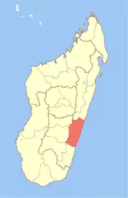
Vatovavy-Fitovinany
Vatovavy-Fitovinany is a region located in southeast Madagascar. Its capital is Manakara. It is inhabited by the Antemoro people.
Vatovavy-Fitovinany | |
|---|---|
Region | |
 Location in Madagascar | |
| Country | |
| Capital | Manakara |
| Area | |
| • Total | 19,605 km2 (7,570 sq mi) |
| Population (2018)[2] | |
| • Total | 1,435,882 |
| • Density | 73/km2 (190/sq mi) |
| Time zone | UTC3 (EAT) |
| HDI (2018) | 0.473[3] low · 14th of 22 |
The region extends along the southern part of the east coast of Madagascar. It is bordered by Atsinanana (North), Amoron'i Mania and Haute Matsiatra (West) and Atsimo-Atsinanana (South).
Administrative divisions
Vatovavy-Fitovinany region is divided into six districts, which are sub-divided into 122 communes.
Transportation mean
- Train (from Fianarantsoa)
- Car Taxi-Brousse
- Plane
- Manakara port is only used for product shipment and transit (Lychee, coffee, ...)
Protected areas
- Part of Fandriana-Vondrozo Corridor
- Part of Marolambo National Park
- Part of Ranomafana National Park
References
- Ralison, Eliane; Goossens, Frans. "Madagascar: Profil des marchés pour les évaluations d'urgence de la sécurité alimentaire" (PDF) (in French). Programme Alimentaire Mondial, Service de l’Evaluation des besoins d’urgence (ODAN). Retrieved 2008-03-01.
- "Troisieme Recensement General de la Population et de L'Habitation (RGPH-3) Resultats Provisoires" (PDF). Institut National de la Statistique Madagascar. Retrieved May 23, 2020.
- "Sub-national HDI - Area Database - Global Data Lab". hdi.globaldatalab.org. Retrieved 2018-09-13.
This article is issued from Wikipedia. The text is licensed under Creative Commons - Attribution - Sharealike. Additional terms may apply for the media files.