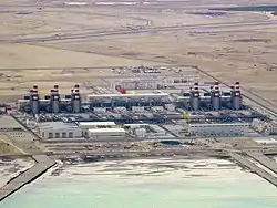
Umm Al Houl
Umm Al Houl (Arabic: ام الحول, romanized: Umm al Ḩūl) is an industrial district in Qatar located in the municipality of Al Wakrah.[3][4] To the north of Umm Al Houl is the city of Al Wakrah while Mesaieed is to the south.[4]
Umm Al Houl
ام الحول | |
|---|---|
District | |
 Umm Al Houl IWPP | |
 Umm Al Houl Location in Qatar | |
| Coordinates: 25°04′54″N 51°36′51″E[1] | |
| Country | |
| Municipality | Al Wakrah |
| Area | |
| • Total | 13 sq mi (34 km2) |
The government has designated the district as a free economic zone starting in early 2019.[2] Qatar's largest seaport, Hamad Port, is located here.[5]
Etymology
The first constituent, 'umm', is the Arabic word for mother and is a common prefix used to denote geographical features. 'Houl' is an Arabic term reserved for a type of snare. Historically, birds of considerable size were commonly caught here using traps, lending the area its name.[4]
Geography
Strategically located to the immediate north of the Mesaieed Industrial Area and approximately 20 kilometres (12 mi) south of Hamad International Airport, the area was chosen as a maritime hub for its suitable geography and close distance to Qatar's industrial and economic centers.[2]
History
In 1895 the Sheikh of Abu Dhabi attempted to claim it as his western frontier but his claim was rejected by his superiors in the British government.[6]
J.G. Lorimer's Gazetteer of the Persian Gulf gives an account of Umm Al Houl in 1908, referring to it as "Dohat [bay] Umm al-Hūl" and giving its location as 5 miles south of Al Wakrah. He goes on to state:
There was formerly a small settlement of the Sudan [Suwaidi] tribe here, but it has been abandoned in consequence of the badness of the water supply. Remains are visible of a village and fort.[7]
Umm Al Houl Power Plant
After being launched in 2015, the Umm Al Houl Power Plant was commissioned in March 2018. The plant has the capacity to desalinate 136.5 million gallons of water daily, meeting approximately 40% of Qatar's requirement, as well as a generation capacity of 2,520 MW.[8]
Transport
Currently, the elevated Umm Al Houl Metro Station is under construction, having been launched during Phase 2A. Once completed, it will be part of Doha Metro's Red Line South.[9]
Gallery
 Umm Al Houl depicted as Amulhool in an 1829 map.
References
- "Umm al Ḩūl: Qatar". geographic.org. Retrieved 14 January 2019.
- "Um Al Houl". Manateq. Retrieved 14 January 2019.
- "Qatar Development Atlas - Part 1" (PDF). Ministry of Development Planning and Statistics. 2010. p. 10. Retrieved 14 January 2019.
- "District map". The Centre for Geographic Information Systems of Qatar. Retrieved 14 January 2019.
- Kim Kemp (2 March 2015). "Hamad Port will become fully operational in 2016". Construction Week Online. Retrieved 14 January 2019.
- "'Gazetteer of the Persian Gulf. Vol. II. Geographical and Statistical. J G Lorimer. 1908' [405] (448/2084)". Qatar Digital Library. Retrieved 14 January 2019.
- "'Gazetteer of the Persian Gulf. Vol. II. Geographical and Statistical. J G Lorimer. 1908' [1508] (1623/2084)". Qatar Digital Library. Retrieved 19 January 2019.
- "Umm Al Houl Power Plant: Water & Energy Security in Qatar". Qatar-America Institute. Retrieved 2 August 2019.
- "QAR Metro". arcgis.com. Retrieved 17 March 2019.