Subdivisions of the canton of Bern
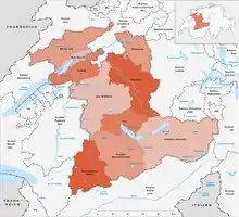
On 1 January 2010, the 26 districts (German: Amtsbezirke, French: districts) were combined into 10 new precincts (German: Verwaltungskreise, French: arrondissement administratif):[1]
They are grouped into five regions (German: Verwaltungsregionen).
The existence of the 26 districts remains through the laws and Constitution of the Canton of Berne (Art.3 al.2 Cst) and coexists with the new 10 precincts (German: Verwaltungskreise, French: arrondissement administratif).
As of 2007 there were 391 municipalities of the canton of Bern.
Precincts 2010

| New district (Verwaltungskreis) | Capital | Region | Former district(s) (Amtsbezirk) |
|---|---|---|---|
| Bern-Mittelland | Ostermundigen | Bern-Mittelland | Bern, Fraubrunnen, Konolfingen, Laupen, Schwarzenburg and Seftigen |
| Biel/Bienne | Biel/Bienne | Seeland | Biel and about half of Nidau |
| Emmental | Langnau im Emmental | Emmental-Oberaargau | Burgdorf, Signau and Trachselwald |
| Frutigen-Niedersimmental | Frutigen | Bernese Oberland | Frutigen and Niedersimmental |
| Interlaken-Oberhasli | Interlaken | Bernese Oberland | Interlaken and Oberhasli |
| Jura bernois | Courtelary | Jura Bernois Region | Courtelary, Moutier and La Neuveville |
| Oberaargau | Wangen an der Aare | Emmental-Oberaargau | Aarwangen and Wangen |
| Obersimmental-Saanen | Saanen | Bernese Oberland | Obersimmental and Saanen |
| Seeland | Aarberg | Seeland | Aarberg, Büren, Erlach and about half of Nidau |
| Thun | Thun | Bernese Oberland | Thun |
Districts

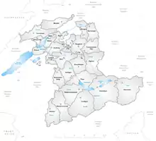
The canton of Bern is also subdivided into 26 districts (German: Amtsbezirke; French: districts), which have no more administrative or political significance since the introduction of the new larger administrative subdivisions listed above.
The districts are:
- Aarberg with capital Aarberg
- Aarwangen with capital Aarwangen
- Bern with capital Bern
- Biel with capital Biel
- Büren with capital Büren an der Aare
- Burgdorf with capital Burgdorf
- Courtelary with capital Courtelary
- Erlach with capital Erlach
- Fraubrunnen with capital Fraubrunnen
- Frutigen with capital Frutigen
- Interlaken with capital Interlaken
- Konolfingen with capital Konolfingen
- Laupen with capital Laupen
- Moutier with capital Moutier
- La Neuveville with capital La Neuveville
- Nidau with capital Nidau
- Niedersimmental with capital Wimmis
- Oberhasli with capital Meiringen
- Obersimmental with capital Blankenburg
- Saanen with capital Saanen
- Schwarzenburg with capital Schwarzenburg
- Seftigen with capital Belp
- Signau with capital Langnau im Emmental
- Thun with capital Thun
- Trachselwald with capital Trachselwald
- Wangen with capital Wangen an der Aare
Maps 1978 - 2010
 Amtsbezirke until 31 December 1978
 Amtsbezirke until 31 December 1993
 Amtsbezirke until 31 December 2009
Notes and references
- Amtliches Gemeindeverzeichnis der Schweiz, Mutationsmeldungen 2009 / Répertoire officiel des communes de Suisse, Mutations 2009 / Elenco ufficiale dei Comuni della Svizzera, Mutazione 2009 (PDF) (Report). Federal Statistical Office. 2009. nden. Archived from the original (PDF) on 18 November 2010. Retrieved 6 March 2010.