State Highway 77 (New Zealand)
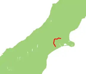
State Highway 77 is a state highway in New Zealand going through the inland parts of Central and Mid Canterbury between the towns of Ashburton and Darfield via the Rakaia Gorge. It is wholly single carriageway with two one-lane bridges at the Rakaia and Selwyn Rivers. One set of traffic lights is found in Ashburton marking the southern terminus of the highway.
| ||||
|---|---|---|---|---|
 | ||||
| Route information | ||||
| Maintained by NZ Transport Agency | ||||
| Length | 93.9 km (58.3 mi) | |||
| Tourist routes | Inland Scenic Route between Homebush and Mount Hutt | |||
| Major junctions | ||||
| Northwest end | ||||
| Southeast end | ||||
| Location | ||||
| Primary destinations | Coalgate, Glentunnel, Rakaia Gorge, Methven | |||
| Highway system | ||||
| ||||
About 43 km of the highway lie on the Inland Scenic Route (formerly State Highway 72).
Route


The highway begins as Bangor Road just west of Darfield town centre, and proceeds in a westerly directions towards the mountains through flat pastoral farmland. Just before reaching the foothills, the road intersects with the Inland Scenic Route (Deans Road) coming from Waddington and begins its concurrency at Homebush. After a name change to Homebush Road, the road skirts to the north of Coalgate and then to the south of Glentunnel before veering left and narrowing to one lane to cross the Selwyn River.
Now known as Wairiri Road, the road widens back to two lanes and passes through undulating to hilly farmland. At Glenroy the road changes name to Windwhistle Road and climbs towards the settlement of Windwhistle.
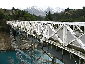
Beyond Windwhistle, the name changes to Rakaia Gorge Road and begins a spectacular descent into the Rakaia Gorge. For most of its length the Rakaia River runs on shingle river beds as a braided river but here the river is mostly a single channel. The river here has carved out the surrounding land to form two level terraces. The road passes over both these terraces before narrowing to one lane again to cross the river.
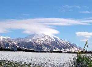
After widening again, the road changes name to Arundel Rakaia Gorge Road and rises towards the plains again. The road emerges onto the plains but passes right underneath the towering Mount Hutt. The road is frequently covered by snow and ices over in sheltered areas during the calmer periods of the winter months in higher parts of the road.
The road turns left onto Waimarama Road 10 km north of Alford Forest and proceeds through arable farmland, changes name again to Mount Hutt Station Road and arrives in Methven, where it changes name again to Main Street.
After Methven, the road changes name to Methven Highway and proceeds in a south to southeasterly direction through more pastoral farmland. Before Ashburton, the road hugs the Ashburton River, the name of the road changes to Alford Forest Road for about 2 km, then to River Terrace for 600 m and lastly to Moore Street for the last 300 m of the route before terminating at SH 1 in the town centre.[1]
Route changes
When SH 72 had its state highway status revoked, SH 77 was extended to cover the section between (its former terminus) Mount Hutt and Waddington. In 1997, SH 77 was diverted at the intersection of Homebush Road, along Bangor Road, to terminate with SH 73 at Darfield.[2]
Major intersections
| Territorial authority | Location | km | jct | Destinations | Notes |
|---|---|---|---|---|---|
| Ashburton District | Ashburton Central | 0.0 | (Moore Street) – Town Centre | SH 77 begins | |
| 6.0 | (Ashburton Staveley Road) – Mount Somers, Alford Forest, Staveley | ||||
| 22.3 | (Thompsons Track) – Mount Somers, Mayfield, Rakaia, Christchurch ( | ||||
| Methven | 33.9 | (Forest Drive) – Mount Somers, Geraldine (Methven Chertsey Road) – Lauriston | |||
| 36.6 | (Mount Hutt Station Road) – Rakaia Gorge (alternative route) | ||||
| 43.6 | (McLennans Bush Road) – Mount Hutt Ski Area | SH 77/Inland Scenic Route (Regional Route 72) concurrency begins | |||
| Mount Hutt | 49.0 | (Mount Hutt Station Road) – Methven (alternative route) | |||
| Rakaia Gorge | 53.0 | Rakaia River Bridge #1 | |||
| Selwyn District | |||||
| Windwhistle | 59.4 | (Coleridge Road) – Lake Coleridge (Leaches Road) – Hororata | |||
| 70.0 | (Downs Road) – Hororata | ||||
| Glentunnel | 79.0 | Selwyn River Bridge | |||
| 79.2 | (Whitecliffs Road) – Whitecliffs | ||||
| Coalgate | 82.8 | (Malvern Hills Road) (Bridge Street) – Coalgate, Hororata | |||
| 86.0 | SH 77/Inland Scenic Route (Regional Route 72) concurrency ends | ||||
| Darfield | 94.0 | SH 77 ends |
See also
References
- State Highway 77 on Google Maps
- "Revoking Sections of State Highways Declaring New Sections of State Highway". New Zealand Gazette. 26 June 1997. Retrieved 5 July 2016.
