Sonpur community development block
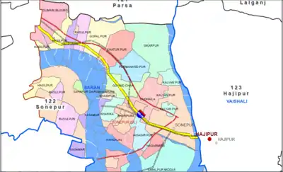
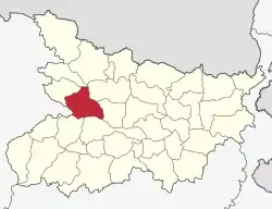
Sonpur Community development block (C.D.Block; Hindi: सोनपुर सामुदायिक विकास प्रखंड) is a rural area earmarked for administration and development in Saran district.[3] The area is administered by a Block Development Officer. It is the second largest Block of Saran district in terms of population. A community development block covers several gram panchayats, Panchayat Samiti (Block), Primary Agricultural Co-operative societies (PACS) and other local administrative unit at the village level. It is represented by Sonpur Vidhan Sabha constituency in Bihar Legislative Assembly [4] and Saran Lok Sabha constituency in Indian parliament. Currently, C.D.Blocks are administrative units of 3rd level in Bihar state of India (equal to Tehsil in other states). Sonpur nagar panchayat was established in 2002.[5] The civic body election in Sonpur nagar panchayat was held in May 2017.[6] The term of office-bearers is for 5 years.
Sonpur
सोनपुर सामुदायिक विकास प्रखंड | |
|---|---|
Community Development Block | |
 Sonpur Location in Bihar, India | |
| Coordinates: 25.73°N 85.18°E | |
| Country | |
| State | Bihar |
| District | Saran |
| Government | |
| • Type | Community development block |
| Area | |
| • Total | 159.65 km2 (61.64 sq mi) |
| Elevation | 43 m (141 ft) |
| Population (2011) | |
| • Total | 232,340[1][2] |
| • Density | 1,455/km2 (3,770/sq mi) |
| Languages | |
| • Official | Bhojpuri, Hindi |
| Time zone | UTC+5:30 (IST) |
| ISO 3166 code | IN-BR |
| Lok Sabha constituency | Saran |
| Vidhan Sabha constituency | Sonpur (Vidhan Sabha constituency) |
| Website | Sonpur Block, Saran Website, under Integrated Block Information system |
The real estate land prices soared in Sonepur after the start of construction of Digha–Sonpur rail–cum–road bridge in 2002.[7] Real estate companies like RAV solutions pvt. ltd, tcw realty pvt ltd, Phenomenal Projects are acquiring large chunk of land and selling it by dividing those into small plots.[8][9][10] Sonpur Block(प्रखण्ड) has 98 villages.[11] Sonpur Sub-division(अनुमंडल) consists of Sonepur, Parsa, Garkha, Dighwara, Dariapur blocks.[12] Sonpur Block has 23 Village Panchayats and 73 villages.[13]
Demographics
Sonpur Block of Saran district has population of 232,340(2011 census). 14% people lives in Urban areas while 86% lives in the Rural areas. Currently there are 20 community development blocks in the district. As of Ministry of Drinking Water and Sanitation 2009 report and 2011 Census, these were the findings.[14]
| Block Name | SC | ST | General and OBC | Total |
|---|---|---|---|---|
| Sonpur | 22400 | 79 | 209861 | 232340 |

Gram Panchayats
Sonpur block has 1 Nagar Panchayat and 23 Gram Panchayats.[15] Number of villages is 116.[16] They are:[17]
- Dumri Bujurg
- Hasilpur
- Nayagaon
- Rasulpur
- Gopalpur
- Chaturpur
- Parmanandpur
- Govindchak
- Saidpur
- Kasmar
- Kharika
- Gangajal
- Bharpura
- Shahpur Diyara
- Jahangirpur
- Dudhaila
- Shikarpur village, Saran district
- Kalyanpur village, Saran district
- Najarmira
- Sabalpur Uttari
- Sabalpur Pashchimi
- Sabalpur Madhyavarti
- Sabalpur Purvi
References
- "Page 34 and Page 312 - 159.65 sq. km = 15,965 hectares http://www.censusindia.gov.in/2011census/dchb/1017_PART_B_DCHB_SARAN.pdf" (PDF). External link in
|title=(help) - "INDIA: Bihar, Cities, Towns and Outgrowth Wards". citypopulation.de. Retrieved 21 February 2014.
- "Sonepur Block map" (PDF).
- Blocks in Parsa Vidhan sabha, Bihar Legislative assembly
- "वर्ष 2002 में गठित सोनपुर नगर पंचायत 16 वर्षों के इतिहास में ऐसा कभी नहीं हुआ जो अब हो रहा है।".
- "More women than men in Saran poll fray".
- "Realty to broaden horizon".
- "यहां मिलेगा 15 लाख रुपए में फ्लैट, गंगा किनारे लग्जुरियस लाइफ जीने का मौका".
- "पटना से सटे सोनपुर बना रियल एस्टेट का बड़ा बाजार सस्ती प्रॉपर्टी खरीदने का मौका".
- "TCW Reality" (PDF).
- http://www.census2011.co.in/data/subdistrict/1267-sonepur-saran-bihar.html
- "सोनपुर अनुमंडल".
- "Villages & Towns in Sonpur Block of Saran, Bihar".
- ministry of drinking water and sanitation 2009 - Dariyapur block population
- "Blocks and Panchayats in Bihar".
- http://eblocks.bih.nic.in/BlockProfile.aspx?DistCode=219&BLKCode=1267
- http://www.jagran.com/bihar/vaishali-panchayat-representatives-took-the-oath-of-office-14212124.html
