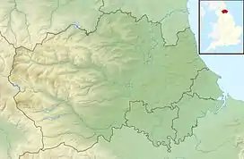
Slit Woods
Slit Woods is a Site of Special Scientific Interest in the Wear Valley district of County Durham, England. It occupies the valley of Middlehope Burn, a tributary of the River Wear, which it joins at Westgate, just south of the site.
| Slit Woods | |
|---|---|
 Location of Slit Woods SSSI, Co Durham | |
| Location | Wear Valley, North East, England |
| Coordinates | 54°44′47″N 2°8′48″W |
| Area | 14.1 ha (35 acres) |
| Established | 1976 |
| Governing body | Natural England |
| Website | Map of site |
The site has a variety of habitats, including woodland, calcareous grassland, fen, and revegetated mine workings.
The woodland is characterised by ash, Fraxinus excelsior, and wych elm, Ulmus glabra, over an understorey of hazel, Corylus avellana. The ground cover includes great bell-flower, Campanula latifolia, globeflower, Trollius europaeus, wood cranesbill, Geranium sylvaticum, and marsh hawk's-beard, Crepis paludosa.
The site takes in the disused workings of two former lead mines, Slit Mine and Middlehope Mine. The waste from these mines supports open grassland within which the metallophyte spring sandwort, Minuartia verna, has established itself.[1]
References
- "Slit Woods" (PDF). English Nature. 1987. Retrieved 1 August 2010.