Sissa River
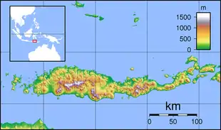
Sissa River (Aesesa River) is a river of Flores, East Nusa Tenggara, Indonesia.[1][2] The 87-km river flows from southwest to northeast direction, with the upstream at Mount Inielika north of Bajawa, Ngada Regency and discharge into Flores Sea near Mbay, Nagekeo Regency.
| Sissa River Ai Sissa, Ai Sisa, Waesesa, Wae Woki River | |
|---|---|
 Location of the river  Sissa River (Lesser Sunda Islands)  Sissa River (Indonesia) | |
| Native name | Aesesa |
| Location | |
| Country | Indonesia |
| State | East Nusa Tenggara |
| Physical characteristics | |
| Source | Inielika |
| • location | Flores |
| • elevation | 1,400 m (4,600 ft) |
| Mouth | Flores Sea |
• coordinates | 8°29′S 121°18′E |
| Length | 87 km (54 mi) |
| Basin size | 1,230 km2 (470 sq mi) |
| Discharge | |
| • average | 7.5 m3/s (260 cu ft/s) |
Hydrology
The watershed (Indonesian: Daerah Aliran Sungai/DAS) Aesesa has an area of 1,230 km2 with round form, comprising two regencies: Ngada Regency and Nagekeo Regency. The upstream at Ngada Regency near Bajawa is called "Wae Woki river". The major tributaries are:
- Ae Mau river
- Lowo Ulu river
- Lowo Langge river
- Lowo Lele river
- Lowo Me Bhada river
- Wae Bia river
- Wae Bhara river
Aesesa river has a length of 87 km[3] with an average discharge of around 7.5 m3/second[4]
Uses
The inhabitants along the Aesesa River use the water for agriculture, with the help of "Sutami Dam" at Nggolo Mbay, District of Aesesa, Nagekeo Regency which distributes the water to farmlands around 6,452 hectare in Nagekeo Regency at an average discharge of 14.69 m3/second.[5] At the upstream, there is several waterfalls, like "Ogi waterfall" and "Soso waterfall". Ogi waterfall has a height of more than 30-meter and is utilized as a major tourist attraction of Bajawa.[6]
Geography
| Aesesa | ||||||||||||||||||||||||||||||||||||||||||||||||||||||||||||
|---|---|---|---|---|---|---|---|---|---|---|---|---|---|---|---|---|---|---|---|---|---|---|---|---|---|---|---|---|---|---|---|---|---|---|---|---|---|---|---|---|---|---|---|---|---|---|---|---|---|---|---|---|---|---|---|---|---|---|---|---|
| Climate chart (explanation) | ||||||||||||||||||||||||||||||||||||||||||||||||||||||||||||
| ||||||||||||||||||||||||||||||||||||||||||||||||||||||||||||
| ||||||||||||||||||||||||||||||||||||||||||||||||||||||||||||
The river flows in the middle to the north of Flores with predominantly tropical savanna climate (designated as Aw in the Köppen-Geiger climate classification).[8] The annual average temperature in the area is 26 °C. The warmest month is November, when the average temperature is around 30 °C, and the coldest is February, at 23 °C.[7] The average annual rainfall is 1686 mm. The wettest month is January, with an average of 302 mm rainfall, and the driest is September, with 8 mm rainfall.[9]
References
- Rand McNally, The New International Atlas, 1993.
- Ai Sissa at Geonames.org (cc-by); Last updated 17 January 2012; Database dump downloaded 27 November 2015
- Rough measurement of major river length DAS Waesesa and Sub-DAS Wae Woki.
- (in Indonesian)Tingkat Kerentanan SDA DAS Easesa
- Potensi Pengembangan Daerah Irigasi Mbay
- Air Terjun Ogi Bejawa
- "NASA Earth Observations Data Set Index". NASA. 30 January 2016.
- Peel, M C; Finlayson, B L; McMahon, T A (2007). "Updated world map of the Köppen-Geiger climate classification". Hydrology and Earth System Sciences. 11 (5): 1633–1644. doi:10.5194/hess-11-1633-2007.
- "NASA Earth Observations: Rainfall (1 month – TRMM)". NASA/Tropical Rainfall Monitoring Mission. 30 January 2016.