Shawlands
Shawlands (Scottish Gaelic: Fearann na Doire)[3] is an area of Glasgow, Scotland, located around 2 miles (3 kilometres) south of the River Clyde. The area has an approximate population of 7000, with over 82% dwelling in flats, 74% owner occupied and 79% living alone or with one other person.[4]
Shawlands
| |
|---|---|
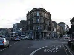
 Shawlands Cross, Glasgow (2005) | |
| Area | 0.52 km2 (0.20 sq mi) [1] |
| Population | 7,015 (2015)[2] |
| • Density | 13,490/km2 (34,900/sq mi) |
| Council area | |
| Country | Scotland |
| Sovereign state | United Kingdom |
| Post town | GLASGOW |
| Postcode district | G41 3 |
| Dialling code | 0141 |
| Police | Scotland |
| Fire | Scottish |
| Ambulance | Scottish |
| UK Parliament | |
Neighbouring districts include the areas of Auldhouse, Crossmyloof, Strathbungo, Langside, Newlands, and Pollokshaws,[5] with Shawlands itself overlapping two Council wards (Pollokshields and Langside) and two Scottish Parliament constituencies (Glasgow Cathcart and Glasgow Southside). The area consists mainly of tenement flats but also includes two-storey terraced cottages and a small number of detached and semi-detached houses.[4] Tenements remain the most common form of dwelling in the city today.
Cultural amenities
Within walking distance of Shawlands is Queens Park, acquired in 1857 and designed by the world-renowned Sir Joseph Paxton, also responsible for noted public parks in London, Liverpool, Birkenhead and the grounds of the Spa Buildings at Scarborough. The park was dedicated to the memory of Mary, Queen of Scots and not Queen Victoria, a common misconception given the proximity to Victoria Road. The park is steeped in history and was the site of the 16th century Battle of Langside.[4] The park also has allotments, a botanical glass house, public tennis courts, a public golf course, children's play areas, a boating pond and views of Glasgow. The refurbished amphitheatre holds open-air performances of Shakespeare and children's plays during summer. The park holds the annual Southside Festival,[6] and the Wee Chill Music Festival.
Education
Shawlands Primary School has an approximate capacity of over 600 pupils and is part of the 'Shawlands New Learning Community' (which also includes Annette St Primary, Battlefield Primary, Blackfriars Primary, Cuthbertson Primary and Langside Primary) feeding to the non denominational secondary school in the area, Shawlands Academy, which has an approximate capacity of over 1,200 pupils. The school has just undergone an extensive renovation which has seen it transformed into Glasgow’s specialist languages centre; the Glasgow International School, the first of its kind in Scotland, also houses the bilingual Support Unit.[4] It is estimated that over 50 languages are currently spoken by the school's pupils, representing the diverse multicultural pupil population.
Also in Shawlands is St. Conval's Primary, a Roman Catholic School situated on Shawhill Road; St. Conval's is part of the Learning Community for Holyrood R.C. Secondary School situated in the Crosshill area.
Religion
Religious establishments within the district include: Shawlands Kirk, Saint Helen's, Destiny Church and Re:Hope Southside.
Sport
Fitness First, located on Kilmarnock Road, provides gym and aerobic exercise classes. The area is also home to Shawlands bowling club and Pro Judo, the largest judo club in the West of Scotland. Hampden Park, Scotland's national stadium and home of Queens Park Football Club is located less than 2 mi (3 km) from Shawlands Cross. Also just South of Shawlands is Newlandsfield Park home of Pollok FC.
Transport
Road
Shawlands has close links to the M77 and M8 motorways (accessing at Dumbreck Road). Shawlands has two main roads which converge at Shawlands Cross: Kilmarnock Road and Pollokshaws Road.[7][8] At the cross, the designation of the A77 road changes to Kilmarnock Road running south, with Pollokshaws Road continuing south-west as a more minor route.
Bus services (the majority operated by First Glasgow) in the area are frequent, running from Glasgow city centre 24 hours a day.
Rail
The area is within walking distance of Crossmyloof Railway Station, Shawlands Railway Station and Pollokshaws East Railway Station. All stations have direct links to the city centre, terminating at Glasgow Central Station. Journey times to the city centre are under 10 minutes and services are provided by Scotrail.
Air
Shawlands is located 8.8 mi (14.2 km) from Glasgow Airport and about 24 mi (39 km) from Glasgow Prestwick Airport.
References
- "statistics.gov.scot : Land Area (based on 2011 Data Zones)". statistics.gov.scot.
- "statistics.gov.scot : Population Estimates (Current Geographic Boundaries)". statistics.gov.scot.
- "Ainmean-Àite na h-Alba (AÀA) – Gaelic Place-names of Scotland". Gaelicplacenames.org. Retrieved 3 June 2018.
- Glasgow Young Scot, 20 Trongate (17 November 2015). Glasgow.gov.uk https://www.glasgow.gov.uk/index.aspx?articleid=17877. Retrieved 3 June 2018. Missing or empty
|title=(help) - Auldhouse and Shawlands (West of Scotland Archaeology Service,1950), The Glasgow Story
- "Archived copy". Archived from the original on 14 September 2010. Retrieved 25 September 2010.CS1 maint: archived copy as title (link)
- Glasgow’s Crosses, Glasgow History, 28 May 2016
- Shawlands Cross (Mitchell Library, Glasgow Collection, Postcards Collection), The Glasgow Story